3248
Proceedings of the 18
th
International Conference on Soil Mechanics and Geotechnical Engineering, Paris 2013
presented from Hungary, Italy, Poland and Slovakia do,
however, not take climate change into consideration.
The literature survey revealed that a large range of
conference papers can be of interest when working with soil
movements for example [3] describes the EU project
Response
:
“Applied earth science mapping for evaluation of climate
change impacts on coastal hazards and risk across the EU”. The
methodology employs commonly available digital data sets in
GIS to assess regional-scale levels of coastal risk through
production of series of maps. The outputs of the methodology
comprise factual data maps and thematic maps and non-
technical summary maps as planning guidance.
An on-going EU project is the KULTU-Risk project [4]. It
will focus on water-related hazards. In particular, a variety of
case studies characterised by diverse socio-economic contexts,
different types of water-related hazards (floods, debris flows
and landslides, storm surges) and space-time scales will be
utilised [4].
In the UK there is a Climate Impact Programme (UKCIP)
that contains a range of tools, methods and guidance which can
be used for climate adaptation. The programme demonstrates
how and where they fit into a risk-based planning process.
There is also a National Appraisal of Assets and Risk from
Flooding and Coastal Erosion, with adaption options on [5].
In France Baills et al. [6] have developed a method for
integrating climate change scenarios into slope stability
mapping. The climate factor treated as a variable in the stability
calculation is the ground water level. Ground water levels are
calculated from a conceptual hydrological model driven by
rainfall data, and are described as filling ratio of the maximum
ground water level [2].
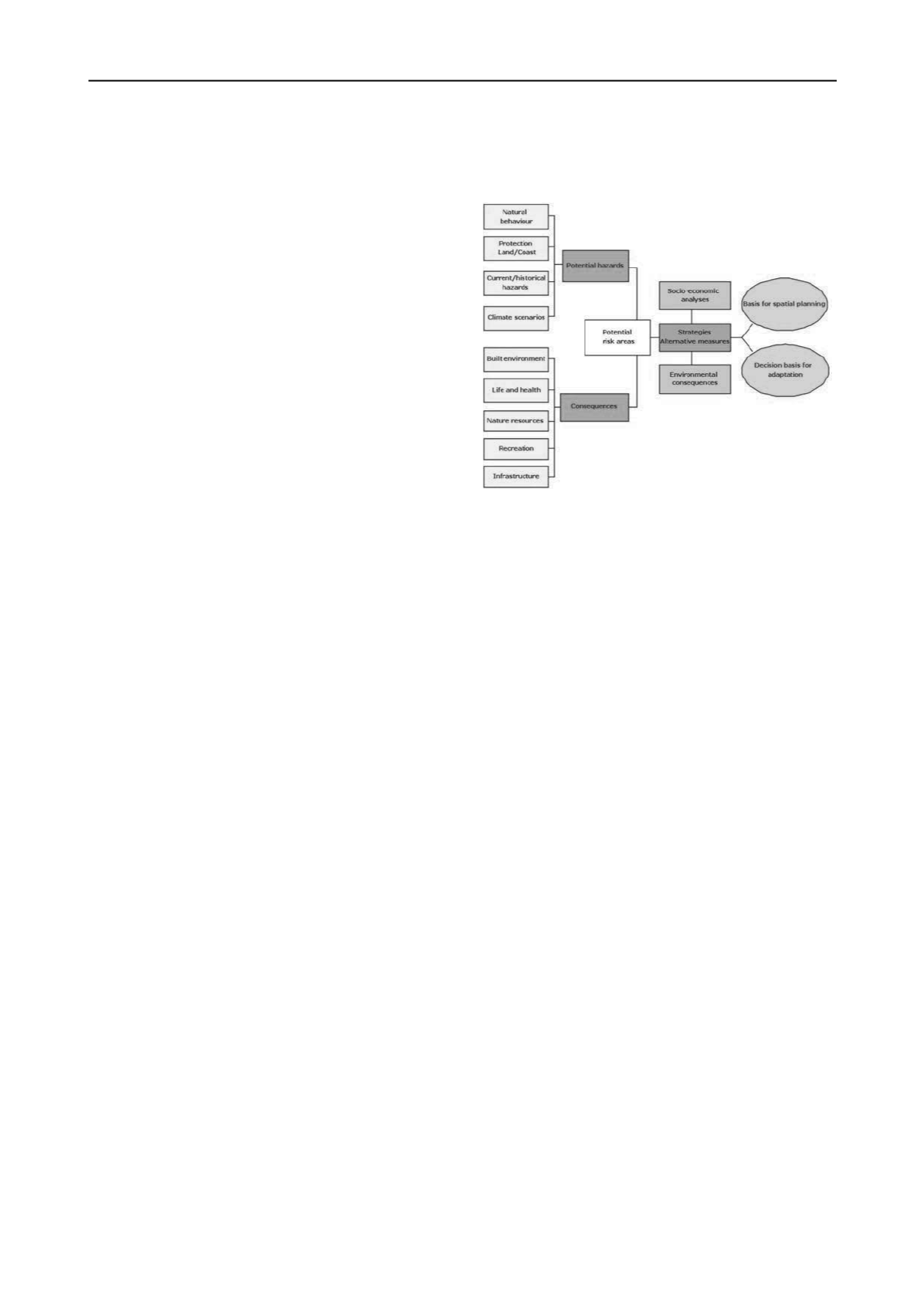
3 THE SGI DECISION PROCESS MODEL FOR NATURAL
HAZARDS
The SGI decision process model describes the potential risk
related to a particular natural hazard, and makes it possible to
establish a decision basis for spatial planning and climate
adaption of built-up areas [7].
The model is partly based on the results of the Interreg
Messina project [8] and the EU Life Environment Response
project [9]. The model is based on identifying the prerequisites
or probability for a natural hazard (P) combined with its
associated consequences (C) which will determine the risk (R =
PxC). The entire model can be used or only parts of it
depending on the situation. The model aims to provide
outcomes in the planning process that contributes to sustainable
development including risk, environment, economy and social
sustainability aspects as shown in Figure 1 [2].
At every stage in the decision process model (Figure 1),
more detailed tools/models or suggestions exists that help to
handle the questions that arise. For example under potential
hazards the output can be a hazard map, and under the stage
potential risk areas the output can be a risk map. Other relevant
tools for identifying and assessing risk mitigation strategies can
be databases or other information on previous experiences of
strategies including pros and cons. It could also be a description
on functionality and related costs for investment. In the long-
term perspective, it could also be more holistic assessments
such as life cycle and multi-criteria analyses. If there exists for
example a mapping tool/model in another country it can be used
instead of the one in this paper, and the other stages in the
decision process model can be used together with that method.
For possible measures in spatial planning, or for adaptation
of the built environment, socio-economic analyses and
environmental assessments could be carried out. National and
regional inventories of the natural hazards are necessary for
spatial planning, to get an overview of risk areas or making
priorities for preventive measures. At the local level the SGI
tool can be used as a base for spatial planning, decision making
of alternative measures in a municipality or at a specific
location. The tool can also be used before investments are made
in an area.
Figure 1. SGI decision process model.
Input to the model is for example Information on the site
specific natural behaviour conditions which determine events
that may lead to natural hazards. They can be topographical,
bathymetrical, geological, water and wind conditions as well as
vegetation. The high and low water levels in the sea and
watercourses are important to determine. For water courses, also
the streaming conditions must be estimated. These parameters
are important to consider also for new climate scenarios. Also
other input to the model has to be considered according to
Figure 1[2].
3.1 Mapping of potential hazards/Probability
The susceptibility as an indication of the
probability
of
hazards such as erosion, landslides and flooding can be
estimated. In Sweden, national overview investigations of
landslides, erosion and flooding are carried out and described
briefly below.
The Swedish
landslide hazard mapping method for fine
grained sediments
(clay and silt), is used in a nation-wide
programme for landslide risk reduction in built-up areas
administered by the Swedish Civil Contingencies Agency
(MSB). The mapping method is divided in several stages which
get more detailed and need more information for each stage.
Initially a pre-study is carried out, with the purpose to identify
sub-areas considered to be mapped. Thereafter, the mapped
areas are divided into areas with and without prerequisites for
initial slope failure. The next stage is to identify areas with
satisfactory stability based on overview assessment and areas
that need more investigations. The results are presented in a
susceptibility map with three different zones. Other information
of interest for slope stability, such as calculated sections, scars
of old landslides, erosion in progress and the presence of quick
clay can be shown on the same map [2, 10].
There is also a Swedish
landslide hazard mapping for till
and coarse soils
[2, 11, 12] administrated by MSB, divided in
stages in the same way. The susceptibility for landslides and
debris-flows in slopes is carried out based on a combination of
overview stability calculations (safety factor) and other
influencing factors. The susceptibility for debris flows in gullies
is based on already occurred debris flows and by mapping and
compiling factors that could contribute to triggering of a debris
flow. For both cases there is in general a combination of six
main factors: topography, hydrology, soil conditions, land use,
earlier soil mass movements and existing preventive
constructions. It is necessary to calculate the peak discharge,


