3250
Proceedings of the 18
th
International Conference on Soil Mechanics and Geotechnical Engineering, Paris 2013
the best available way to establish sustainable land and coastal
areas.
For the built environment, the decision makers will have a
proper and transparent basis for the discussion with different
stakeholders and the final decision of the best available way to
adapt built environment on land and in coastal areas.
4
EXAMPLE ON THE LOCAL LEVEL
The model or parts of the model has been used in several
climate and vulnerability analysis in Sweden, both on regional
and local level.
The municipalities have to make comprehensive plans and
detailed development plans, where risks for natural hazards
must be investigated. In order to consider the consequences of
climate change on the planned and existing built environment
SGI and Swedish Metrological and Hydrological Institute have
on behalf of Nynashamn municipality carried out an Overview
Climate- and Vulnerability Analysis as a basis for the Municipal
Comprehensive Plan 2010.
When working with comprehensive plans detailed data
normally is not available, so the evaluation was made of the
interface between areas with risk for natural hazards and
consequences for important society constructions. The aim of
the investigation was to clarify the consequences due to
increased rain fall and sea level rise for different scenarios.
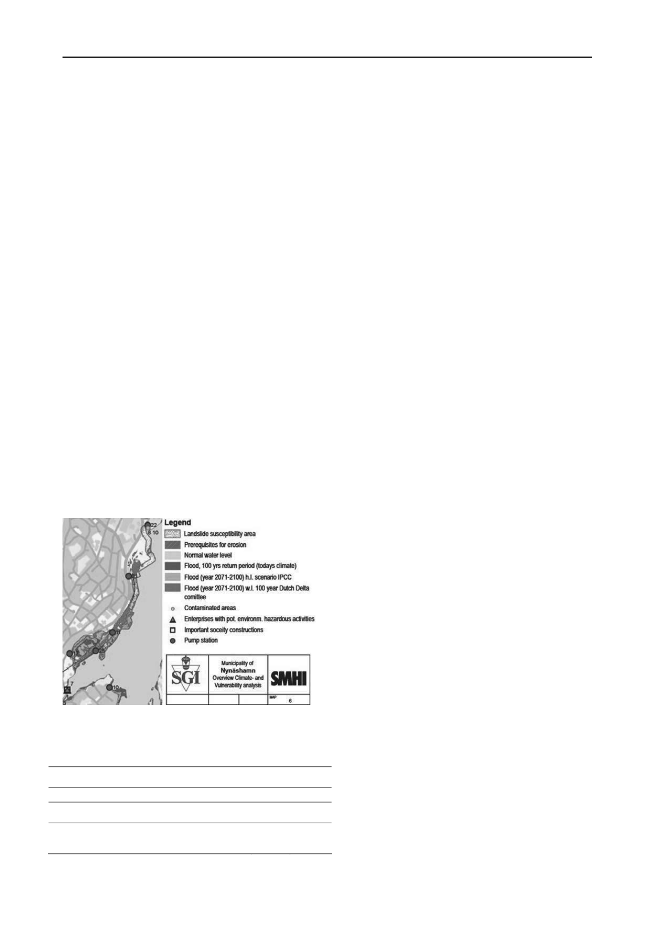
Areas with risks for flooding, landslides or erosion have been
investigated and the risk areas are illustrated in maps, see Figure
3. The interface between these areas and important society
constructions has also been shown. The constructions can be
e.g. special buildings, roads, railroads, dams. Environmental
aspects have to be considered for e.g. flooding or landslides in
contaminated areas or areas with enterprises with potential
hazardous activities or dangerous substances.
An example of such a map is shown in Figure 3. The
flooding from sea level rise is shown in the figure for different
scenarios and the levels are also shown in Table 1.
Figure 3. Part of Overview Climate- and Vulnerability Analysis for the
Municipality of Nynäshamn in Sweden [2].
Table 1. The sea level for determination of flood along the coast of
Nynashamn (given in meter in the Swedish height system RH00).
Case
Level
(RH00)
1. Flood, 100 years return period (today’s climate)
0.68
2. Flood calculated future (year 2071-2100) high
level scenario according to IPCC
1.30
3. Flood, future (year 2071-2100) water level with
100 years return period, according to the Dutch
Delta committee
1.71
As shown in the figure and table there can be rather
different results depending on which scenario that are used. It is
important to compare different scenarios and act for
uncertainties. Recommendations have to be suggested for
spatial planning. In built-up areas natural risks measures have to
be taken to prevent damages on constructions. Strategies and
measures are suggested, for example slope excavations, berms,
levees, coastal protection or other stabilising measures.
REFERENCES
1. The Baltic climate project, financed by EU Baltic Sea Region
Programme 2007-2013,
2. Rogbeck Y., Löfroth H. and Persson H. (2012) Baltic challenges
and chances for local and regional development generated by
climate. Swedish Geotechnical Institute, SGI. Varia 628,
Linköping.
3. Fish P.R., Moss J.L., Jakeways J. and Fairbank H. (2007)
Response: Applied earth science mapping for evaluation of climate
change impacts on coastal hazards and risk across the EU;
International conference on landslides and climate change.
Challenges and solutions, Ventnor, Isle of Wight, UK, 21-24 May,
2007.
4. The KULTU-Risk project,
5. The UKCIP tool website,
6. Bailles A., Vandromme R., Desramaut N., Sedan-Miegemolle O.
and Grandjean G. (2011) Changing patterns in climate-driven
landslide hazard: an alpine test site. World Landslide Forum, 2,
Rome, 3-7 October, 2011. Proceedings.
7. Rydell B., Persson M., Andersson M. and Falemo S. (2011)
Sustainable development of near-shore areas. Planning and decision
basis for prevention of natural hazards due to climate change. (In
Swedish). Swedish Geotechnical Institute. Varia 608. Linköping.
8. Messina (2006) Monitoring and modelling the shoreline. Messina
Component
2.
Results
from
the
Messina
study.
‐
messina.org (2007-07-19).
9. McInnes R. (2006) Responding to the Risks from Climate Change
in Coastal Zones. A good practice guide. Centre for the Coastal
Environment, Isle of Wight Council, United Kingdom.
(2008-03-26).
10. Fallsvik, J. (2007). Zonation and landslide hazard by means of LS
DTM - Deliverable 7, LESSLOSS - Risk Mitigation for
Earthquakes and Landslides Integrated Project. Swedish
Geotechnical Institute, SGI. Varia 578. Linköping.
11. Lundström K., Viberg L., Sundsten M., Andersson M, Fallsvik, J.
and Sällfors G. (2007) Overview mapping of stability and run-off
conditions in gullies and slopes in till and coarse-grained sediments.
Mehtod description (In Swedish). Räddningsverket. Karlstad.
12. Rankka K. and Fallsvik J. (2005) Stability and run-off conditions –
Guidelines for detailed investigation of slopes and torrents in till
and coarse-grained sediments. Swedish Geotechnical Institute, SGI.
Report 68. Linköping.
13. The SGI website,
14. Rydell B., Blied L., Hedfors J., Hågeryd A.C. and Turesson S.
(2012) Metodik för översiktlig kartering av risker för stranderosion.
(Methodology for overview mapping of erosion). (In Swedish).
Swedish Geotechnical Institute, SGI. Varia 641. Linköping.
15. Andersson-Sköld Y. (2011) Consequences of landslides in the Göta
river valley – Sensitivity analysis, classification and application of
the methodology throughout the study area. (In Swedish). Swedish
Geotechnical Institute, SGI. Göta River Commission. Sub Report
13. Linköping.
16. Andersson-Sköld Y., Falemo S., Suer P. and Grahn T. (2011)
Landslide risk and climate change – economic assessment of
consequences in the Göta river valley. European conference on soil
mechanics and geotechnical engineering, 15: Geotechnics of Hard
Soils - Weak Rocks, Athens, 12-15 September, 2011. Proceedings,
vol. 3, pp 1313-1318.
17. Landslide risk in the Göta river valley in a changing climate. Final
Report 2
–
Investigation conduct and methods. (In Swedish).
Swedish Geotechnical Institute, SGI. Göta River Commission.
Linköping.
18. Rydell B., Persson M., Rankka K. and Uytewall E. (2006)
Guideline for socioeconomic valuation of the shoreline. Coastal
innovations and initiatives, Littoral 2006, Gdansk, Poland, 18-20
September, 2006. Proceedings, vol. 1, pp 16-22.


