2752
Proceedings of the 18
th
International Conference on Soil Mechanics and Geotechnical Engineering, Paris 2013
2.2. Geology
Territory in close vicinity of the site is made up of different by
genesis and composition rock complexes (Chrischev, 1990):
Gornooryahovska Formation (gK1h-a). The Formation out-
crops have wide area. The unit builds lower parts of the terrain
and slopes of hills, crowned by a strong sandstone and lime-
stone cliffs on its cover. It consists mainly of gray-blue to dove-
gray clayey marl altered with some rare and thin layers of solid
calcareous sandstones and softer unsorted clayey sandstones.
Balgarenska Terrigenous Formation (bnK1b-a). In the
eligible area this formation consists of calcareous sandstones,
silty clays and marls, which in places pass into lime-clay
siltstones.
Emen Limestone Formation (eK1b). In Veliko Tarnovo
region the lower parts of Emen Limestone Formation are
presented. It is made of bio-detritus fine limestone, which are
revealed in the ridge parts of the landscape. The thickness of the
Formation is up to 200 m.
Quaternary diluvial and alluvial deposits are presented above
rocky basement. Deluvial deposits are composed of sandy clays,
coarse gravels and boulders. They are presented at the foot of
the slopes. In some places deluvial clays have considerable
thickness. Alluvial deposits build up fragments of first and
second terrace above the Yantra River. Alluvial sediments
include well graded gravels and sands and sandy clays.
The region belongs to the transitional zone between the
Moesian platform and Fore Balkan. Southern boundary of the
transition zone is traced unambiguously from Turnovo-
Zlatarishky fault. On the surface, it is marked by longitudinal
beam fractures, tearing sediments of Balvanska syncline.
Northern border passes along the most significant gradient of
facial changes and transitions sediment thickness formed during
Middle Alpine stage. The transitional nature of the area is
expressed in fold-block structure dominated by faults. The study
area falls within the scope of the Tarnovo anticline.
2.3. Climate
Investigated area characterized by moderate continental climate.
The average January temperature is -1 to -3,0° C and the
average July temperature 23-24° C. The annual rainfall is 550-
650 mm, with a minimum in February and a maximum in June.
The west and northwest winds predominate. In 2005, significant
rainfall exceeded the average monthly and annual rate (Table 1).
Table 1. Rainfall in the region before landslide (2005)
(
Month
Monthly
Rainfall, mm
Compared
Rate, %
05
113,3
138
06
148,7
179
07
212,2
322
08
90,0
141
09
236,6
538
10
47,8
126
Sum, 2005
1132,2
163
Precipitation in September was more than five times the
average monthly rainfall. This reflected in the runoff,
increase groundwater levels and the development of
physical and geological processes and phenomena.
2.4. Geo-dynamical phenomena and processes
Landslides, weathering, erosion and karst are developed in the
region. The presence of clayey sediments, very rugged terrain,
tectonic structures and hydro geological characteristics
determine the appropriate conditions for development of
different type landslides. Their appearance and activation is
caused by river erosion, increase groundwater levels,
earthquakes, undercutting the slopes by excavations and over-
loaded the slopes with large embankments (Glavcheva &
Dobrev, 2012).
The basic rocks are cracked and disintegrated at a depth of 5-
7 m under the action of weathering agents. The weathered rocks
are susceptible to sliding and erosion during high precipitation
and runoff. Karst is highly developed in the limestone cliffs of
Emen Formation and different caverns and caves are formed.
2.5. Methods of exploration works
The landslide was studied with 6 motor boreholes located in
three longitudinal profiles (fig. 2). Drilling depths were 9.20 m
to 12.00 m, depending on specific conditions. Dynamic probing
in 3 points was carried out to determine the thickness of the
Quaternary cover and landslide masses and for extending the
profiles.
Core drilling was performed, without casing, оn dry and
short trips. This technology was applied in order to obtain the
most reliable information about the boundaries of engineering
geological layers and determining slip surface of the landslide.
To characterize the physical and mechanical properties of soils
12 samples were taken.
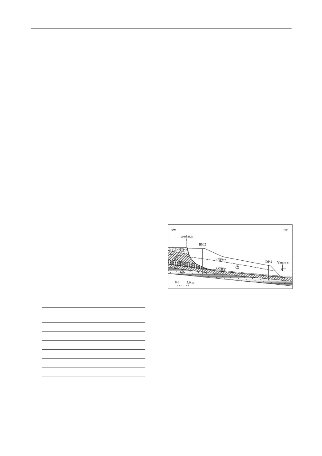
Figure 2. Engineering geological cross-section I - II
1 - road embankment; 2 - Quaternary diluvial clay; 3 - Quaternary
gravels with sandy-clayey filler; 4 - Lower Cretaceous marls; 5 -
Landslide masses; LGUT - lower ground water table; UGWT - upper
ground water table
2.6. Engineering geological layers
According to Genesis, lithological characteristics and physico-
mechanical properties of soils established in exploratory
boreholes, five layers were separated (Table 2).
Layer 1 - Embankment. The layer builds the road bed. Its
thickness is amended widely due to the slope of the natural
terrain. The layer is composed of medium to coarse well graded
gravel with a maximum thickness of 1.50 m on the coarse
rounded gravel with a sandy-clayey filler.
Layer 2 - Quaternary diluvial clay. The layer is located
below a layer 1, reveals the at the terrain surface or alternating
with layer 3. It is represented by brown, tan to variegated stiff to
firm clays with fine gravels. Large boulders up to 0.5 to 1.5 m
diameter are found in some places. The thickness of the layer is
between 4.70 m in borehole 5 (BH 5) to 9.20 m in BH 1.
Layer 3 - Quaternary gravels with sandy-clayey filler. The
layer is set below the layer 1 in BH 1 or alternating layer 2 at
different depths in the other boreholes. It is represented by


