26
Proceedings of the 18
th
International Conference on Soil Mechanics and Geotechnical Engineering, Paris 2013
Proceedings of the 18
th
International Conference on Soil Mechanics and Geotechnical Engineering, Paris 2013
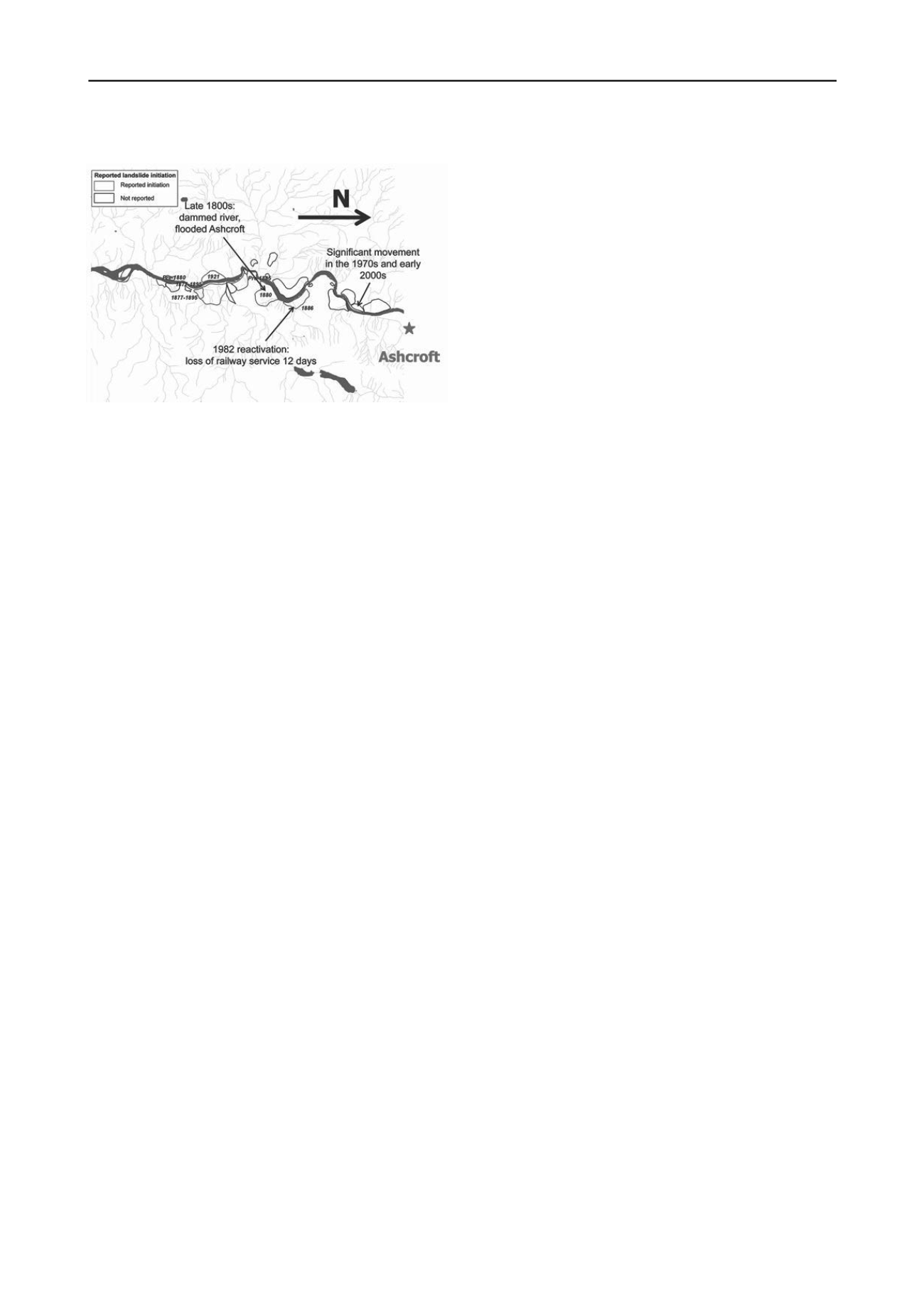
Figure 27. Reported landslide in Ashcroft area (Bunce and Quinn 2012).
8.2
Investigations
The soil consists of disturbed glacio-lacustrine clay and silt, and
the failure seemed to follow complex mechanisms with irregular
wedge formation. The geological and hydrogeological settings
were also complex, with alluvial fans and fractured bedrock
(Bunce and Quinn 2012).
The geotechnical investigation failed to identify a trigger for
increased movement. Given the long period of gradual move-
ment it appeared that the slope was in a alternating cycle of be-
ing unstable and stable due to erosion and or groundwater con-
ditions and small increments of movement.
As part of the planning of mitigation work and the man-
agement of the landslide activity and operative safety of the rail-
road, knowledge gaps were identified:
Subsurface conditions outside and between landslides.
Stress-strain behaviour of the materials involved in failure.
Realistic model for new or reactivated landslides.
Contribution of river drawdown, erosion and infiltration.
Erosion by the river.
Effect of weather and climate, and changes thereof.
Effects of topography.
What are the tolerable movement limits?
Local water balance.
8.3
Analyses of the slides
Some Ashcroft Thompson River landslides are known to have
moved at rates of several meters per day including the North
Landslide in 1881 (Stanton 1898) and the Goddard Landslide in
1982 (Fig.91). The Ashcroft Sub, Mile 50.9 Landslide and the
active portions of the North Landslide and the South Landslide
are known to be currently moving at rates of 10 to 30 mm year.
The causes of the landslides were multiple, and at times dif-
ficult to assess, which make the prediction of an oncoming
landslide as railroad traffic is planned very uncertain. The
causal factors include (Bunce and Chadwick 2012):
weak glacio-lacustrine silt and clay;
incision of the Thompson River;
upward seepage pressures;
low strength on pre-existing failure surfaces;
river level appears to exert a controlling influence;
infiltration from irrigation.
There was also relative little information on the success
and/or failure of past remedial measures.
8.4
Risk management
Bunce and Martin (2011) developed a procedure to manage the
railroad risk associated with landslides. Factors considered in-
cluded the magnitude and frequency of landslide activity and
the rate of ground movement compared to the frequency of
track maintenance.
The impact of the failures was multi-faceted. In addition to
the costs to the Canadian economy, the negative aspects in-
cluded: potential for injury and death of locomotive operator
and conductor, the impact on the environment, consequences of
a derailment including the fate of the freight material, a pro-
longed service interruption resulting in a loss of Canada’s
credibility as a reliable exporter, damage to key fisheries, im-
pact to First Nations land claims, damage to adjacent land-use
and irrigation for agriculture, flooding, damage upstream and
downstream of the landslide.
For the Ripley Landslide, since the track speed was 30 mph
with no potential for a derailed locomotive to reach the river,
the probability of a fatality was estimated as extremely low. The
Ripley Landslide was known to be moving at a gradual rate that
had had no influence on the safe operation of the railway for
more than 60 years. The frequency of normal railway mainte-
nance was sufficient to periodically realign the track such that
the track speed could be maintained without compromising the
safety of rail operations, despite periods requiring more frequent
track maintenance.
From an economic perspective the Ripley Landslide was
costing the railways a minimal amount of maintenance and little
or no reduction in operating efficiency. The primary successful
landslide mitigation measure of the other landslide locations
was the placement of an erosion-protection toe-berm of rip-rap
into and along the river bank. However, although the cost of this
method was attractive compared to other options the environ-
mental, especially fisheries impact was considered significant.
In the case of the Ripley Landslide, CP assessed its options
and given that the effectiveness of stabilization was uncertain
and costly, and the risk of catastrophic failure based on past per-
formance of this landslide was low, a monitoring system was
selected.
The advantages of this concept were: the risk to train traffic
was minimized; the cost was less than the least costly stabiliza-
tion measures; the environmental impact was negligible in com-
parison to completing in-river works; and additional informa-
tion about the behaviour of the landslide in response to external
changes could be further investigated to identify means of stabi-
lizing the landslide in the future if movement rates increase
above tolerable levels. These advantages were offset by the dis-
advantage that although rail safety is ensured the reliability of
the transportation system remains the same.
In view of the uncertainties and the overwhelming extent of
the potential consequences, CP invested in research and moni-
toring.
The research investment included a Railway Ground Hazard
Research Project (
), multi-year research grants
and support for PhD and MSc studies on rock fall, landslides,
climatic triggers, debris flows and risk analysis, a rail research
laboratory (
) and strategic research partnership
with universities, research organizations, and stakeholders.
CP installed in 2008 a real time permanent Global Position-
ing System (GPS) on the Ripley Landslide located about 7.5 km
south of Ashcroft to monitor ground movement and provide no-
tification of significant track movement (Bunce and Chadwick
2012). The Ripley Landslide was known to have moved ap-
proximately 70 mm per year between 2008 and 2011. In view of
(1) the high cost to stabilize 400,000 m
3
of soil, (2) the envi-
ronmental implication of attempting to stabilize the landslide
without negatively changing the fishery in the Thompson River
and (3) the uncertainty on the effectiveness of potential stabiliz-
ing measure; the decision was taken to monitor and respond
rather than stabilize the landslide.


