23
Terzaghi Oration
/ Allocution Terzaghi
Proceedings of the 18
th
International Conference on Soil Mechanics and Geotechnical Engineering, Paris 2013
was sub-horizontal. The slip surface was detected Elevation 2.5
m below the Salvail river bed (originally at Elevation 6 m) for
the first two-third of its length. The last third of the slip surface
was at Elevation 15 m near the scarp. These two levels of the
failure surface explain the overlapping of blocks in the central
part of the scar.
Figures 20 and 21 and Table 9 present the results of a few of
the stability analyses. Only the most critical of the 1000’s of
slip surfaces are shown. Analyses under drained and undrained
conditions were run. The analyses were run with the SEEP/W
and SLOPE/W code (GeoStudio 2007 verG7.17; GeoSlope In-
ternational).
For the case of drained conditions (Fig. 20), the computed
factor of safety (FS) was 0.98 with the Bishop method and 1.03
with the Morgenstern-Price method. The lower part of Figure 20
shows the area of all the circles giving a factor of safety of 1.05
or less. All critical slip surfaces pass below the river bed, which
agrees with the observations after the slide.
For a failure surface extending significantly up slope (hori-
zontal distance of 80 m in Fig. 21), the factor of safety was
about 1.3, showing that this was not the triggering rupture
mechanism. For undrained conditions (Fig. 21), using the ob-
served slip surface, the safety factor was about 2.3.
Table 9. Results of stability analyses of St-Jude landslide.
Case
Slip surface
Method
FS
Circular
Bishop
0.98
Drained
(Fig.54)
Horizontal
Morgenstern-Price
1.03
Circular
Bishop
3.1
Drained
Entire slope
Horizontal
Morgenstern-Price
3.3
Circular
Bishop
2.2
Undrained
(Fig.55)
Horizontal
Morgenstern-Price
2.3
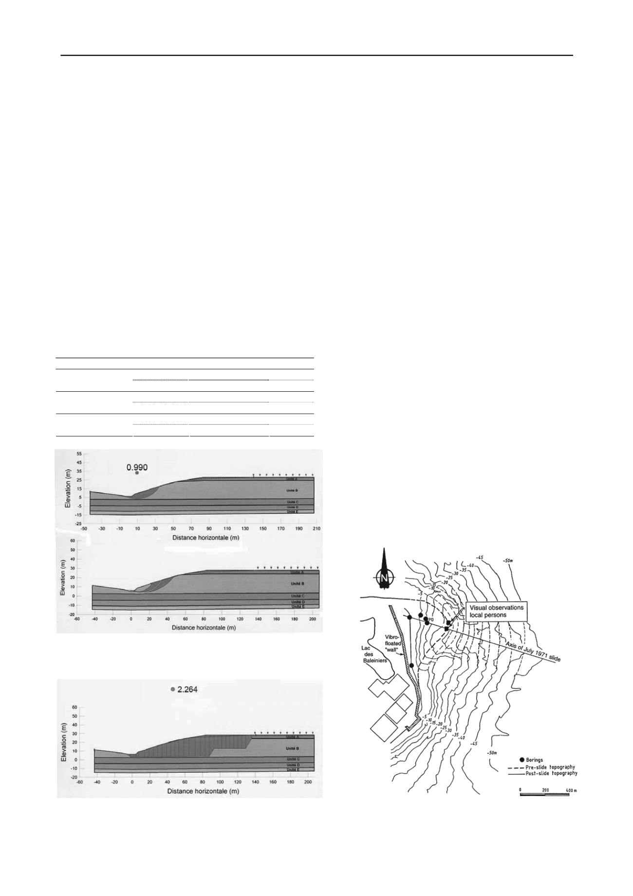
Figure 20. Results of limiting equilibrium analysis of St-Jude landslide
under drained conditions: top: Bishop method, critical slip surface; bot-
tom: All slip surfaces giving Factor of safety ≤ 1.05 (Locat
et al
2011).
Figure 21. Results of limiting equilibrium analysis of St-Jude landslide
under undrained conditions: Morgenstern-Price method, observed slip
surface (Locat
et al
2011).
6.4
Lessons learned
The high pore pressures in the clay below the river bed resulted
in very low effective stresses, and therefore low resistance in
the clay.
The conventional analysis of the failure with circular slip
surface gave a safety factor of unity under drained conditions,
but could not explain the observed extent of the slide. Locat
(2007) and Locat
et al
(2008) made similar observations.
The trigger of the landslide is believed to have been of natu-
ral origin. The stability was impaired by (1) the high artesian
pore pressure at the toe of the slope and (2) shoreline erosion,
also at the toe of the slope. Since the meteorological conditions
did not show any heavy rainfall at the time of the landslide, the
trigger of the movement was probably the continuous erosion of
the toe, which had aggravated over the last 15 years.
The failure probably occurred in two stages, the first a rota-
tion, thereafter a translation, as suggested by the post-failure
grabens and the horsts (Fig. 18). The movement stopped when
the debris accumulated on the other side of the river bank gen-
erated sufficient resisting forces to re-establish equilibrium.
As mitigation in Saint-Jude on the Salvail River, the height
of the natural slope was reduced to a maximum of 10 m, the
river was moved about 60 m further away from the road and the
debris were left in the landslide scar.
7 RECURRENT SLIDING ON CAP LOPEZ
7.1
Description of the landslide
On Cap Lopez in Gabon, a large underwater slide took place in
July 1971. Twenty years later, the coastline had same topography
as in July 1971. It was important to assess whether sliding would
recur, as adequate safety was required for the oil terminal installa-
tions on land.
Pointe Odden in Gabon is known for its rapidly changing
coastline due to complex erosion and sedimentation patterns,
enhanced by the presence of a deep submarine canyon on the west
side. A 3,000,000 m³ slide took place on Cap Lopez’ north end,
called Pointe Odden in July 1971 (Fig. 22). Figure 23 shows some
of the coastline movements since 1911.
Figure 22. Topography before and after 1971 slide (Lacasse and Boisard
1996)


