25
Honour Lectures /
Conférences honorifiques
Proceedings of the 18
th
International Conference on Soil Mechanics and Geotechnical Engineering, Paris 2013
On the one hand, among the «negative» factors:
‐
The slope between Pointe Odden and Quai des Chalands
consists of young sediments with frequent and seasonal
changes in the shoreline.
‐
The sediments south of the 1971 slide may be in a state of
unstable equilibrium. The addition of a small quantity of sand
can result in important surface sliding.
‐
The slopes of the seabed have an inclination prone to sliding;
continuous weaker layers susceptible to slides may be present.
‐
The large surface slide in 1988-1989 did not preclude the
possibility of the occurrence of a large deep-seated slide.
‐
A deep-seated slide may be triggered by an accumulation of
sand, erosion (e.g. discharge of an outflow pipe or wave
action) or some local small vibration in the earth crust.
On the other hand, among the «positive» factors:
‐
The Quai des Chalands area appears to have no history of
sliding, except between 1937 and 1946.
‐
The efficiency of the vibro-floated wall to stop a slope failure
is not known. However observations during the vibro-floating
operation indicated a very strong soil at the bottom of the
vibro-floated area, where the cone penetrometer could not
penetrate. With such layer beneath the vibro-floatation zone,
the possibility of a slide going further inland should be low.
‐
Movements experienced during pile installation were not an
indication of foundation instability, but were probably caused
by the piling procedure used.
‐
The sheet pile driving near the Quai des Chalands did not
trigger slides at the time of pile installation.
An impact study was made to select the optimum solution for
the continued operation of the oil terminal. The following
consequences were considered: (1) loss of life, and loss of Pointe
Odden to sea; (2) impact on environment due to damage of loading
berth and oil leakage; (3) undermining of sand foundation at Quai
des Chalands; (4) displacement of pile tops and anchors of the
pier; (5) reduction of draught near the pier and Quai des Chalands;
(6) impact on oil terminal activities. Remedial measures and their
feasilibity were also considered: (1) on-site geotechnical
reconnaissance and laboratory testing on soil samples; (2) careful
dredging (difficult to achieve without triggering a slide, and not a
permanent solution); (3) deep underwater compaction (e.g. vibro-
floatation, chalk piling, grouting, chemical injection; (4) controlled
blasting of the underwater slope.
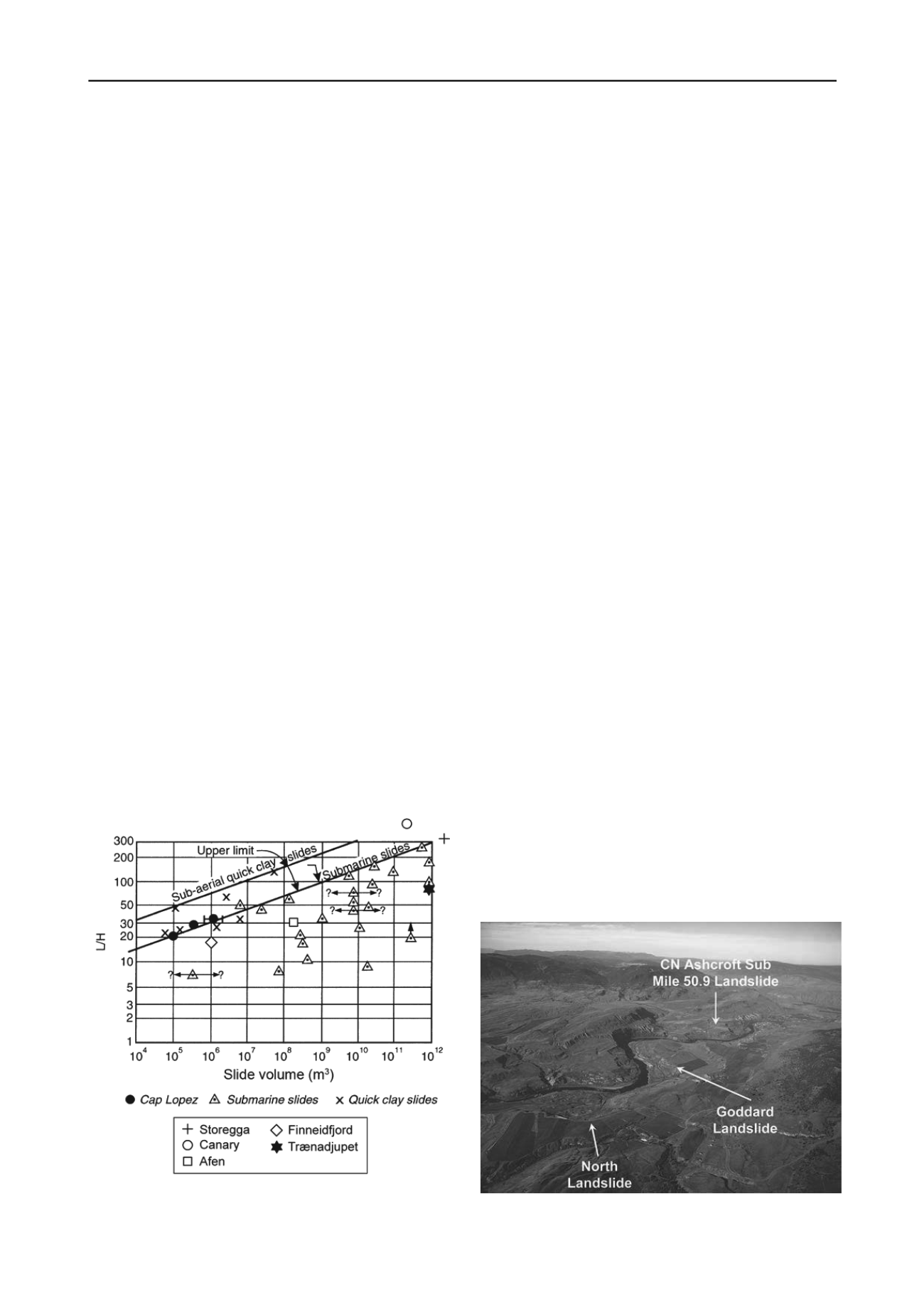
Figure 25. Run-out distance
vs
slide volume for submarine slides
(Edgers and Karlsrud 1982; additional data from Canals
et al
2005))
7.4
Lessons learned
The slides seemed to occur every 15 to 20 years. They are a natural
phenomenon due to the geology and geography of the area. For
such natural hazard, given the impact analysis carried out and the
uncertainty whether remedial measures would be partly or fully
successful, continued surveillance of the coast and seabed, using
the slope of the seabed as stability indicator, was deemed the
optimum solution.
The sliding on Cap Lopez was difficult to circumvent. In view
of the sliding observations in the past, the fact that recent sliding
occurred within the limits of the «worst case» scenario of the
impact study, the positive and negative factors that could lead to
sliding near the terminal installations, Elf made the engineering
decision to continue surveillance of the coast and seabed, using the
slope of the seabed as indicator of stability. This decision was
helped by the fact that the risk of loss of human life was essentially
nil. The overall risk to the oil terminal operations was considered
to be tolerable with surveillance of the coast as the main tool to
evaluate whether new remedial measures were needed.
8 THE ASHCROFT THOMPSON RIVER LANDSLIDES
8.1
Description of the landslides
The town of Ashcroft is located on the east side of the Thomp-
son River in southern British Columbia, northeast of Vancou-
ver. The multiple landslide activity near Ashcroft has a very
strong impact on freight transportation. (Bunce and Chadwick
2012; Bunce and Martin 2011; Bunce and Quinn 2012).
Figure 26 presents an aerial view of part of the Ashcroft
Thompson River and three recent landslides. Near the village of
Ashcroft, more than 20 landslides have occurred, ranging in size
from 10,000 m
3
to 5 million m
3
. Figure 27 illustrates some of
the reported landslide initiations and observed significant
movements near the railway in the Ashcroft area. The move-
ments can be slow and relatively small, but insidious, or they
can be sudden, fast and very large.
The stakeholders are the railway companies, Canadian Pa-
cific and Canadian National, Transport Canada, the British Co-
lumbia Government (Environment and Transportation) and the
Canadian Department of Fisheries and Oceans. Railways trav-
erse valley slopes and can be exposed to numerous landslide
hazards. Railways typically select one of three strategies to
manage the risks associated with landslides: avoid the landslide,
stabilize the landslide or implement monitoring and signal sys-
tems that indicate when the tracks may be unsafe (Bunce and
Martin 2011).
Figure 26. Ashcroft Thompson River and three recent landslides (Bunce
and Quinn 2012)


