21
Terzaghi Oration
/ Allocution Terzaghi
Proceedings of the 18
th
International Conference on Soil Mechanics and Geotechnical Engineering, Paris 2013
sensitive clay. Geological investigations of the rock also indi-
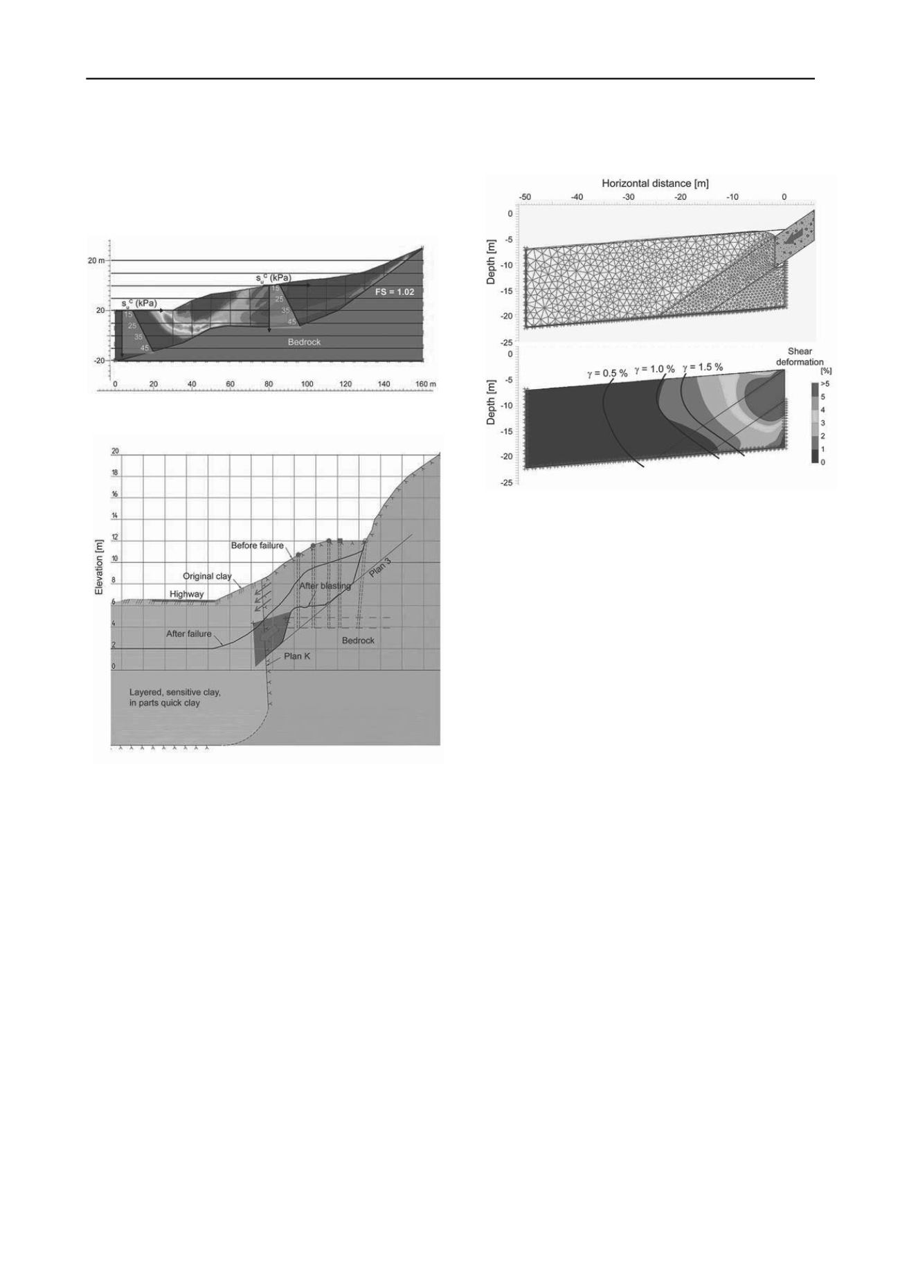
cated the following (Fig.15): a nearly vertical weakness zone in
the bedrock (Plan K); a fault at an angle of 36 º inclining to-
wards the clay (Plan 3) acting as sliding plane for the rock under
blasting; and other weakness planes in the rock mass contribut-
ing, with Plan 3, to pushing the rock face into the quick clay.
Figure 14. Results of stability analyses before blasting, cross-section in
Zone 3, Kattmarka landslide (Nordal
et al
2009).
Figure 15. Cross-section in Zone 1 at the time of blasting, Kattmarka
landslide (Nordal
et al
2009).
Nordal et al 2009 did analyses of the shear strain (
) in the sen-
sitive clay as the rock mass detached by the blasting penetrated
the clay. Figure 16 illustrates one of the results. With the finite
element mesh in the top part of the figure for the PLAXIS dy-
namic analysis, the blasting was modeled by a penetrating ele-
ment with a maximum velocity of 10 m/s and a total displace-
ment of 0.5 m into the clay. Equivalent linear properties were
used in the clay for this calculation. The bottom cross-section in
Figure 16 illustrates the shear strain contours. Liquefaction was
believed to occur when the shear strain is greater than 3%.
The slide was triggered by the blasting. The blasting moved
the rock face and a block pushed outward into the clay with
considerable force and velocity, causing the surrounding clay to
liquefy. The unexpected movement of the rock face was a con-
sequence of two unfavourable conditions: (1) the a priori un-
known orientation of the rock-clay interface and (2) planes of
weakness in the rock mass. The sensitive quick clays, however,
had already before construction a marginal stability. The devel-
oper did not know of how critical the stability was.
5.3
Lessons learned
The slide had dramatic consequences, and it was just a matter of
good odds that no lives were lost. Many parties were involved
in the planning, design and building process: the Namsos mu-
nicipality, the Norwegian Public Road Administration, the geo-
technical consultant and the contractor building the road.
Figure 16. Modeling of effect of blasting in clay sediments in Kattmarka
(remoulded clay in red and yellow zones) (Nordal
et al
2009).
The Namsos municipality introduced in 2003 the following
regulation: before approval of building plans, geotechnical
documentation shall confirm that the stability is acceptable and
shall not be impaired. This was not done for the road project in
2009.
No geotechnical investigation was carried out at the site be-
fore detailed planning. This was partly due to budget limita-
tions. Although it is acceptable for stakeholders with consider-
able local experience to work on the basis of their wide
knowledge in a region, the developer should have stopped the
building activities to do site investigations when soft clay was
found close to the road during the preparation for the blasting.
The geotechnical consultant was hired to study the stability
of the slopes in surrounding areas of the project and not in the
areas of Kattmarka, and his work had been limited to 80 hours.
The consultant had indicated the stability problem at the Katt-
marka location, but the proposed actions were not followed up.
The stability of the area of road construction was not analysed,
although this is required by the NVE (2011) regulations.
The Kattmarka landslide led to new regulations and an in-
creased focus on existing regulations, including:
the control and mapping of the clay-rock interface when
blasting in marginally stable areas;
the requirement for geotechnical investigations early in the
project planning process; and
the necessity for hazard and vulnerability analyses for pro-
jects that can endanger life and property.
6 THE SAINT-JUDE LANDSLIDE
6.1
Description of the landslide
In the evening of May10, 2010, a large landslide occurred in the
municipality of Saint-Jude, northeast of Montréal, in Québec,
Canada (Locat
et al
2012). The landslide happened without
warning on the right bank of the Salvail River, and tragically
took four lives. The landslide swept away the road, aqueduct
and power and telephone lines. Figure 17 presents a photograph
of the landslide and the location of the bed of the Salvail River
completely blocked by the landslide.
The plain at the top of the natural slope before failure was at
an elevation of 28m, and the slope inclination was between 12


