24
Proceedings of the 18
th
International Conference on Soil Mechanics and Geotechnical Engineering, Paris 2013
Proceedings of the 18
th
International Conference on Soil Mechanics and Geotechnical Engineering, Paris 2013
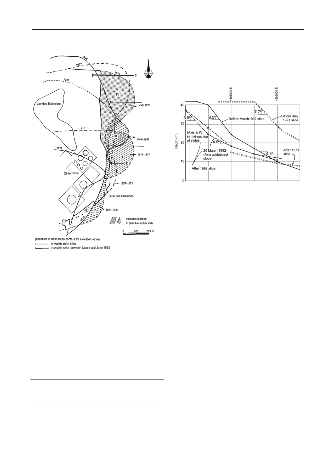
Figure 23. Observations of Cap Lopez 1911-1971 (Lacasse and Boisard
1996).
Witnesses to the July 1971 slide reported that the slide started at
02:00 in the night and continued until noon the next day. Land
extending about 310 m into the sea disappeared, moving about
1000 m away into deeper water. The slide had typical funnel and
fan shape often associated with flow slides. Surface sliding of a 3
m thickness over most of the seabed east of Pointe Odden occurred
between 1988 and 1989. The slopes before sliding had an
inclination between 8 and 9°.
Between 1989 and 1992, the coastline did not move
significantly. In March 1992, a new large slide occurred. At its
deepest, the 1992 slide was 10-12 m deep and extended 350 m in
the east direction. The 1971 slide was 30 m deep and extended
1000 m out to sea. Figure 24 illustrates the cross-sections before
sliding in the interval between the 70s and 90s.
The observations of the coastline (Fig.23) suggest recurrent
sliding, perhaps every 15 to 20 years as indicated in Table 8.
Table 8. Periodicity of slides on Cap Lopez
Approx. Date
Event
Time between events
1911-1920
1930-1937
1946-1957
1971
1992
Slide (?)
Slide (?)
Slide in 1957(?)
Slide
Slide
--
15-20 years
15-20 years
15-205years
21 years
Elf Gabon took measures to protect the coastline. On the west
side of the cape, protection walls were built every 25 m at
frequent time intervals since the 50s to stop erosion and sand
transport. From the Quai des Chalands to Pointe Odden on the
east coast, a vibro-floated "wall" was built (Fig. 22). The "wall"
is a 10- m deep, 20-m wide zone of compacted sand, placed to
stop the propagation of a slide. In 1979, dredging was carried
out at the east side of Pointe Odden to remove sand down to 9-
12 metres below sea level. The surface sliding however appeared
to have a self-remediating effect. Elf opted to monitor whether this
auto-regulation was sufficient to keep the coast stable in the future.
Figure 24. Underwater cross-sections before sliding (Lacasse and
Boisard 1996)
7.2
Soil parameters
The sand of Cap Lopez is a fine to medium coarse, mainly quartz,
sand. The grain size distribution falls within the limits established
in the literature for flow slide materials, and is similar to the grain
size of sands which have experienced flow slides. Consolidated-
undrained triaxial compression tests on sand sampled on-shore on
Pointe Odden show that the sand in a loose state has a contractive
behaviour with considerable strain-softening at low shear strains.
Cone penetration tests suggested that layers with very low density
or very low shear strength can be present.
7.3
Analysis of the slide
Stability analyses considered both a drained situation and an
undrained situation with development of excess pore pressures.
The slides seem to have been triggered by a small increase of shear
stress in a layer of looser/weaker material. The slide of March
1992 suggested that only a small additional amount of sand or a
small change in pore water pressure was sufficient to trigger a
large slide. On the basis of over 70 observations since 1971, the
limiting inclination of the slope was 8-9°. Slopes less than 8° were
always stable, slopes greater than 9° slid.
Edgers and Karlsrud (1982) studied the mechanisms of subma-
rine slide run-out with case studies. Figure 25 presents run-out dis-
tance as a function of the sliding volume. Observations for Cap
Lopez are added to the graph, as well as a number of larger un-
derwater slides that have been mapped in recent years (Canals et al
2004). The Cap Lopez slides plot at the limit of the underwater
slides. The existing data show that (1) submarine slides may be
triggered on very flat slopes; (2) the volume and run-out of subma-
rine slides are by far greater than the volume of terrestrial slides;
(3) the most predominant soil types with large run-out distances
were fine sands and silts; (4) a trend for increasing relative run-out
distance (run-out distance L over height drop H) with increasing
slide volume. The Cap Lopez data follow this trend.
A worst case scenario would be a deep-seated slide, ex-
tending close to the Quai des Chalands, and partly through the
oil loading berth, causing environmental damage, affecting op-
eration of the harbour and terminal, and requiring stabilisation
of dangerous slopes after the slide. The "worst case" estimate
was based on a series of “positive” and “negative” factors.


