3116
Proceedings of the 18
th
International Conference on Soil Mechanics and Geotechnical Engineering, Paris 2013
0 20 40 60 80 100 120
Degree of Saturation Sr (%)
深度GL- (m)
Degree of Saturation
(
dry season
)
Ground Water Level
(
dry season
)
Degree of Saturation
(
rainy season
)
Ground Water Level
(
Rainy season
)
0 10 20 30 40 50 60
Water Content
w
(%)
Water Content
(
dry season
)
Ground Water Level
(
dry season
)
Water Content
(
rainy season
)
Ground Water Level
(
rainy season
)
0
1
2
3
4
5
6
7
8
9
10
11
12
0.0
1.0
2.0
Water
・
Dry
・
Wet Density (g/cm3)
DepthGL- (m)
Wet Density
(
dry season
)
Dry Density
(
dry season
)
Water Density
(
dry season
)
Ground Water Level
(
dry season
)
Wet Density
(
rainy season
)
Dry Density
(
rainy season
)
Water Density
(
rainy season
)
Ground Water Level
(
rainy season
)
Clayly Sand
and
Sand and Grabel
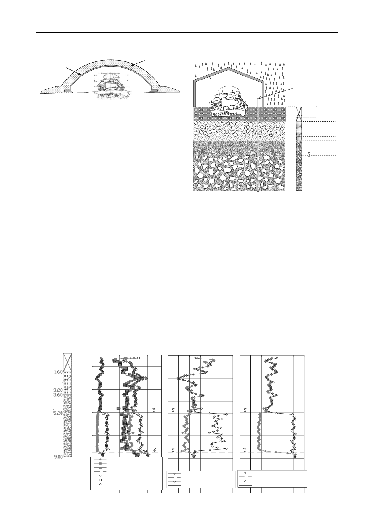
rain
1.60
temporary cover hut
observation well
G.L.
3.20
3.60
5.20
9.00
Sand and
Grabel-Bolder
Embankment
stone chamber
Sand
igure 2. Schem
F
Tu
whose diameter and height is 18 m and 6 m respectively. The
restored earth mound will be constructed with a diameter of
about 25 m based on the archaeological knowledge.
rature inside the stone chamber
caused by the solar radiation.
season when the groundwater level heightens due to sufficient
rainfall as well as in a dry season when the groundwater level
lowers. As far as the condition at the investigation is concerned,
the temporary shelter structure was equipped to cover the stone
chamber to avoid rainfall. The stone chamber was however not
completely free from the infiltration of water through the
surrounding ground.
According to the boring log, the subsurface condition of the
Grandoya Tumuli is as follows: The artificial fill consisting of
fine grained soil with gravel appears from the ground surface to
GL-1.6 m underlain by the clayey sand with gravel and boulder
from GL.-1.6 m to -3.2 m. The sand layer is found from GL-3.2
m to -3.6 m underlain by the sand and gravel from GL.-3.6 m to
-5.2 m. Then the gravel and boulder deposit appears from GL-
5.2 m to -9.0 m. Because the clayey sand above GL-3.2 m is
expected to have a low permeability enough to hinder
infiltration into the ground, the water by rainfall is expected to
exude inside the stone chamber.
The measured results of the density and moisture logging are
shown in Fig. 4. The groundwater level is found to change at
G.L. -5.04 m in the rainy season and G.L.-8.45 m in the dry
season. It is natural that the degree of saturation is kept almost
atic view of the restoration plan for the Garandoya
mulus
Figure 4 Measured results of the density and moisture content of the foundation ground at the Garandoya Tumulus
Figure.3 Cross section of the foundation of the Garandoya Tumulus
Earth mound
Cover structure
Stone Chamber
2.2
Examination subjects
Degradation of the colored paintings drawn on the surface of the
chamber stone is most greatly subject to the influence of
moisture. Development of the water resistant structure is
required to prevent dew condensation and intrusion of water
into the stone chamber. The possible phenomena to be
considered are 1) the underground water exudation from the
foundation, 2) the leakage of water from the joint of the
reinforced concrete panel of the shelter building, 3) the inflow
from surrounding ground. Technical procedures to overcome
the above-mentioned problems have to be discussed together
with the control of the tempe
3 INVESTIGATIONS OF MOISTURE IN THE GROUND
In order to consider the seepage of groundwater from the
ground, the condition of groundwater was investigated in the
observation well that is made from a vinyl chloride pipe with
outer diameter 60 mm and inner diameter 52mm (Figure 3)
currently installed in the nearest to the tumulus. The inserted
type RI densimeter and moistmeter of the shape of a pillar stick
of 42.7 mm in diameter and about 1000 mm in length is applied
to detect the moisture content as well as the density of the
ground. The RI densimeter and moistmeter is inserted to the
bottom of the well at the depth of 9 m from the ground surface
followed by conducting the scanning logging by pulling up at
the rate of 1 m/min. Investigation was conducted in a rainy


