3113
Technical Committee 301 /
Comité technique 301
The reason is change of water level and suction pressure. In
dry season, the underground water drops around WT=GL-5m
and rises to the ground surface during rainy season. The top of
ground surface of a few meters in thickness has effects of
seasonal change of the underground water.
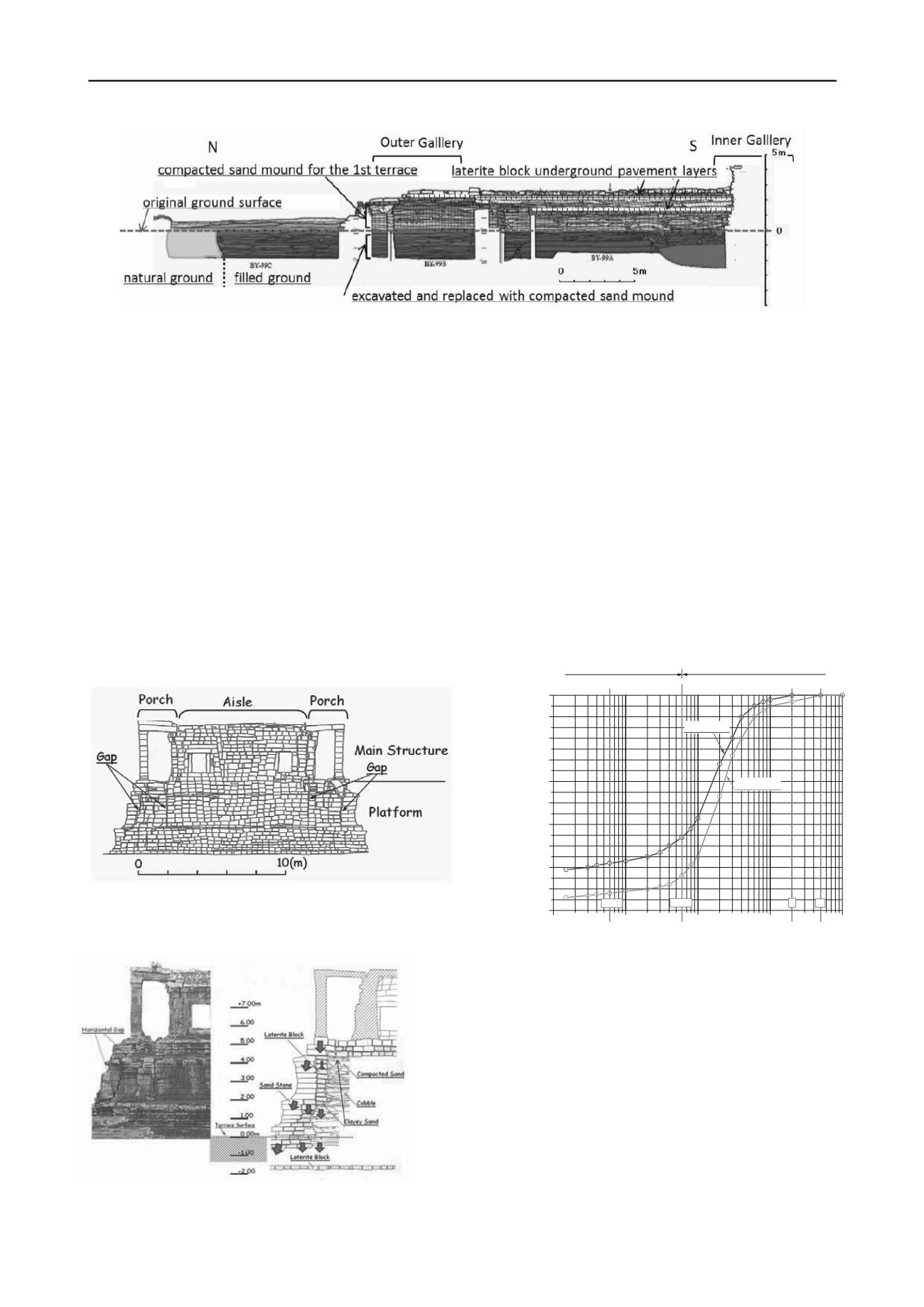
To study foundation system, JSA (Japanese Government
Team for Safeguarding Angkor) carried out a long trench at the
north western corner as shown in Figure 5, which shows plan
and section of Bayon, the central temple in the Angkor Thom.
The trench starts from the north edge of inner gallery
extending to north including the lowest terrace and outer gallery
until the natural original ground. The original ground was found
about 10m from the north edge of the Outer Gallery as shown in
Figure 6. The lowest terrace between Inner and Outer Gallery
was excavated until the natural soil layer was found. Based
upon the results of archaeological excavation, ancient Khmer
engineers excavated 2-3m from the ground surface in the
construction area including additional outer area of 10m in
width before the construction.
Figure 7. Vertical side view of Northern Library, Bayon
Figure 8. Trenched section at west end of Northern Library
Figure 6. Long trench at north side of Bayon in N-S direction (Narita,2000)
The excavated area was filled to the original ground surface by
sandy soils with dense compaction. Additional mound of about
2.5m was further compacted in the area of the lowest terrace.
Within the lowest terrace, two layers of laterite block pavements
were identified beneath the surface sand stone of the mound and
at the depth of 1.5m below the surface.
JSA dismantled the Porch part of Northern library, Bayon
before reconstitution of the Library as shown in Figure 7. Some
vertical gaps are noted in the side sand stones beneath the porch
section. These gaps look like to be caused by sliding of the edge
part caused by the load of the upper structure of Porch.
Excavated section is shown in Figure 8. The plat form of
the library consists of main body of compacted sand mound
with 5m in height surrounded by retaining wall of laterite blocks
in side with sand stones outside surface of the wall.
The clayey sand was found at a boundary between main
body of sandy soil mound and laterite blocks as well as at top of
the mound beneath the pavement of laterite block and sandstone.
The clayey sand is estimated as to prevent water infiltration into
the main mound (JSA, 2000).
1E- 3
0.01
0.1
1
10
0
10
20
30
40
50
60
70
80
90
100
(mm)
0.006 0.06 2 5
coarse soil
fine soil
Clayey Soil
Sandy Soil
Weight Percent passing(%)
0.001
Grain Size(mm)
Clay Silt Sand Gravel Cobble
0.006 0.06 2 5
Figure 9. Grain size distribution for sand and clayey soils for
mound
Figure 9 shows grain size distribution curve for these sand and
clayey soils used for filled mound in Angkor.
There is no evidence of sliding along the gaps on side stones.
The setting of the stone, laterite block, and compacted sand
layer is shown in Figure 8 with estimated flow of the load of the
upper structure to the foundation system. The load of the upper
structure is supported by laterite blocks and sand stones at +4m
in height, sand stones, laterite blocks, and compacted sand at
+2m and +0m in height. The direction of these forces is always
towards vertical or outwards. Khmer engineer seems to have
treated these different materials as to show the same characters.
The gaps are considered to be caused by the tendency of
horizontal outwards of forces as well as horizontal expansion of
compacted soils.


