2292
Proceedings of the 18
th
International Conference on Soil Mechanics and Geotechnical Engineering, Paris 2013
4 CONCLUSIONS
Dataset
Data acquisition
Potential landslide area ()
Landslide susceptibility
map
Depth of top soil (m)
Soil classification map
Possible sediment area ()
Field survey, DEM
Mean slope gradient of flow path(
°)
Field survey, DEM
Watershed area()
GIS tool, DEM
Rainfall(mm)
AWS
Bedrock type
Geological map
Mean flow distance(m)
GIS tool, DEM
A series of debris flow events occurred around 8:00 to 8:50 a.m.
on July 27, 2011 in the Umyeon Mountain area located in
Seoul, Korea. Field survey on the debris flow at Umyeon
Mountain was carried out to understand the comprehensive
situation of the hazard. The field survey result showed that
debris flows occurred all around Umyeon Mountain and the
average moving distance of debris flows was about 615m,
ranging from 95 to 1,584m. Also, the average gradient of
initiation slopes was about 27 degrees, ranging from 11 to 37
degrees. The initiation volume of the slope failure was
measured from 73 to 4,000 m
3
.
In addition, risk analysis based on the hazard map of the
landslide and debris flow was performed. Risk assessment of
the landslide hazard showed the most of the slope failures were
occurred in highly susceptible regions for landslide. And debris
flow risk assessment also showed that the most of the watershed
experienced debris flow hazard showed high probability of
debris flow occurrence. And these results confirmed the
applicability of the developed risk assessment model for the
landslide and debris flow hazard.
5 ACKNOWLEGEMENT
This research was supported by the Basic Science Research
Program through the National Research Foundation of Korea
(NRF) funded by the Ministry of Education, Science and
Technology (2012014940).
6 REFERENCES
Hutchinson, J. 1988. Morphological and geotechnical parameters of
landslides in relation to geology and hydrogelogy, 5th. Int. Symp.
on Landslides 1, 3-35.
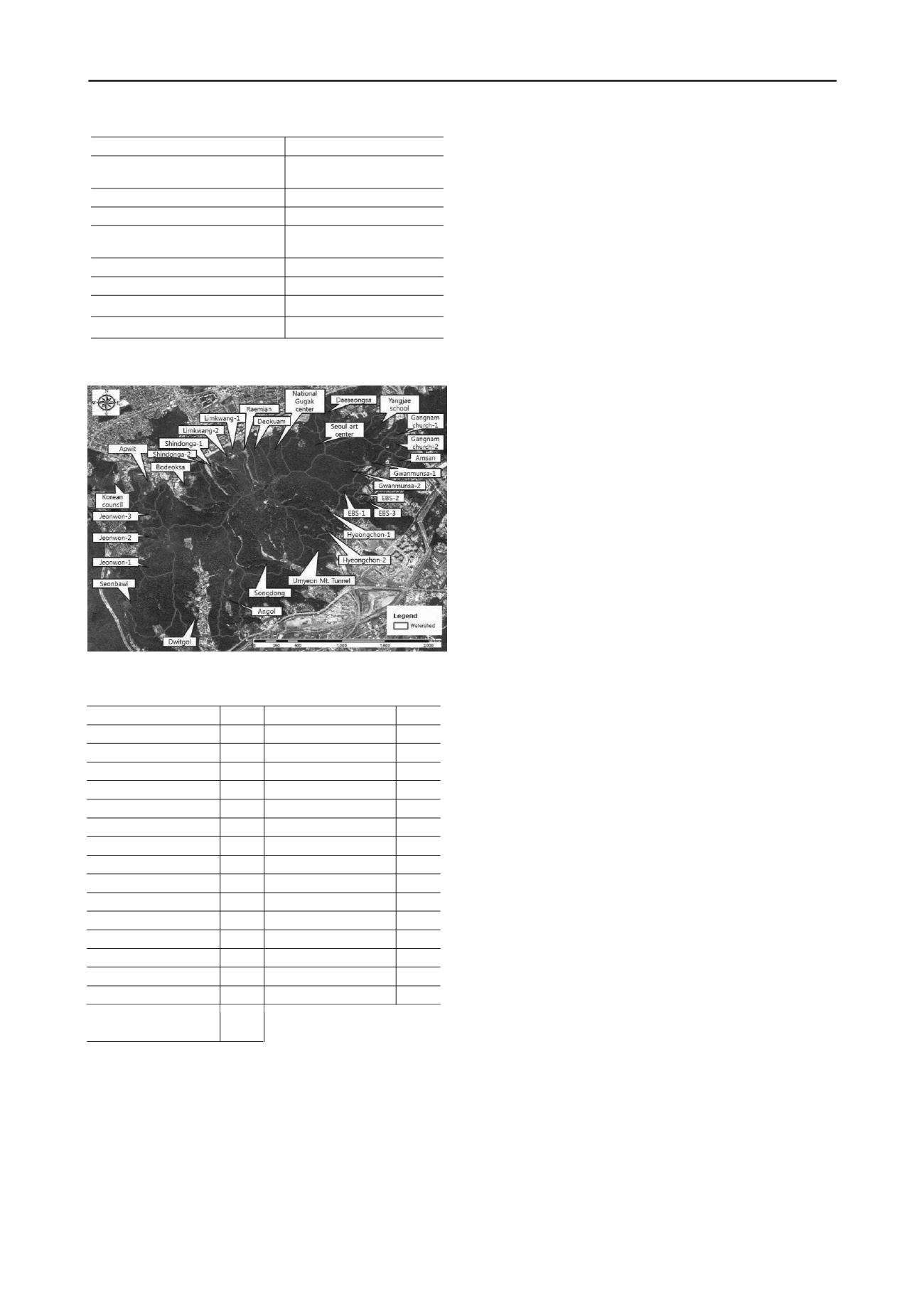
Figure 9. Watersheds in Umyeon Mountain
Johnson, A.M. and Rahn, P. 1970. Mobilization of debris flows, Z.
Geomorphology 9, 168-186.
Table 2. The probability of debris flow hazard for individual watershed
Lee, S.-W., Kim, G.-H., Yune, C.-Y., Ryu, H.-J., and Hong, S.-J. 2012.
Development of Landslide-Risk Prediction Model thorough
Database Construction, Journal of Korea Geotechnical Society
28(4) 23-33. (in Korean)
Watershed
Prob.
Watershed
Prob.
Raemian
84%
EBS-1
77%
Limkwang-1
72%
EBS-2
70%
Limkwang-2
76%
EBS-3
71%
Shindonga-1
87% Gwanmunsa-1
96%
Shindonga-2
87% Gwanmunsa-2
97%
Hyeongchon-1
99%
Amsan
73%
Hyeongchon-2
92% Gangnam church-1
71%
Jeonwon-1
94% Gangnam church-2
79%
Jeonwon-2
80% Yangjae school
84%
Jeonwon-3
75% Daeseongsa
79%
Bodeoksa
99% Seoul art center
96%
Apwit
69% National gugak center
87%
Korean Council
73%
Dwitgol
99%
Songdong
99%
Angol
90%
Umyeon Mt. tunnel
83%
Seonbawi
17%
Deokuam
85%
Son, S.-H., Choi, B. and Paik, J. 2012. Characteristics of rainfall and
groundwater table in a small forested watershed of Mt. Umyeon,
Proceedings of 38th Korea Society of Civil Engineering
Conference and Civil Expo 2012, Chonnam National University,
Korea, October 24-26
Yune, C.-Y. and Jun, K.J. 2011. National investigation on the landslides
and debris flows in 2011, Korea, River and Road in Mountain Area,
Vol. 4, Special publication, 15-19.


