2290
Proceedings of the 18
th
International Conference on Soil Mechanics and Geotechnical Engineering, Paris 2013
2010, regional intensive rainfall following Typhoon Kompasu
caused a few landslides, and some of them developed as debris
flows at the northern valleys in Umyeon Mountain (Fig. 2).
However, the damage in 2010 was not great compared with the
debris flow hazard in 2011.
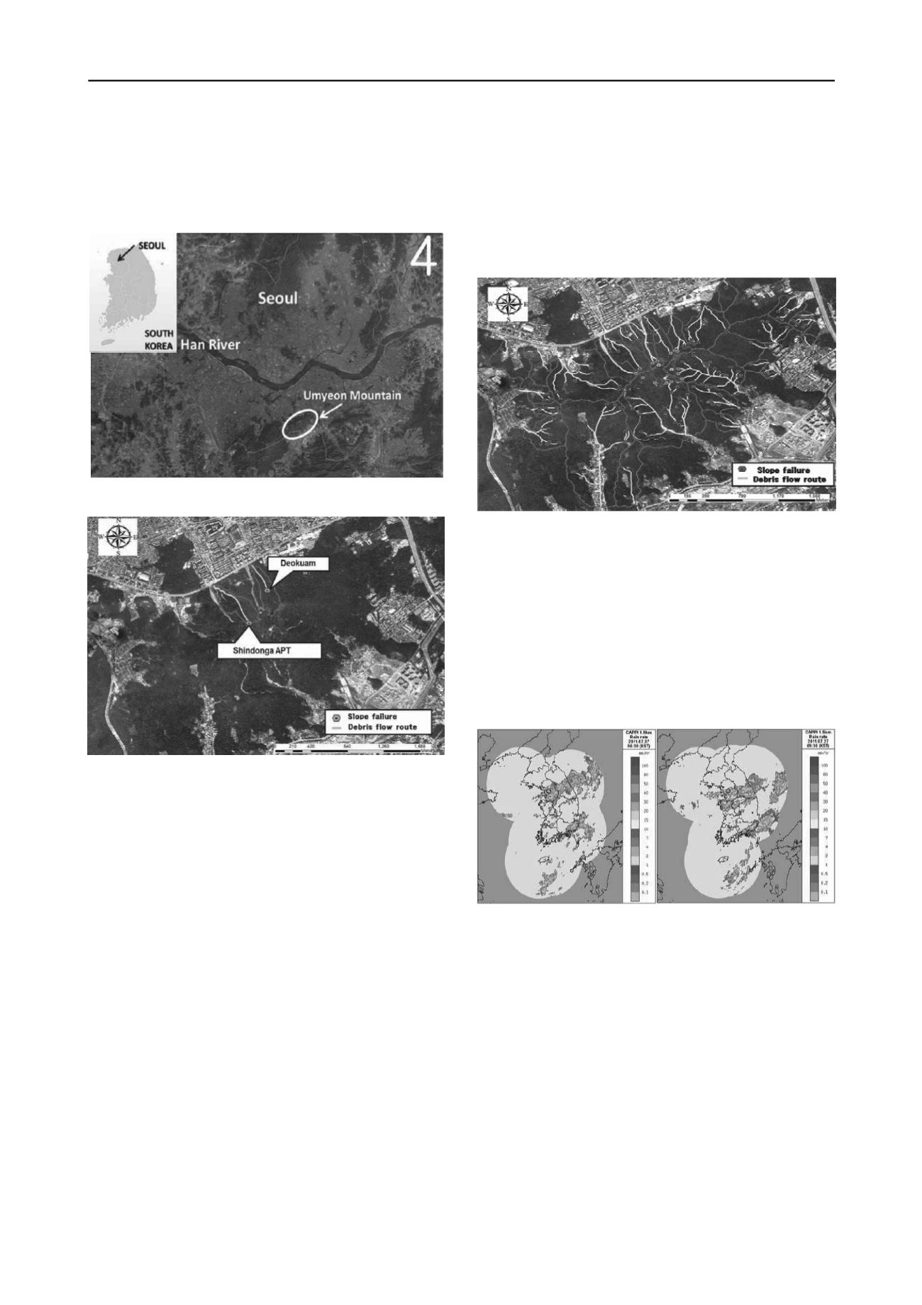
Figure 1. Location of Umyeon Mountain
Figure 2. Locations of Slope Failures and Debris Flows around Umyeon
Mountain in 2010
2.2.
Field Survey
Field survey was performed to get data, such as
longitude/latitude and topographical/geotechnical characteristics
in places where debris flows were initiated, transported, and
accumulated using a portable GPS, a laser ranger, and a
clinometer. Based on the data from field survey, coordinates
regarding initiation zones and debris flow routes were indicated
on an aerial photograph around Umyeon Mountain as shown in
Fig. 3. In this figure, the initiation slope failures are marked by
blue dots, and debris flow routes are marked by yellow lines.
Orange dots and green dots are also the initiation slope failure at
the boundary and inside of air force base at the summit of the
mountain, respectively. Most of the debris flows were initiated
by slope failure and flowed down the valley. It was determined
that they occurred simultaneously in the whole Umyeon
Mountain area. The total number of slope failure that initiated
debris flow was about 150. Based on the outlet in which the
debris flows accumulated, the number of debris flows was about
33.
When we classified debris flows by direction, it was found
that many of the slope failures occurred on the southern slope
but many of the debris flows occurred on the northern slope.
The debris flows moving towards the south were channelized
debris flows which flowed down the valley and merged
together. On the other hand, debris flows on the northern slope
were hillslope debris flows which moved rapidly without being
confined in an established channel. Therefore, the northern
slope has fewer initiation zones but more debris flows compared
to the southern slope.
The field survey result showed that the average moving
distance of debris flows in Umyeon Mountain was about 615m,
ranging from 95 to 1,584m. Also, the average gradient of
initiation slopes was about 27 degrees, ranging from 11 to 37
degrees. The initiation volume of the slope failure was
measured from 73 to 4,000 m
3
.
Figure 3. Locations of Slope Failures and Debris Flows around Umyeon
Mountain in 2011
2.3.
Rainfall Conditions
Korea Meteorological Administration (KMA) reported that the
torrential heavy rain which triggered landslides at Umyeon
Mountain in 2011 was due to unstable atmospheric conditions
mainly determined by cold and dry air from inland China along
with the hot and humid air masses from the strong Southwestern
wind alongside the Western North Pacific subtropical high (Fig.
4).
(a) 6:30 a.m. 27 July 2011 (b) 9:30 a.m. 27 July 2011
Figure 4. Spatial patterns of rainfall in Korea peninsula by KMA
There are two automatic weather stations (AWSs) operated
by KMA near Umyeon Mountain as shown in Fig. 5.
Namhyeon and Seocho stations are located at west and
northeast part of Umyeon Mountain, respectively. Rainfall
records from Namhyeon and Seocho stations were analyzed as
daily and cumulative rainfall for 2 months as shown in Fig. 6.
The cumulative rainfall for 2 months before debris flow event
was 1,489.5mm and 1,105.0 mm at Namhyeon and Seocho
station, respectively. Those values were comparable to the
average annual rainfall in Seoul (1,450.5 mm). A significant
amount of rainfall (681.5 mm at Seocho station) was
concentrated during the period from 21 June to 18 July which
was 10 to 36 days before the occurrence of the debris flows.
Then there was no rainfall up to 4 days before the debris flow
event and 88.5 mm of rainfall was recorded 1 to 3 days before
debris flow. On the day of the debris flows, 359 mm and 281
mm of rainfall at Namhyeon and Seocho station were recorded.
Unlike neighboringGwanak Mountain, which is primarily


