3184
Proceedings of the 18
th
International Conference on Soil Mechanics and Geotechnical Engineering, Paris 2013
Figure 1. Plan of area surrounding Grand Arcade.
The re-development at the site involved the demolition of a
number of existing buildings and because of the long history of
occupation in the area, archaeological investigation was
undertaken prior to the main construction works starting.
To form the basement substructure, zero sheet-pile and
secant bored pile perimeter retaining walls were installed where
needed, and ground levels were reduced generally by between
4 m and 7 m across the site.
The gross weight of the new structure was equivalent to a
uniform loading of about 120 kPa which with an average
unloading due to demolition and excavation of 80 kPa (ranging
between 30 and 100 kPa), equates to a net loading of 40 kPa.
However, this varied somewhat across the site and as a result in
some areas, e.g. under core structures and some columns, net
contact pressures locally were as high as 220 kPa.
During tendering, a value engineering exercise was
undertaken and the option of replacing the conforming fully
piled foundation with a piled raft was investigated, and this
preliminary assessment suggested that significant savings were
possible using this alternative.
2 SOIL CHARACTERISATION
2.1
Site specific investigation and testing
In order to develop the ground model for the proposed raft
foundation it was necessary to supplement the site investigation
and laboratory testing previously completed with further, high
quality sampling and testing. Therefore, three additional 30 m
deep boreholes were completed using rotary coring techniques
and sub-samples were taken from the cores for stress path
testing.
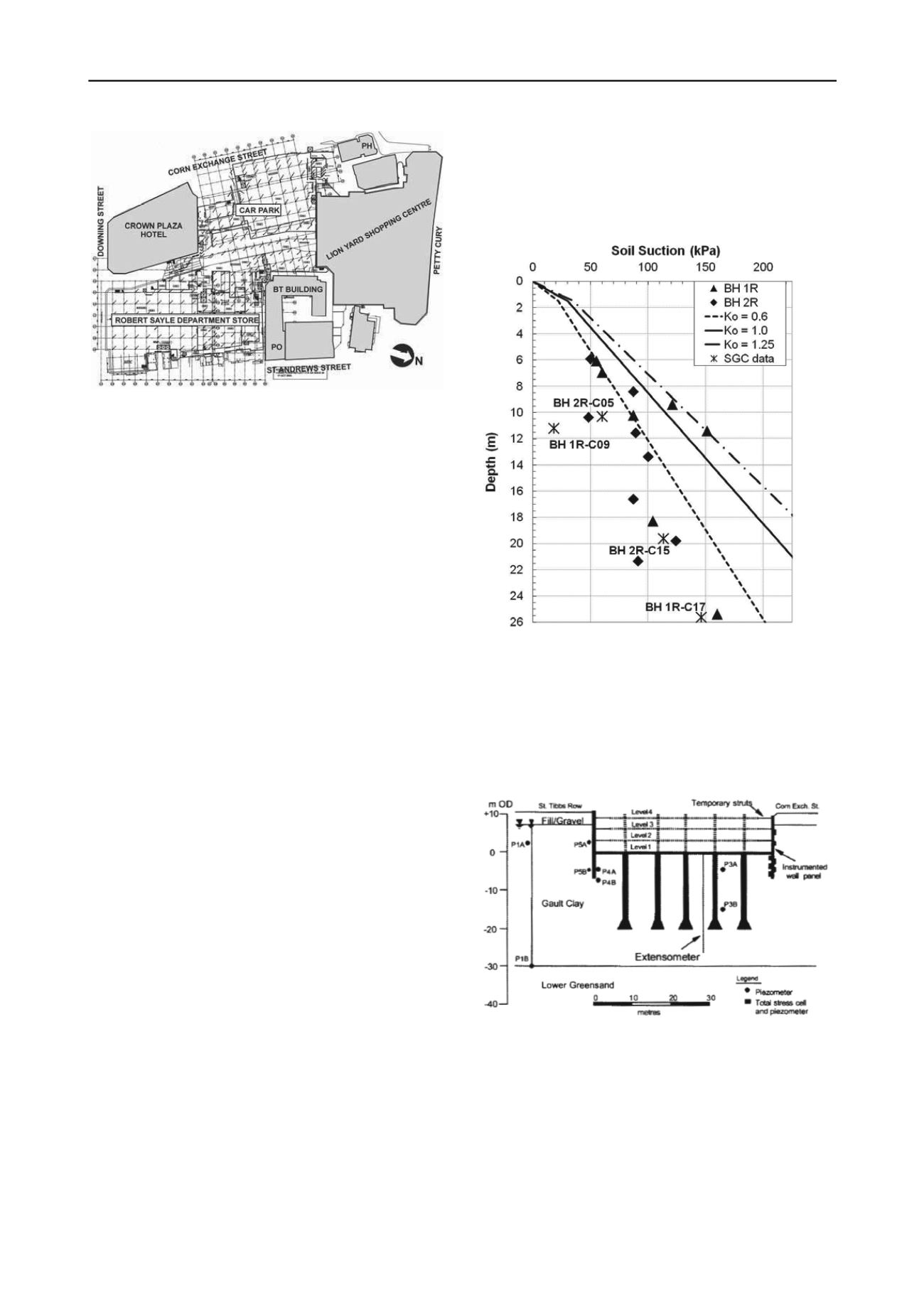
Prior to the stress path testing, the suction in each sample
was measured using the IC suction probe, in order to be able to
understand whether the samples may have been unduly
disturbed when recovered or when in transit.
These measurements proved to be very interesting (Fig. 2)
and while generally consistent they were significantly lower
than what would be expected based on experience in for
example the London Clay Formation, and imply much lower
values of “at-rest” earth pressure coefficient, K
0
than might be
expected based on a simple one-dimensional depositional and
erosion environment.
It is thought that the post-depositional processes alluded to
earlier and especially the lateral changes resulting from historic
tectonics may have led to lateral stress relief and generally
lower K
0
values in the Gault Clay. There is also the possibility
that the clay simply cannot maintain suctions high enough to
reliably represent the in situ stress conditions, although this is
considered less likely - similar results in terms of suction
measurement from large diameter (300 mm) samples of Gault
Clay recovered from a site near Cambridge were seen by the
Authors.
Stress path testing was undertaken on six samples to
examine the changes in soil stiffness, during stress paths
representative of the expected unloading during demolition and
excavation, and reloading as the raft is constructed and loaded.
Figure 2. Sample suction profile and implied K
0
values
2.2
Ground response at adjacent site
When developing the ground model for design of the piled raft,
it was recognised that next door there was effectively a full
scale element test available in the form of the instrumented 10
m deep basement excavation created for the Crown Plaza Hotel
(Fig. 3).
Figure 3. Basement layout and instrument locations, Nash et al (1996)
The instrumented basement construction provides very
useful information in terms of the vertical ground movements
associated with unloading during excavation and in the long-
term (Nash et al. 1996, Lings et al. 1991). And while
acknowledging that the piled foundations will have influenced
the observations to a degree, the data (Fig. 4) was able to be
used to make an independent assessment of the non-linear
stiffness of the soil mass with depth and strain level. In
particular the excavation to Level 2 was of interest as this
represented the level of excavation in the new development.


