3146
Proceedings of the 18
th
International Conference on Soil Mechanics and Geotechnical Engineering, Paris 2013
the Northern Hemisphere, which was the last record of
Pleistocene glacial advance (Bentley 2005, McCulloch, 2005a).
The glacial processes deposited different sediments in the form
of terminal, basal and lateral moraines, whereas glacial
meltwater during the interglacial periods generated outwash
plains. During warmer intervals peat bogs proliferated.
There is evidence that a large pro-glacial lake formed in the
present Magellan Strait. Dating of a volcanic ash layer from the
Reclus Volcano indicates that this happened before 12,640 ± 60
14
C yr BP (McCulloch
et al
. 2005b). The low level of the
Atlantic Ocean and the glacial barriers between the fjords,
which did not allow the influx of waters from the Pacific Ocean,
favored the deposition of varved clay and glacio-lacustrine clays
in a freshwater environment, thus preventing the development
of quick clays.
3 SOIL CHARACTERISTICS
3.1 General
The term “mazacote” is locally used to refer to a group of soft,
bluish grey soils, considered in engineering as having poor
geotechnical properties. Nevertheless, recognizing the
complexity of depositional environments, events and structures
that were superimposed during different geological periods, it is
of prime importance to differentiate between push, basal and
flood tills, outwash plains, lacustrine varved clays, organic
clays, peat, and fine as well as coarse fluvial sediments with
different compaction properties.
Till or moraine, a product of glacial erosion and plucking, is
one of the most heterogeneous sediments because of its poor
sorting. Its composition and structure depend on the manner in
which it has been transported and the diagenetic history, so that
it may vary from a dense till with a non-plastic matrix to a clay-
rich till with a low consistency. Its sedimentary provenance is
difficult to determine due to the fact that the material was
transported from different, proximal or distal source areas, and
subsequently suffered reworking. Geotechnically, it is important
to differentiate between strongly pre-consolidated basal tills and
melt-out till that is generally similar to normally consolidated
clays.
The large pro-glacial lake and the presence of co-existing
smaller lakes along the shores of the Magellan Strait provided
the conditions for the deposition of lacustrine sediments, among
which one of the most important types is varved clays.
The fine sediments associated with fluvial overbank areas
with lower flow-regime currents, were deposited during modern
inundation events, and geotechnically behave like normally
consolidated clays (Vásquez 2012). These materials may show
specific properties such as interbedded clay and silt,
sedimentary structures including troughs and ripples (see figure
1), a high organic content (transported by water or formed
in
situ
by local vegetation), laminas of coarse or fine sand with
gravel lenses, the presence of sporadic gravel clasts with a
maximum size of 1 cm, mica, carbon spheres, and strong
oxidation.
Figure 1. Overbank fluvial sediments.
The glacial landscape, formed by rolling hills with abundant
depressions, intermoraine channels and kettles, together with
the Quaternary climatic changes, provided the necessary
conditions for the evolution of peat bogs. Due to the fact that
the area around the Strait was subjected to various glacial
retreats, it is common to find significantly thick, vertically
repeated peat bog deposits (see figure 4).
3.2 Structures
The soils derived from glacial environments show structures
such as cracks, fractures, and complex deformation that depend
on the material, the flow regime, the types of forces to which
they had been subjected, as well as the water content. Sandy
sediments deposited by slow currents may show undulating,
continuous laminas, whereas soft sediments such as silty clay, if
they have a high humidity content, develop structures like load
casts, soft-sediment and recumbent folds, chaotic bedding, fluid
escape structures, and polygonal mud cracks,
inter alia
. During
field work it was common to observe slickensides, smooth
oxidized surfaces caused by foliation slip in the tills, which
indicate the intermittent laminar flow of fluids along
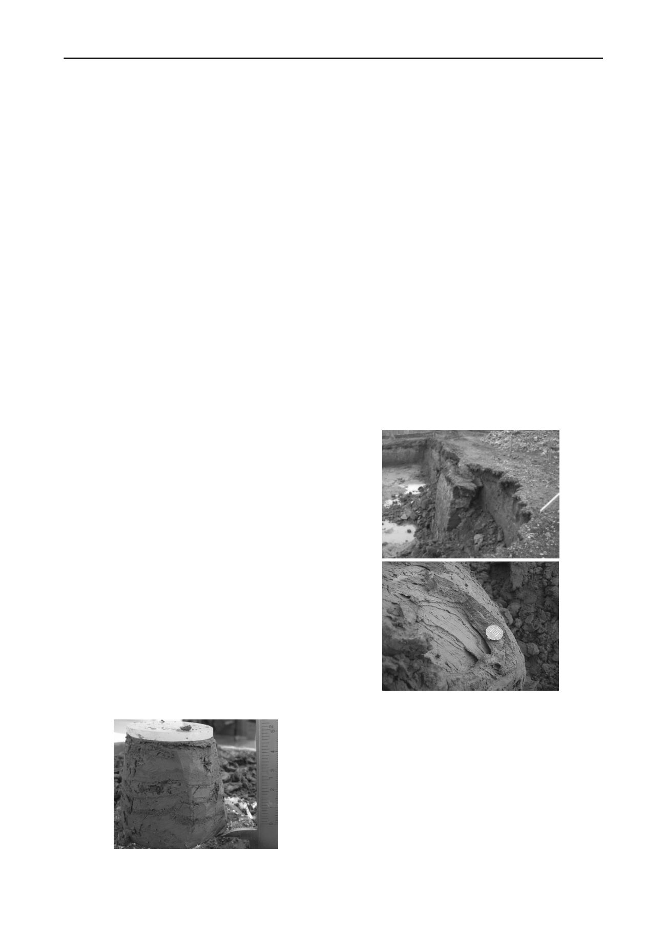
discontinuities. At a macro-scale, the collapse of sub-vertical
blocks in excavations could also be observed (see figure 2A).
This can be explained by the vertical loading caused by the
overlying glaciers and the subsequent lateral pressure-release
within the excavations.
Another specific characteristic of the study area is the
significant sub-glacial deformation of the sediments due to the
shear force exerted by the overriding glaciers (see figure 2B). In
road cuts, moraines show complex folds, faults and foliations
with orientations indicating the direction of glacial advance.
A
B
Figure 2. Structures in glacial sediments, Punta Arenas. A) Collapse of
sub-vertical blocks in excavations. B) Foliations in sub-glacial till.
3.3 Geotechnical characterization
Undisturbed soil samples were collected within the urban and
sub-urban perimeter of the city, which were tested in the
Laboratory of Solids and Particulate Matter of the Faculty of
Physical and Mathematical Sciences of the University of Chile.
Descriptions of the samples indicate specific components and
structures such as the presence of carbon particles, plant roots,
sedimentary structures such as ripples, micro-lamination, varved
clay, laminas of coarse and fine sand with gravel lenses, the
presence of gravel (which complicated the cutting of test cores),
mica, and rapid oxidation in contact with the atmosphere.
The variety shown by the soils in terms of plasticity, (see
figure 3) is surprising, which demonstrates that the glaciation
left its mark in the extreme differentiation of the deposits. This


