3148
Proceedings of the 18
th
International Conference on Soil Mechanics and Geotechnical Engineering, Paris 2013
Zones
Station
Isoline composite map
Flow direction
Tierra del
Fuego
B C
B
Península
C
Juan Mazía
D
B
Estrecho de Magallanes
Punta Arenas
6 ACKNOWLEDGEMENTS
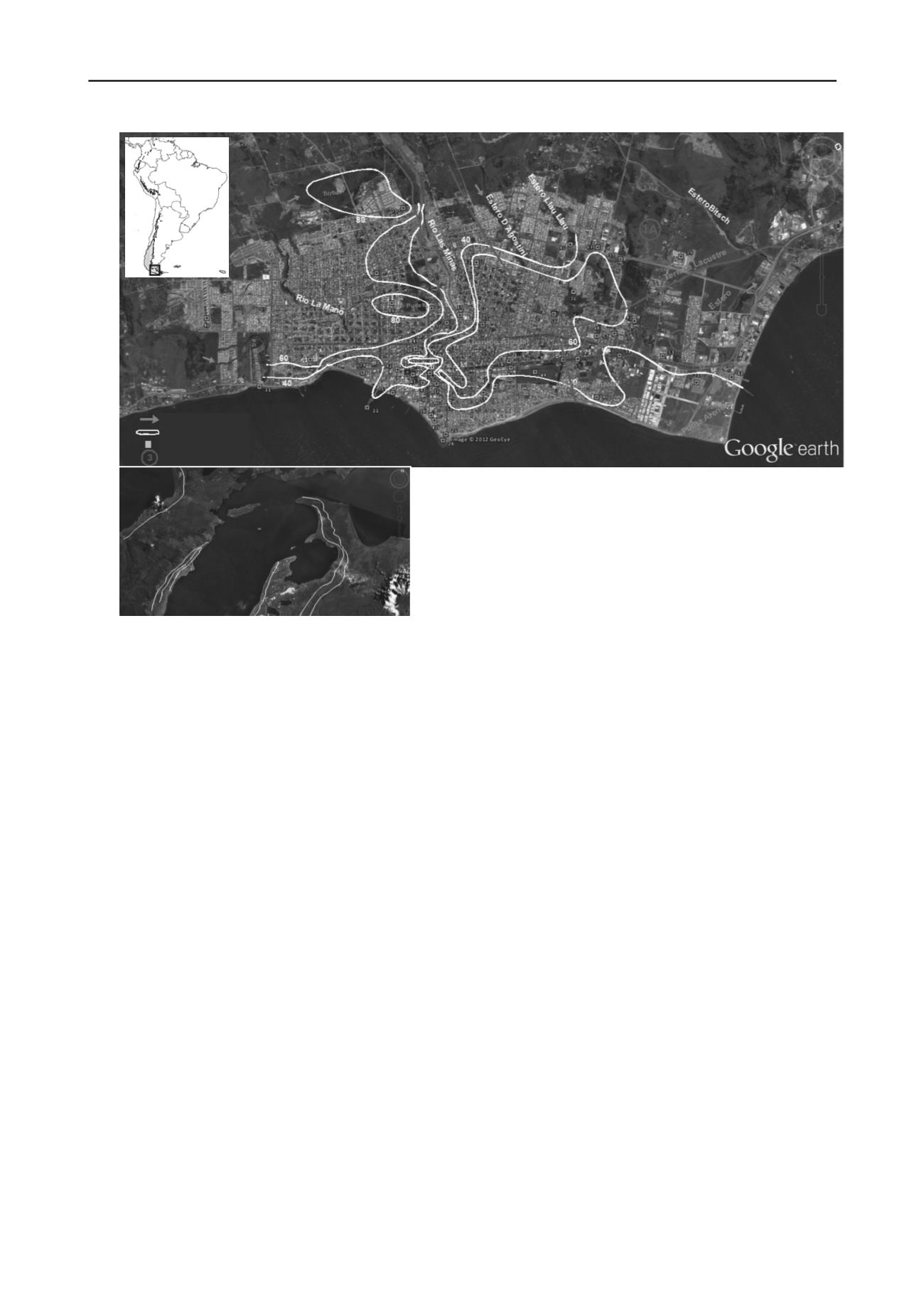
Figure 5. Location map of the study area. Composite map of Punta
Arenas. Google Earth view of the city and Magellan Strait with stages
of deglaciation labelled B-D, where B is the oldest and D the youngest
moraine (after Bentley
et al
. 2005).
This study was possible thanks to the support of Professor
Ramón Verdugo, Coordinator of the Master Program in
Geotechnical Engineering at the University of Chile, Gonzalo
Espinoza, Regional Director of DOH (Hydraulic Works Office),
XII Region, Magallanes and Chilean Antarctica, Héctor
Szigethi for the valuable information on boreholes drilled under
his supervision, and to the deceased geotechnical engineer Issa
Kort for his important support in the field.
5 REFERENCES
Using a spreadsheet and normalizing the data of topographic
elevation, type of sediment (employing a scale of 1 to 7 for the
coarsest to finest sediments, respectively) and the mean number
of blows (N-SPT) for every station, the resultant composite
value varies between 1 y 100 for the 57 stations. Finally, the
composite values were contoured and interpreted (see figure 5).
Bentley M.J., Sugden D.E., Hulton M.R.J., and Mcculloch R.D. 2005.
The landforms and pattern of deglaciation in the Strait of Magellan,
Bahía Inútil, southernmost South America. Geogr. Ann., 87 A (2):
313–333.
The composite map technique highlights the sub-basins
scoured by glacial action, in which soils of low bearing capacity
(soft clays and peat) coincide with isolines having values higher
than 60 and clearly demarcated by isolines having values above
80 (see figure 5). Additionally, the phreatic water levels in these
areas are close to the surface, which is one of the most
unfavorable conditions for foundation design.
Clapperton, ch., Sugden D.E, Kaufman D., and Mcculloch R.D. 1995.
The last glaciation in central Magellan Strait, southernmost Chile.
Quaternary Research, 44:133-148.
Le Roux, J.P. 1997. Palaeogeographic reconstruction using composite
maps, with case studies from three continents. Palageography,
Palaeoclimatology, Palaeocology, 131: 51 – 63.
Mcculloch, R.D., Fogwill, C.J., Sugden, D.E., Bentley, M.J. and Kubik,
P.W., 2005a. Chronology of the last glaciation in the central Strait
of Magellan and Bahía Inútil, southernmost South America.
Geografiska Annaler, 87 A (2): 289–312.
Mcculloch, R.D., Bentley, M.J. Tipping, R.M. and Clapperton, C.M.
2005b. Evidence for late-glacial ice-dammed lakes in the central
Strait of Magellan and Bahía Inútil, southernmost South America.
Geografiska Annaler, 87 A (2): 335–362.
4 CONCLUSIONS
Soils in the city of Punta Arenas show an extraordinary
variation in their index and engineering properties, which makes
them difficult to assess for sound geotechnical designs.
Szigethi, H.; 1995-2010. Informes de laboratorio de mecánica de suelos
y comunicaciones personales, Punta Arenas.
The combined, non-dimensional parameters of the composite
map reveal the complex geological processes these areas have
experienced. A study of the geological events during the Last
Glacial Maximum allows the characteristics of the soils to be
explained in terms of composition as well as in their effect on
existing structures.
Uribe P.; 1982. Geología y consideraciones geotécnicas para el estudio
de los suelos de fundación de la ciudad de Punta Arenas. Informe
taller de título II. Departamento de Geología Universidad de Chile.
Vásquez, A.; 2012. Suelos de fundación de la ciudad de Punta Arenas.
Tesis magíster en ciencias, mención ingeniería geotécnica.
Santiago, Universidad de Chile. 136 p.
The composite map allows the definition of a tentative
zonation which shows areas with more compressible soils and
low shear strength associated with depressions containing
lacustrine sediments such as clay and peat.


