2918
Proceedings of the 18
th
International Conference on Soil Mechanics and Geotechnical Engineering, Paris 2013
maximum height of 5.2m. The values of the end of primary
settlement (
ρ
f
) and c
v
/
H
2
d
were determined from instrumental
data for the two loading stages. The authors interpreted
measurement to find equivalent
c
v
values, after roughly 5
months when at least 95% of the primary settlement was
reached. In the third experimental fill, with a maximum hight of
6.7, they also inferred c
v
values from instrumental observations.
A third experimental fill (Pilot Embankment 3), built also in
Area 3, with a maximum height of 6.7m, behaved in a similar
way, with c
v
/
H
2
d
averaging 1.8.10
-2
/day; the
EOP
settlement
was ~80 cm and 95% of this value was reached after ~6 month.
Due to the relatively high
OCR
values of the SFL Clays, the
c
v
were also high, of the order or 10
-2
cm
2
/s. As a consequence,
there was no need to use geodrains in the Embraport site.
This conclusion was supported by instrumental observations
in three experimental earth fills without geodrains and, more
important, by the monitoring of settlements in the area where
temporary surcharges were used. These results show that
controversies that after arise about the use of geodrains can be
overcome with proper characterization of soils present in the
field and from thorough and careful interpretation of
instrumental observations from properly instrumented trial fills.
The paper by Ooi
et al.
(2013) discusses the development of
geogrid applications in soft ground in Malaysia starting in 1984
when a road pavement field trial was first carried out. Other
experiences followed in the following years and in this paper
they report another project in which geogrids with geocells were
used. They compare the performance of three cases in which
geogrids were used, a fabrication yard, a heavy duty working
platform and a container yard working platform. They compare
and assess the pavements used in them and the magnitude of
settlement they underwent under construction and later
operations. All the three platforms were built over soft clays 4.5
to 10m thick and applied stresses due to heavy equipment was
as high as 500kPa and axial loads of heavy vehicles reached
105tonnes. Granular fill of varying thicknesses were used in all
three working platforms. The authors state that mechanically
stabilized soils using biaxial and triaxial geogrids with granular
fill with or without geocell mattress performed satisfactorily in
terms of platform settlement performances to support the
heavily loaded platforms.
The case history presented by Asiri and Masakasu (2013)
deals with the design and performance of a highway
embankment constructed in Sri Lanka over very soft soils and
alluvial clays. The project required that settlements be limited to
less that 15cm after three years and those residual differential
settlements be less than 0.3%. Soils were improved by means
of wick drains, heavy tamping, pre loading with surcharges and
vacuum consolidation. The soil improvement method was
adjusted depending local geotechnical conditions. The major
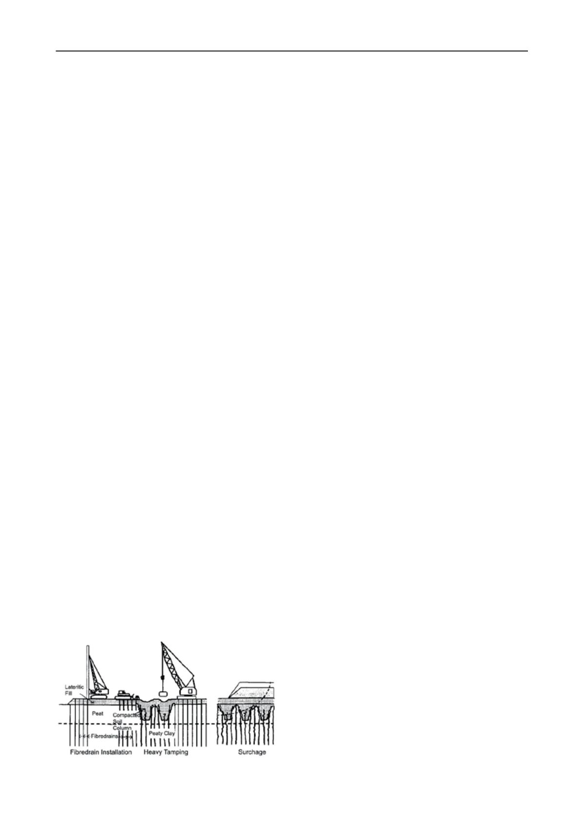
steps in ground improvement method and illustrated in Fig 3
are: a) placing surcharge loads with or without drains for soft
clays of shallow thickness; b) removal of peaty soil, replacing it
rock fragments; c) applying heavy tamping or, alternatively,
vacuum consolidation for deeper strata. Heavy tamping was
only effective down to 3.5 to 4.0m
Figure 3. Major steps in heavy tamping ground improvement method
(Asiri and Masakasu , 2013)
Vacuum consolidation was applied using band drains with a
spacing of 1m. Primary consolidation settlements were
compensated and secondary consolidation deformation
minimized by applying a vacuum pressure of 70kPa. There were
places where it was not possible to apply vacuum and in those
cases, soil improvement was carried out by applying surcharge.
The continuous assessment of the improvement of soft
ground was carried with field instruments: settlement plates,
pyrometers, a vacuum pressure monitoring unit and a water
discharge meter. The decision to remove the surcharge was
made on the basis of the monitoring data obtained during the
surcharge period. The aim was to eliminate 100% of the
primary consolidations settlement and enough secondary
settlement.
De Silva and Fong (2013) describe and discuss the case of
the Cotai Landfill, the main receiving facility in Macau for
building construction waste. As the dumping site is underlain
with a thick layer of very soft to soft marine clay deposits, the
uncontrolled end-tipped material has generated mud waves and
they were encroaching the piles supporting the Macau
International Airport taxiway nearby. In order to prevent future
potential damage to the taxiway, the Macau Government
commissioned the design of a containment bund adjacent to the
taxiway to retain the waste and to prevent further generation of
mud waves that would affect the taxiway.
This paper presents the design approach of the containment
bund including the results of a limit equilibrium stability
analysis and the numerical analyses carried out that
demonstrated that the solution is appropriate as the bund will
contain the landfill with minimal impact on the taxiway bridge
piles. The analyses also demonstrated that the impacts during
construction are also negligible. The sustainable design
comprised the installation of vibrocompacted stone columns
installed in over 20m thick, very soft to firm, moderately
sensitive marine clay and alluvial clay, as the foundation to the
waste retention bund, thereby avoiding the dredging and off-site
disposal of a significant volume of dredged sediments. This
paper presents the design approach and construction of the stone
columns and the behaviour of the completed seawall.
The authors show instrumental observations to monitor
during the taxiway and seawall during construction. Survey
results indicated that the installation of the stone columns and
construction of the bund had minimal impact on the taxiways
foundation piles. The seawall was been completed in November
2011.
6
SOIL FRACTURING
Auvinet and Mendez (2013) present updated information
concerning land subsidence and associated soil fracturing in
Mexico City. Subsidence was estimated from the evolution of
the elevations of 2064 benchmarks and other references located
in former Texcoco Lake. Geodesic and topographic surveys
carried out in the middle of the XIX
th
century proved to
constitute an excellent initial reference for subsequent
measurements of land subsidence. Extensive use was made of
new geocomputing tools to process these data. Results of
surveys of soil fracturing associated to subsidence are also
presented and discussed
The demographic development in Mexico City has created
an accelerated demand of services, mostly of potable water. One
of the cheapest ways to meet this demand has been the
exploitation of the local aquifer by pumping water from deep
wells. This has produced a water pressure drawdown in the
subsoil that in turn is causing general subsidence of the former
lacustrine area and soil fracturing. This problem has been
around for almost a century but is now reaching new worrying
dimensions. Although regional land subsidence is an old
phenomenon, it has not been possible to control it. In fact, it is
expected to continue in the future for many more years since,
due to the high cost of other alternatives, water pumping from


