2270
Proceedings of the 18
th
International Conference on Soil Mechanics and Geotechnical Engineering, Paris 2013
A landslide risk analysis thus includes three separate parts:
-
the estimation of the probability for a landslide to occur,
-
the determination of the consequences of such a landslide,
-
the combination of these two factors resulting in a risk
map.
Landslide probability is based on the calculation of the
safety factor using conventional stability analysis. By studying
the uncertainties in a number of parameters used in the
calculation of the safety factor in a given area, the probability of
a failure occurring in this area is estimated. The probability is
therefore directly dependent on the safety factor and the
variation in different parameters such as slope geometry, shear
strength and density of the soil, etc. The probability of landslide
occurrence is divided into five probability classes from
"negligible probability of landslide" (probability class S1) to
"substantial probability of landslide" (probability class S5).
The impact of a landslide in an area, i.e. damage to life,
property and environment, is also defined in five consequence
classes, from "minor damages" (consequence class K1) to
"catastrophic damages" (consequence class K5). The
assessment of the consequences of a landslide takes into
account the damage that a possible landslide would cause.
Extent of the damage is assumed to be in proportion to how the
land is used for dwelling, industries, infrastructure and other
facilities and activities. Of course, the size of the landslide is
important for the assessment of the consequences, both on land
and in the river, and it is affected by the presence of quick clay
in the area as well as the topography of the slope. In earlier
investigations, the consequences were described following a
scale with incremental effects, but in the present project the
financial aspects have been added on the impact assessment in
order to more systematically compare the consequences of
landslides in different areas, affecting different functions in the
society.
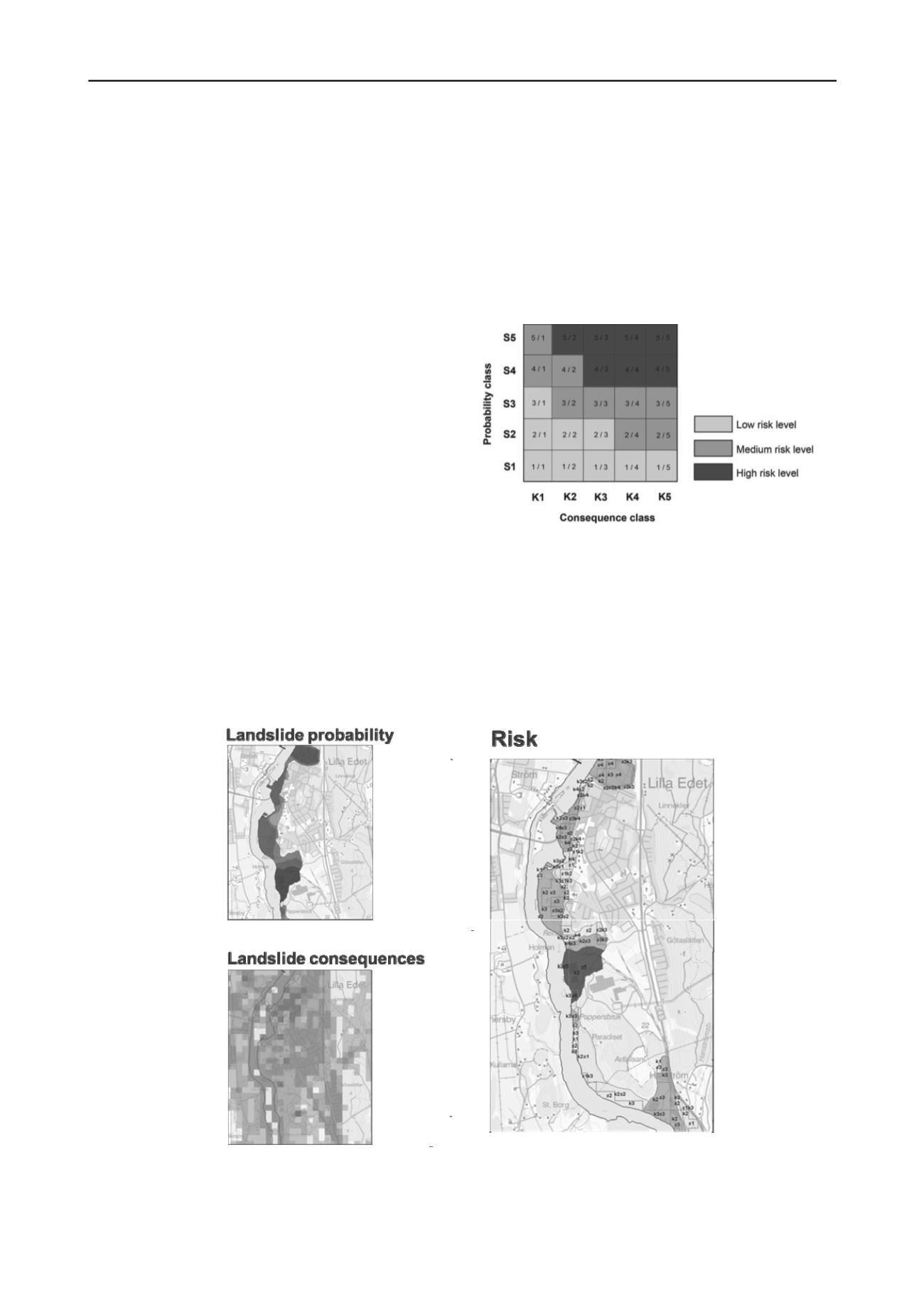
The combination of landslide probability classes and
landslide consequence classes results in an expression of the
risk of landslide. Landslide risk class is expressed as a pair of
numbers that reflects the consequences of a landslide (K) and its
probability to happen (S). A total of 25 risk classes may be
obtained from the risk matrix, see Figure 2, and they are
clustered into three risk levels (low, medium, high) in order to
simplify the risk mapping. The different levels of risk of
landslides involve different requirements for geotechnical
actions including the need of detailed stability investigations
and eventually protective measures.
Figure 2. Risk matrix used in the present investigation.
The landslide risk map is obtained by overlaying the
probability map and the consequence map and combining them
into risk levels. The results of the risk analysis is finally
presented in colored maps representing the three risk levels
(low, medium and high) as shown in Figure 3. Areas with no
landslide risk, e.g. areas with visible bedrock, are omitted from
the risk map.
Figure 3. Principle of landslide risk mapping: probability map and consequence map are combined into a risk map.


