2278
Proceedings of the 18
th
International Conference on Soil Mechanics and Geotechnical Engineering, Paris 2013
microcomputer with independent power supply by batteries or
solar cells. Radio modems operated in the 429 MHz ISM band
for Japan, 434 MHz ISM band for E.U. counties and China.
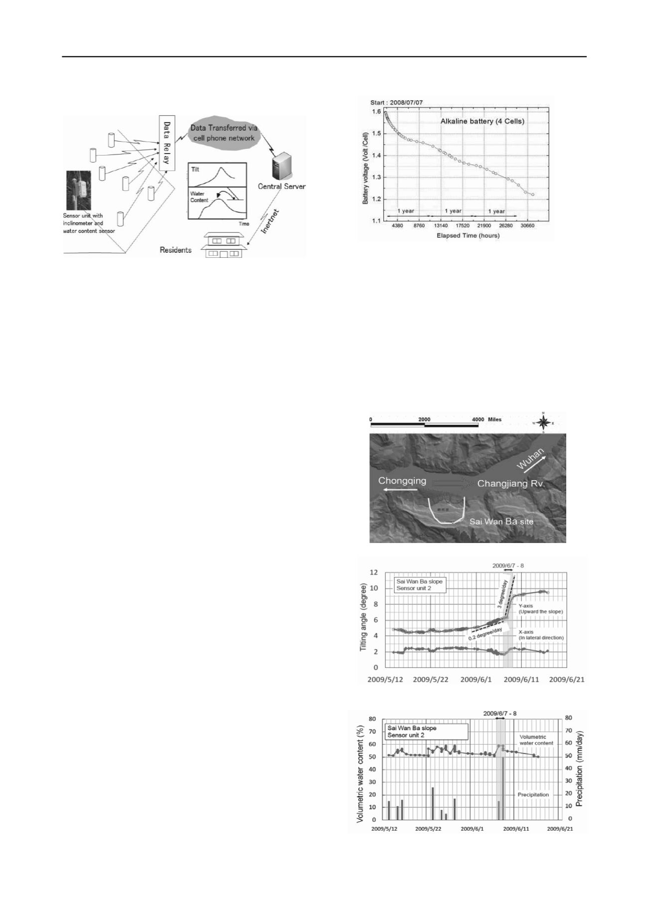
The sensor units measure the condition of the slope
periodically every 10 minutes for example. The data is
transferred to a gateway unit, which is also placed near the
slope, by using low power radio communication modules. The
data transmitting distance is 300-600 meters under typical
conditions in the field. The gateway unit collects the data from
all the sensor units, and sends them to a data server on internet
through a mobile phone network. Thus, the data can be browsed
anywhere and anytime on web site. The data is processed by the
server, and any abnormal phenomena of the slope can be
detected and used for a precaution of failure, and then issue an
evacuation warning.
2.2 MEMS inclinometer technology embedded to sensor unit
The proposed system measures the inclination on the slope
surface and the volumetric water content in the slope. A MEMS
tilt module (nominal resolution = 0.04 mm/m = 0.0025 degree)
is embedded in each sensor unit. The tilt module is a 3D-
MEMS-based dual axis inclinometer that provides sensor unit
grade performance for leveling applications. The measuring
axes of the sensing elements are parallel to the mounting plane
and orthogonal to each other. Low temperature dependency,
high resolution, power-saving and low noise, together a with
robust sensing element design, if we keep on leveling
installation, this MEMS type inclinometer is ideal choice for
slope failure sensors.
2.3 Saving power designed based on 16-bit ultra-low-power
MCU
In order to reach the purpose of a low-cost and simple warning
system, the choice of CPU controller become very important.
16-bit Ultra-Low-Power MCU with ultralow power
consumption being very suitable to no commercial power
supply region was selected.
A long-term sensor unit power consumption test (not include
Micro SD) was started on July 7, 2008, the interval time of data
sampling and transmit was 10 minutes. 4 cells alkaline batteries
were installed in the test senor unit. Figure 3 shows the relation
of battery voltage and elapsed time, the test unit has been
worked for 3.5 years.
3 FIELD VALIDATION FOR SIMPLE SLOPE
MONITORING AND LANDSLIDE IN JAPAN AND CHINA.
3.1 A case of detection on Three Gorge Dam landslide failure
in China
Prototype of the developed monitoring system has been
established on a side slope of Three Gorge Dam region, the
world largest dam in China, since 2008. The site named Sai-
Wan-Ba is located on the right side of the dam lake, near
Wenzhou Ward, 80 km eastward from Chongqing City (Figure
4). Several landslide blocks were found by geological
investigations.
The time histories of the tilting angles in X-axis and Y-axis,
the volumetric water content at a depth of 30 cm on the ground
surface, and the record of precipitation are shown in Figure 5
and Figure 6 respectively.
A consecutive movement of a sliding block shown in Figure
5 was observed for a long period. A quick movement of tilt
sensor was detected at a heavy rainfall event on June 6-7. 2009;
a large scale of landslide disaster nearby observation point 2
Figure 2.Outline of wireless monitoring units and early warning
system for slope failure.
Figure 3. Sensor unit long-term power consumption test.
Figure 4. Location of Sai Wan Ba landslide site.
Figure 5. Time history of tilting angle & precipitation by sensor unit 2.
Figure 6. Time history of volumetric water content & precipitation by
sensor unit 2.


