2271
Technical Committee 208 /
Comité technique 208
3 EFFECTS OF CLIMATE CHANGE
Climate change is generally expected to result in increased
frequency of natural disasters. In order to limit the damages and
meet the new threat that a changing climate will mean for
society, it is necessary to work both proactively to identify risks
and to protect exposed areas by improving the quality of
planning with regard to the new situation. SGI has for several
years and on several occasions drawn attention to the
geotechnical impacts of climate change. The analysis was
summarized in an action plan for climate adaptation work and
reported in various publications including the report
"Geotechnical conditions for an increased flow of lake Vänern
to the Göta River", SGI Varia 565 (Hultén et al, 2006).
Expected climate change in the Göta river valley over the
coming 100 years includes gradually increase of yearly mean
temperature and precipitation, see Figure 4 and 5, resulting in a
higher mean water level in the river. The climate change will
also result in an increase in most intensive rainfall events, an
increased number of high and low discharges from the Lake
Vänern due to increased inflow during autumn/winter and
decreased inflow during spring/summer, and finally increased
100-year flows in Göta river tributaries (Bergström et al., 2011).
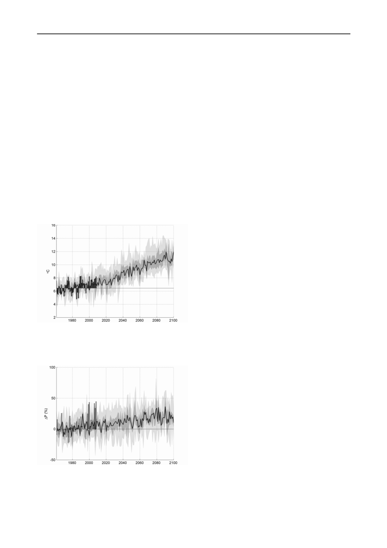
Figure 4. Calculated increase in temperature in the Göta river valley,
based on 16 climate scenarios. The historical observations are shown as
bars. The dark shaded area shows the 25-75 percentiles and the light
shaded area the maximum and minimum values. The black line is the
median value (after Bergström et al, 2011).
Figure 5. Calculated increase in precipitation in the Göta river valley,
based on 16 climate scenarios. The historical observations are shown as
bars. The dark shaded area shows the 25-75 percentiles and the light
shaded area the maximum and minimum values. The black line is the
median value (after Bergström et al, 2011).
A closer study of the results from the different climate
scenarios which were performed in the present investigation
shows a significant increase in precipitation during the
autumn/winter period, which means that the amount of water
coming to the Göta river through discharge from the lake
Vänern will increase, increasing the risk of erosion and the risk
of landslides along the river.
The forecast produced by the different climate scenarios
also shows reduced quantities of water during the drier
spring/summer periods in the Vänern basin. This means that a
lower water level is expected in the Göta river during these
periods and thus an increased risk of landslides due to the
decreased stabilizing effect of the water in the river. However,
t
he water level in the Göta river is controlled by the presence of
electric power plants along the river and is regulated by court
statements and different agreements between the electricity
producers and the authorities. Therefore, only minor changes of
the highest or lowest water levels are expected to occur due to
climate change. However, the mean water flow will increase
over longer period, causing erosion along the river.
Studies of the changes in groundwater levels have shown
that the expected variations are about 0,5 m in the area which
means a minor effect on the total stability (see Blied and
Persson, 2011).
An extensive study of the impact on the erosion process has
also been conducted in this project. The results show that a
number of river sections will be affected by the increase of flow
in the valley resulting in an increase of erosion (see Rydell et
al., 2011).
4 WORK DONE IN CURRENT INVESTIGATION
4.1
Stability conditions
To improve the basis for stability calculations, a detailed
topographical model of the area has been set up. The model
includes topography from a laser scanning on land and a
multibeam scanning of the topography of the river bottom.
Existing studies, surveys, maps, charts and other relevant
material were collected from various stakeholders and analyzed.
Inventory was also made regarding the older material from a
stability study in 1962, and other SGI investigations.
To get an overview of ongoing work and a reasonable
amount of stability studies, the river valley has been divided
into 10 different areas. For all of these areas, a number of
sections were chosen and studied using traditional methods to
estimate the stability conditions in the current situation.
Thereafter, the impact of climate change on the stability was
assessed and quantified. A total of 240 sections along the river
have been studied including over 2500 field investigation tests
and laboratory testing on about 4000 soil samples.
Erosion of the Göta River is a very important factor
associated with increased risk of landslides. Cooperation with
universities, government agencies and other appropriate bodies
was established early in the project in order to plan the study
and investigation work necessary for the implementation of the
mandate.
Mapping of quick clay areas has also been a major topic
studied in this project since it is a primordial parameter needed
for a better prediction of the size of expected landslides.
Improved investigation methods have been tested and
implemented in the project.
4.2
Consequences of landslides
In order to perform a complete risk analysis, elements that may
be affected by a possible landslide have been analyzed and
taken into account. Among the major elements included in the
study are human life, residential properties and infrastructures
as well as contaminated soils. Extensive work has been
performed for inventory, compilation and report of the selected


