3042
Proceedings of the 18
th
International Conference on Soil Mechanics and Geotechnical Engineering, Paris 2013
2 GEOLOGY AND HYDROGEOLOGY
Geology
Kooragang Island is located on the lower reaches of the Hunter
River and is about 10 km long by 3 km wide. The island was
formed by the reclamation of a number of former islands,
channels and mudflats using dredged sandy materials from the
river. The geology at the site comprises Permian aged Tomago
Coal Measures overlain by Quaternary alluvium. The Tomago
Coal Measures consist of shale, siltstone, sandstone,
conglomerate and coal. The depth to rock ranges from 30 m to
more than 70 m.
The overlying alluvium comprises fine to medium grained
estuarine sediments with some gravel zones, overlain by fluvial
sands with further fine grained estuarine deposits at the top of
the natural profile including soft silty clays up to 14 m thick.
The natural profile is overlain by significant fill materials
resulting from the former disposal of waste from steel making
and dredging activities. The fill is up to 12 m in thickness and
comprises a wide range of materials, including coal washery
reject, slag, coal fines, oil/tarry sludge, clayey silt filter cake,
kiln wastes, cell scale (gypsum and manganese dioxide),
asbestos, steel-making flue dust, lime sludge, timber dunnage
and various sporadic inclusions. The consistency of the fill
ranges from very soft to very dense/cemented.
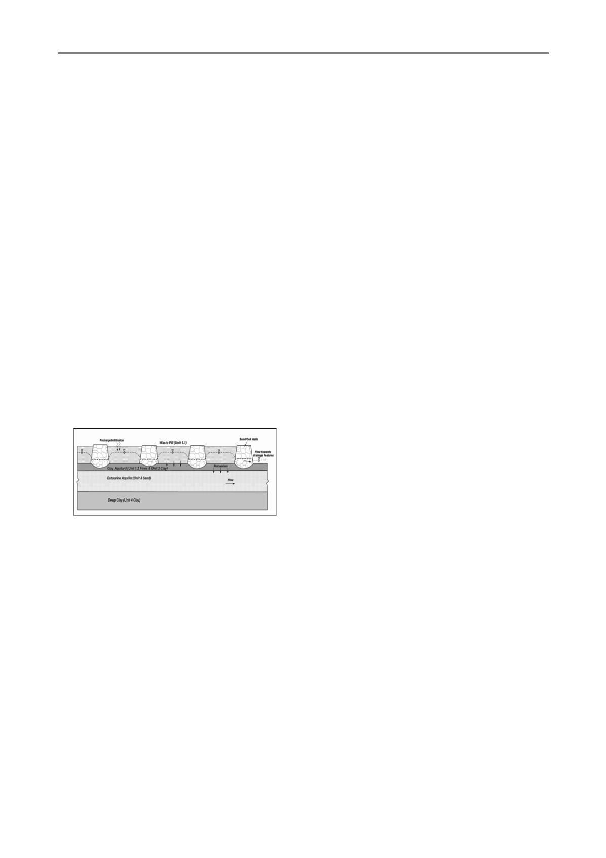
2.2 Hydrogeology
Groundwater beneath the site is known to be present in two
principal aquifers: an upper unconfined aquifer within the fill
strata (Fill Aquifer), and a deeper confined aquifer within the
estuarine sediments (Estuarine Aquifer). The upper soft natural
clays form a slightly ‘leaky’ aquitard that separates these
aquifers. Figure 2 shows a conceptual groundwater model.
Figure 2. Conceptual groundwater model.
As the degree of contamination in the Fill Aquifer is
considerably worse than the Estuarine Aquifer, the continuity
and integrity of the clay aquitard is of important to the hydraulic
and environmental performance of the site.
3 INTEGRATED INVESTIGATION
The investigation of the project site featured integration of
geotechnical, environmental and groundwater aspects to achieve
savings in terms of time and cost. Prior to commencing the field
work program a desktop review was undertaken to collate pre-
existing data on sub-surface conditions and contamination. This
identified data gaps and was used to plan the investigation.
The integration of the disciplines during the investigation
program was achieved by:
Geotechnical boreholes were used to collect samples for
both geotechnical testing and contamination testing.
The use of staff trained in geotechnical logging,
environmental logging and the appropriate collection of
contamination samples.
Extensive use of cone penetration tests, especially
piezocone tests, to better delineate soil stratigraphy, layer
permeability and potential flow paths.
The boreholes were also used for the installation of
environmental grade monitoring wells, so that water samples
could be collected for contamination testing.
Groundwater wells were also used to conduct in-situ
permeability tests in both aquifers
New and existing wells (over 150 in total) were gauged on
the same day to provide a reliable snapshot of groundwater
levels in both aquifers, which could then be used to prepare
groundwater contours that for the first time accurately
represented the groundwater regime of the site.
It was undesirable for the investigations to create hydraulic
connections between the two aquifers, so all boreholes and
CPTs were grouted upon completion to seal the aquitard.
Groundwater modelling was undertaken using MODFLOW
(with Vistas), MODFLOW-SURFACT and PEST for
preliminary parameter estimation. The modelling consisted of
calibration of the model to existing conditions followed by
modelling the effects of site filling, dredging, salinity and
capping the site. Contaminant transport modelling was then
undertaken using CONSIM to assess the potential off-site
impacts of the proposed development.
4 CONTAMINATION
The investigations identified widespread general contamination
and areas of more specific contamination, each with particular
characteristics and potential to impact the environment. The
main contamination issues are described below.
4.1 Tar Waste Ponds
An area known as Ponds 5 and 7 was found to contain large
volumes of non-aqueous phase liquid (NAPL) tar waste to
depths of approximately 8 m. The tar waste is generally in the
form of a viscous sludge containing high concentrations of
polycyclic aromatic hydrocarbons (PAH) and total petroleum
hydrocarbons (TPH). Groundwater impact was also recorded in
wells immediately surrounding Ponds 5 and 7. The groundwater
impact was primarily within the Fill Aquifer, with some
elevated concentrations also recorded in the underlying
Estuarine Aquifer. Key findings included:
Groundwater modelling indicated that the ‘squeezing’
effect of T4 Project loading would lead to temporarily
increased flow of contaminants towards off-site receptors;
Contaminant
transport
modelling
indicated
that
contaminant flow rates would increase during dredging and
preloading of the site, up to twice for naphthalene, compared
to the no development case;
There would be potential for long term off-site migration of
contaminants with or without the T4 Project, however the
risks are higher during dredging and preloading stages; and
Following development over the area of Ponds 5 and 7 (by
the proposed coal stockyard), it would not be practical to
implement mitigation measures, should off-site impacts
become evident.
4.2 Asbestos / Lead Area
The site history review found that an area containing asbestos
burial pits also contained lead dust (from steelworks) co-
disposed with the asbestos in polyethylene bags.
It was assessed that elevated concentrations of lead could
potentially reach the wetlands to the north of the disposal area,
for the following reasons:


