624
Proceedings of the 18
th
International Conference on Soil Mechanics and Geotechnical Engineering, Paris 2013
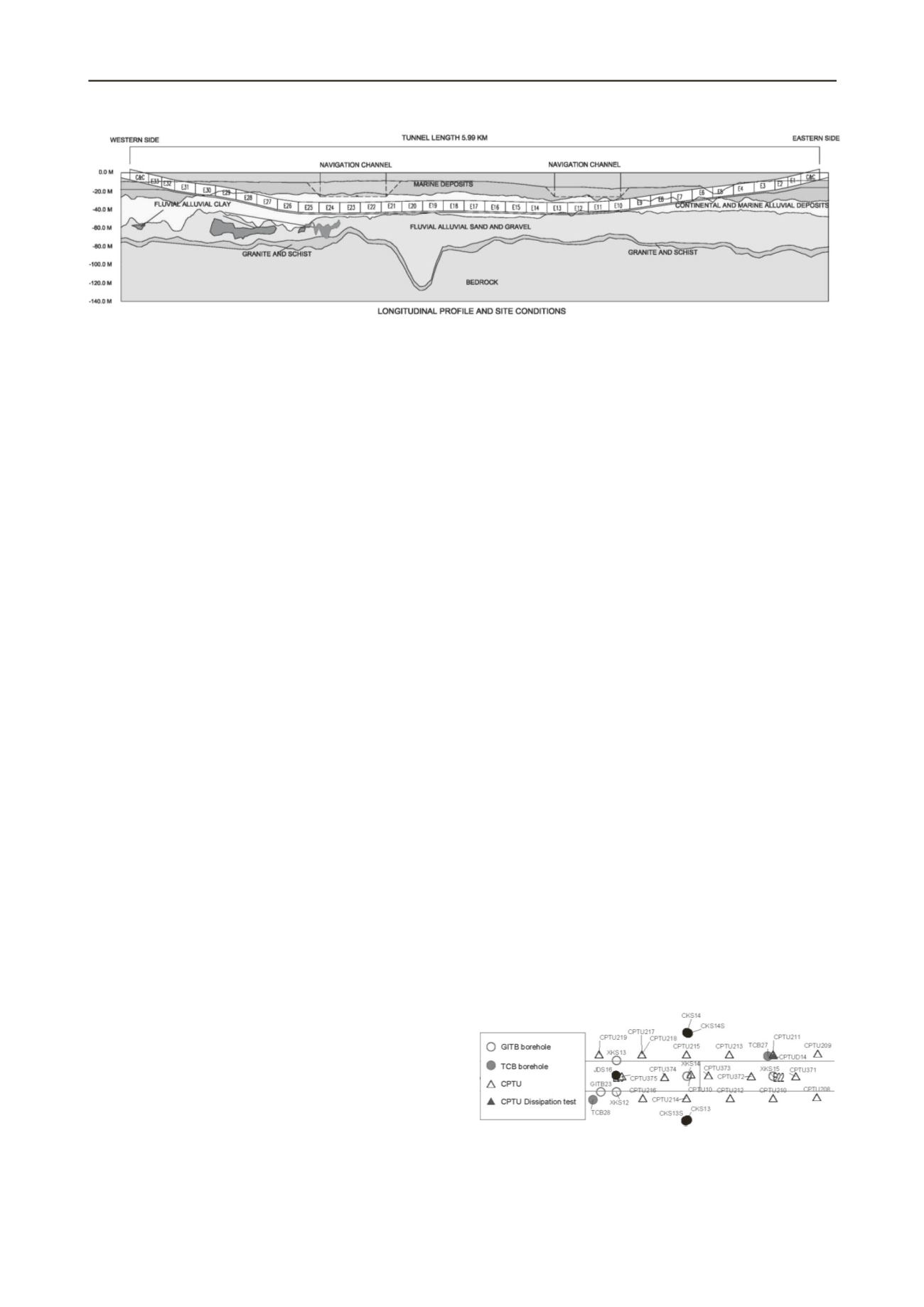
Figure 2. Simplified geological model along the immersed tunnel alignment.
2 GEOLOGICAL CONDITIONS
The project area is located in the Pearl River drainage basin,
which historically has been shaped as a result of the uplift of the
Tibetan Plateau during the Tertiary and Quaternary Periods,
forming the present-day Pearl River Delta with its network sys-
tem and estuarine bays (see Figure 1). The river delta is one of
the most important and complex large-scale estuarine systems in
China.
The Holocene development of the delta has been controlled
and affected by the variations in the deposition of sediments,
sea-levels and groundwater levels.
The soil deposits in the present-day Pearl River delta over-
lying weathered basement rock can be traced back to the Late
Pleistocene and Holocene periods.
These deposits consist of three cycles of upward fining se-
quences of delta deposits, namely one Holocene and two Pleis-
tocene delta cycle, which have been divided by two previously
exposed and subsequently eroded surfaces.
Based on the described regional geology and the findings of
the site investigations carried out for the project, the soil depos-
its and rock formations encountered along the alignment of the
immersed tunnel, and in the locations of the artificial islands,
can be grouped into five main units for soil deposits, and two
main units for rock formations:
Marine deposits of clays and sands formed during the Holo-
cene period,
Continental deposits of clays and sand from a once exposed
surface formed during the late Pleistocene period,
Marine alluvial deposits of clays and sands formed during
the Mid to Late Pleistocene period,
Fluvial alluvial deposits of clays and sands formed during
the Early to Mid Pleistocene period,
Residual soils formed during the Early Pleistocene period,
Highly to completely migmatic schists formed during the
Sinian period,
Moderately to completely weathered migmatic granites
formed during the Sinian period.
A simplified geological model is shown in Figure 2.
3 SCOPE OF INVESTIGATIONS
Three geotechnical investigation campaigns have been carried
out for the project:
Feasibility Study investigations carried out in 2004 and
2008: Only 16 Nos. boreholes were carried out in the vicin-
ity of the immersed tunnel.
Preliminary Design investigations carried out in 2009:
151 Nos. boreholes were carried out for the artificial islands
and 115 Nos. boreholes, 29 Nos.
CPTUs and seismic P-S
suspension logging (in 10 Nos. boreholes) was carried out
along the immersed tunnel alignment.
Supplementary Soil investigations were carried out in 2010-
2011: 80 Nos. boreholes, 364 Nos. CPTUs, 20 Nos.
CPTUDs and seismic P-S suspension logging (in 6 Nos.
boreholes) was carried out along the alignment of the im-
mersed tunnel and at the locations of the artificial islands.
The Supplementary Soil investigations formed the main basis
for Detailed Design, and the scope of and specifications for
these investigations were defined by COWI as being a member
of the design and construction Joint Venture. Site and laboratory
works were followed closely by means of inspections carried
out by COWI's geotechnical engineers, in order to ensure that
all works were carried out in accordance with applicable stan-
dards.
The boreholes for the Supplementary Soil investigations
were split into two types of boreholes: the GITB-series where
geotechnical in-situ testing was carried out and disturbed sam-
ples were retrieved, and the TCB-series that were used entirely
to retrieve undisturbed samples of fine grained soils. Most of
the boreholes were carried out in pairs, each pair consisting of
one GITB borehole and one TCB borehole, and as a general rule
the GITB and TCB boreholes were drilled within five meters of
each other, in order to produce mirror boreholes displaying
similar geological and geotechnical properties. The drilling
depths varied from 29 to 107 m below existing seabed level.
The general distance between boreholes (and borehole pairs)
was on average approx. 200 m in the longitudinal direction.
In general the CPTUs were carried out along three lines par-
allel to the tunnel alignment at distances of 0 m, +25 m and
-25 m from the tunnel axis. The probing positions were stag-
gered (cf. Figure 3), in order to effectively allow for one CPTU
carried out at 25 m spacing along the projected centreline of the
entire immersed tunnel alignment. Furthermore, additional
CPTUs were carried out near the artificial islands. The CPTUs
were carried out to penetration depths varying from 28 to 43 m
below existing seabed level (basically to refusal in the fluvial al-
luvial sands and clays underlying soft deposits of marine clays).
A typical arrangement of investigations along the immersed
tunnel alignment is shown in Figure 3.
The complete results of the Supplementary Soil investiga-
tions were provided by the geotechnical sub-contractors, Fourth
Harbour Design Institute (FHDI) and Fugro, in native AGS 3.1
format.
Figure 3. Typical arrangement of investigations along immersed tunnel
alignment.


