619
Characterization and Settlement Modeling of Deep Inert Debris Fills
Caractérisation et modélisation du tassement de dépôts épais de gravats inertes
Somasundaram S., Khilnani K., Shenthan T.
Advanced Earth Sciences, Irvine, California, USA
Irvine J.
Irvine Geotechnical, Pasadena, California, USA
ABSTRACT: Inert debris fills are difficult to characterize and model by normal geotechnical methods, due to their inherent
heterogeneity, very large particle size, and nested and voided structure. The approach taken to characterize a 54 m deep inert debris
fill, model its settlement behavior under seismic loading and groundwater level rise, and develop remedial measures to render it
suitable for development is presented. Fines migration into open cavities and collapse of nested structure were determined to be the
primary settlement mechanisms for this material. An upper bound estimate of cavity volume vulnerable to fines migration and
collapse was made based on the results of large scale in-situ density and gradation tests. Settlement was estimated for various
percentages of cavities becoming filled, and compared to case histories of dry fill settlement from the San Fernando and Northridge
earthquakes. The proposed remedy involved partial removal of the debris fill and replacement as a compacted fill cap to attenuate the
surface expression of differential settlement occurring in the underlying debris fill. Surface manifestation of settlement was simulated
using FLAC. Charts were developed relating cap thickness to surficial manifestation of differential settlement.
RÉSUMÉ : Les dépôts de gravats inertes sont difficiles à caractériser et à modéliser par les approches géotechniques usuelles, en
raison de leur hétérogénéité intrinsèque, de la grande taille des particules qui les constituent, et de leur structure lacunaire et emboîtée.
On présente une approche utilisée pour caractériser un dépôt de gravats inertes de 54 m d'épaisseur, modéliser son comportement de
tassement sous chargement sismique et sous l'effet d'une montée du niveau de la nappe phréatique, et développer des mesures de
remédiation en vue de le rendre propre à l'utilisation. On a pu montrer que la migration des fines dans les cavités ouvertes, et
l'écrasement des structures emboîtées, constituent les mécanismes principaux responsables du tassement pour ce matériau. Une
estimation par excès du volume des cavités vulnérables par la migration des fines et écrasement a été établie sur la base d'essais à
grande échelle de densité in-situ et de granulométrie. Le tassement a été estimé pour divers proportions de remplissage de cavités, et
comparé à des observations historiques de tassement de remblais secs suite aux séismes de San Fernando et de Nothridge. Le remède
proposé implique un retrait partiel du dépôt de gravats et son remplacement par une couche de remblai compacté, en vue de minimiser
l'expression en surface des tassements différentiels survenant dans le dépôt de gravats sous-jacent. Le déplacement en surface a été
simulé en utilisant le logiciel FLAC. La relation entre l'épaisseur de la couche de protection et l'incidence en surface du tassement
différentiel a été exprimée sous forme d'abaques.
KEYWORDS: inert debris landfills; debris fills; seismic settlemen
1 INTRODUCTION
Inert debris landfills in urban areas are increasingly becoming
potential sites for industrial / commercial redevelopment due to
scarcity of vacant land and a desire by local communities to turn
blighted areas into revenue sources. These fills, generally placed
in abandoned mine pits, could be over 50 m deep and typically
consist of uncontrolled fills of construction and demolition
(C&D) debris. Due to their inherent heterogeneity and very
large particle size they are difficult to characterize and model by
normal geotechnical methods. This case study presents the
approach taken to characterize a deep inert debris fill, model its
settlement behavior under seismic loading and groundwater
level fluctuations, and develop remedial measures to render it
suitable for development.
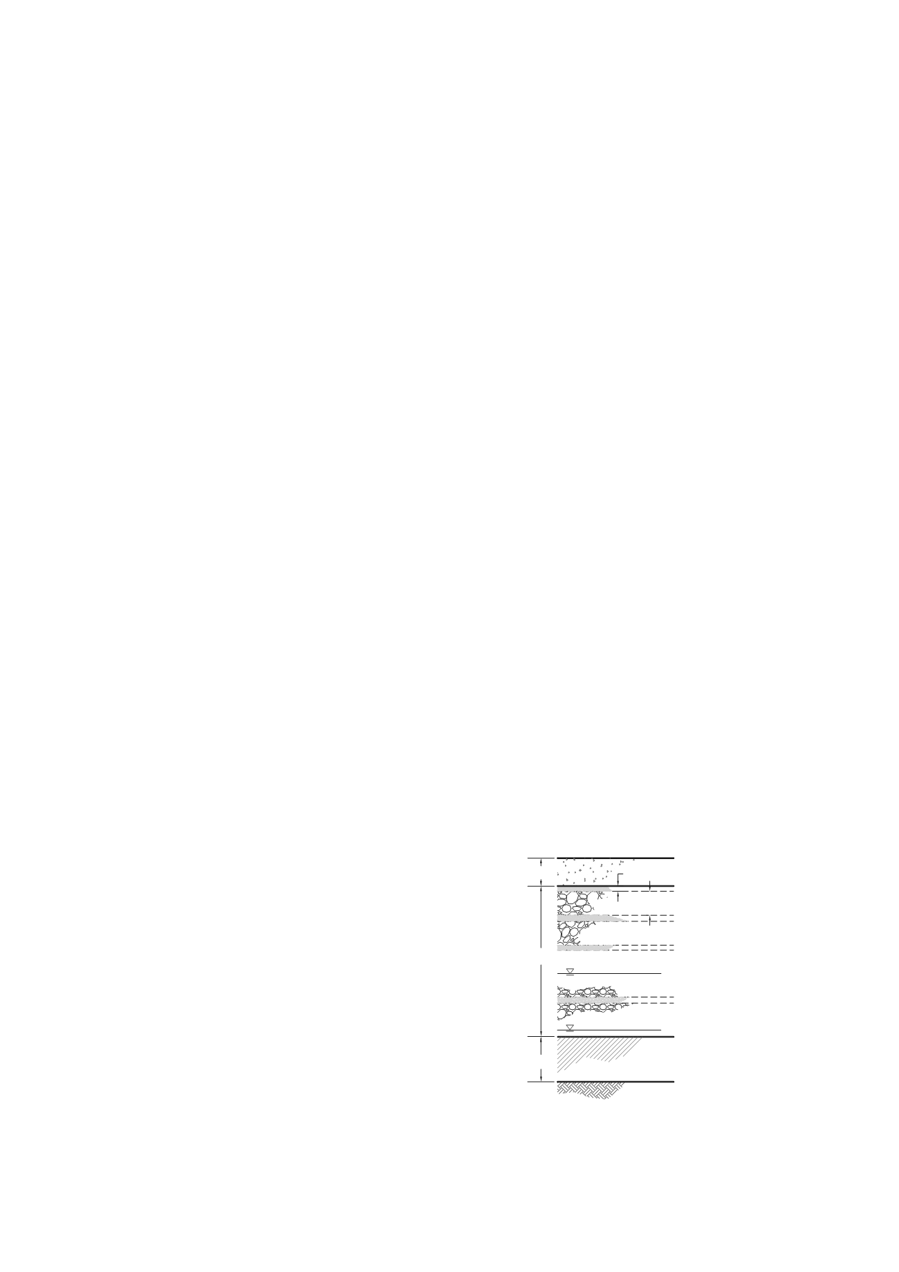
The inert debris fill, located in the City of Irwindale in
southern California, consists of over 8 million cubic meters of
C&D waste placed over a period of 15 years within a 54 m deep
abandoned open pit gravel mine covering a footprint of 22
hectares. The lower 2 to 12 m of the pit was filled with
hydraulically placed silt, a by-product of aggregate mining
operations. Review of placement records indicated that the inert
debris fill above the silt layer consists of a succession of 1 to 3
m thick lifts of rubble consisting mostly of broken concrete,
brick, tile and asphalt capped with 15 to 30 cm thick lifts of
sandy and silty soils. The soil layers were generally placed and
compacted above each rubble lift to provide a suitable surface
for rubber tired traffic. The entire inert debris fill is capped with
a 3 m thick layer of compacted soil to allow for utility
excavation and structure foundation at the finished surface.
Placement records indicate that initially the rubble fills were
placed with some degree of material processing (crushing of
oversize concrete clasts) and compaction. However, much of
the inert debris fill was loosely end dumped with little or no
control of lift thickness, particle size or compaction. The
groundwater level was approximately 36 m below the ground
surface during filling, but could rise by about 12 m based on
historic records. An idealized profile of the fill stratigraphy is
shown in Figure 1.
1 to 3m
Potential highest
groundwater level
Previous highest
groundwater level in fill
150 to 300mm
(24 m below ground surface)
(36 m below ground surface)
Compacted FillCap
(3 m)
Rubble Fill
(Thickness varies)
Silt Deposit
(Thickness varies)
Figure 1. Debris Fill Stratigraphy


