3311
Technical Committee 210 + 201 /
Comité technique 210 + 201
Fig.7. Soil profile near the West –North corner of the reservoir No. 10.
5. THE EMBANKMENTS MATERIAL
The boundary embankments show some special features. As
they were made of slag and ash from the power plant, their
weight is relatively low. Fig.8.
Fig.8. Material of the northern embankment of Reservoir No10 after the
embankment failure.
Their average density is
= 1.5-1.55 gr/cm
3
, while their dry
density is
s
= 0,7-0,8 gr/cm
3
, which is lower than that of water.
The embankment is quasi-saturated with water. Due to the
hydraulic chemical bond, the embankment is characterised by a
relatively large strength. As a result of the construction
technology applied, the embankment is layered and is of
inhomogeneous structure, which manifests both in its strength
and its water permeability characteristics.
6. PROPERTIES OF THE “RED MUD”
The description of the substance as „red mud” is not appropriate
in terms of soil mechanics, as considering plasticity index, it
belongs to the group of substances of medium to high plasticity
and should be described as medium and fat clay.
Chemical effects, such as that of sodium hydroxide added to the
swollen clay in the course of the technological process, may
also have a role in the special behaviour of “red mud”.
It can conclusively be stated that the substance shows special
thixotropic behaviour, it does not easily lose its water content
and assumes the behaviour of a thick, plastic liquid upon
significant loading. (Asbóth et al 1982.)
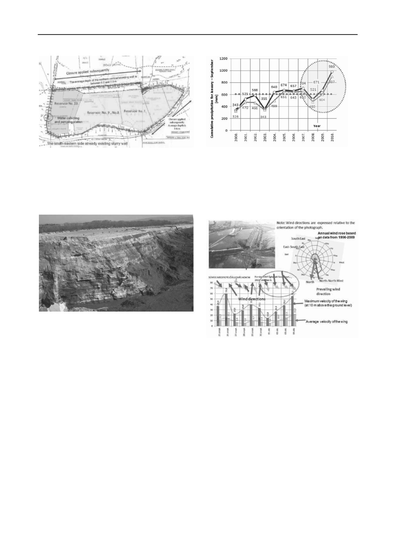
7. PRECIPITATION DATA
Comparing the total precipitation of the period between January
and the end of September 2010 was 907÷980 mm, comparing
the average of the 2000-2009 years data 513÷567 mm with
121÷131 mm standard deviation. (Fig 9.)
Fig.9. Total precipitation data in the 1st– 3rd quarter year between 2000
and 2010.
8. WIND SPEED AND WIND DIRECTIONS
The prevailing wind direction in the vicinity of Reservoir No.
10 is northern–north-western as shown in the wind direction
frequency chart. Wind parallel with the direction of the
embankment failure is very rare (Figure 10).
Fig.9. Vectors of prevailing wind directions and wind speeds between
September 25.
Peculiar wind conditions were observed in the area between
September 25 and October 4. Between October 1 and 4, a
gradually strengthening, unfavourable wind speed toward the
direction of the embankment failure was accompanied by casual
wind gusts (Weather data services, National weather Services,
October 8, 2010). The observations of the wind direction and
speed were at 10 m over the ground surface, but the top surface
the reservoir is 23-24m. It is mean that the wind speed in site
should be significant more than the measured value. The highest
wind speed values were measured on October 4, with an
average of 22 km/h and occasion wind gusts of 60 km/h.
There is reason to assume that these unusual wind direction and
wind speed conditions contributed to the development of the
embankment failure. The sucking effect of the wind on the
northern side of the embankment must be taken into
consideration.
8. CIRCUMSTANCES OF THE EMBANKMENT FAILURE
The area is located in the lowest part of the drainage basin of
the Torna stream, i.e. in the valley of the stream. In its original
condition, the area, together with the subsurface stream valley
formed a surface and subsurface water flow unit which was very
sensitive to weather conditions. The area had been gradually
involved in and shaped by industrial operations, through the


