3310
Proceedings of the 18
th
International Conference on Soil Mechanics and Geotechnical Engineering, Paris 2013
short time. 10 people died, 123 injured, 260 houses became
uninhabitable, and significant ecological damage occurred.
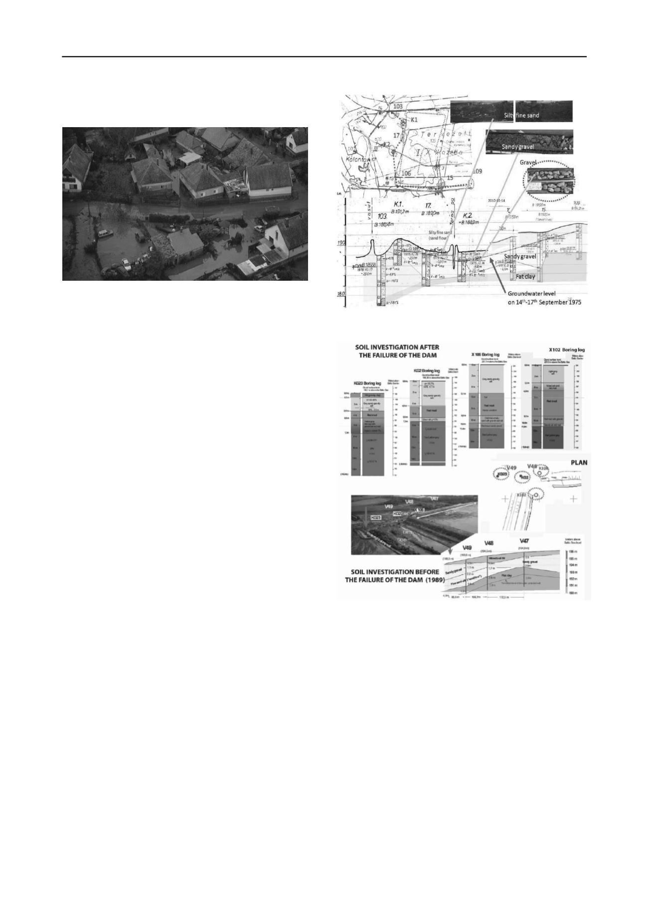
Fig.4. Aerial photo with the flooded territory of Kolontár (photo: MTI)
2 GENERAL CONDITIONS
The embankment of the reservoir in question must be examined
as part of the entire reservoir system, as the different parts of the
system have a mutual impact on each another. The tragic tailing
dam failure of the north-western corner of reservoir No. 10
highlighted the importance of a complex analysis.
Important aspects of the study are:
• the geological-geotechnical conditions and the morpholo-
gical properties of the area;
• the conditions changed as a result of favourable technical
interventions or technical interventions believed to be
favourable;
• the extreme weather, precipitation and dynamic wind load
conditions;
• the specific features of the substance stored in the
reservoirs;
• the resistance reducing effects of pressures due to the
transition of the substance from a more favourable condition
to an unfavourable state of liquefaction;
• the different rigidity properties of the unfavourable
embankment connections;
• and several other factors that could not have been
considered by earlier regulatory systems.
3 HYDROGRAPHICAL AND SUBSOIL CONDITIONS
Figure 5 shows the subsoil conditions of the area based on
detailed soil tests performed between 1975 and 1980. The
territory had a basin-like character, fill with course gravel and
sand and cover fine sand and silt, hence is had a swampy
character, collected the water. The gravel terrace is gradually
thinning towards the northern embankment. The „gravel basin”
is bounded by a soft, easily liquefiable sludge layer of a
plasticity index of Ip=6.8-8.5% and a water permeability of
k=10
-5
cm/sec.
In the year 1989 soil excavations and geophysical
measurements were conducted at the leg of reservoir No. 10.’s
tailing dam, and the soil profiles were recorded. Figure 6 shows
the soil profiles near the north-west corner. It is important to
remark that near the north-west corner of reservoir No.10 sand-
silt soils are to be found, and sandy-gravel layers above the fat
clay. This soil layer unfavourable is that in fine sandy-silt
fractions may move under higher water pressure conditions.
Fig.5. Illustration of the subsoil conditions of the reservoir system based
on the original plans.
Fig.6. Soil profile near the West –North corner of the reservoir No. 10.
As a result, grain size becomes coarser on the inner side, while a
„clay plug” may develop towards the edge of areas in motion.
Such a clay plug is characterized by a sudden movement under
a significant change in pressure and consequently a mudflow-
like grain movement may evolve. Such a process may be
extremely fast and unexpected.
4. THE CLOSURE OF THE RESERVOIRS
Water pollution was detected in the groundwater monitoring
wells near the reservoir system in the 1970s–1980s. In
compliance with the regulatory requirements, a watertight slurry
wall was constructed to close down the southern and the
western sides of the reservoir. Figure 7.
Later, as the pollution spread over towards the north, the
construction of a new type of grout curtain was started around
the reservoir system in 1999. Depths of 6.0-9.0-12.0 m appear
on the south-eastern side.


