2321
Technical Committee 209 /
Comité technique 209
1.3
Project Construction Phase
During the construction phase, geotechnical activity is
typically limited to quality assurance testing which serves to
confirm and ensure that the design assumptions remain valid.
This is the phase where risks missed during the earlier phases
may become apparent with the potential for project cost
overruns.
Rarely would geotechnical input in this phase result in cost
savings. However,
value engineering
where the balance of plant
(BOP) contractor is provided an opportunity to redesign is
becoming more popular. Value engineering often occurs shortly
before construction or as the BOP contractor is mobilizing to
construct the project. Ironically, the likely reason for value
engineering is the tendency of the original designer to err on the
conservative side because of compressed schedules and/or lack
of substantive geotechnical basis of design at the end of the
development phase, creating opportunities for the BOP
contractor to cut costs at the last minute.
1.4
Summary of Current and Proposed Practice
Table 2 shows a summary of current and proposed practice.
The essence of the proposed redistribution of the geotechnical
exploration effort is to advance the geophysical survey and the
preliminary investigation to the development phase (P1). Details
of the geotechnical activities for the proposed redistribution are
shown in Table 3.
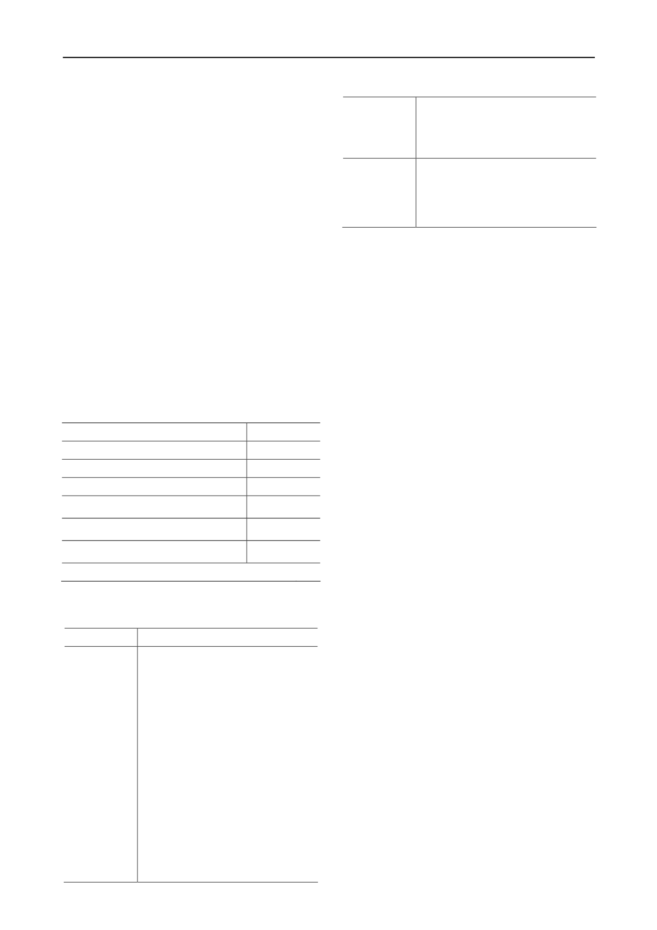
Table 2. Common and proposed geotechnical effort.
Common
Proposed
Phase
P1 P2 P3 P1 P2 P3
Desk study
X
X
Geophysical survey
X
X
Preliminary investigation
X
X
Full investigation
X
X
Assurance & validation
X
X
Phases: P1 = Development, P2 = Design, P3 = Construction
Table 3. Wind farm realization phases and proposed geotechnical
ctivities.
a
Phase
Proposed minimum geotechnical activities
Development
Desk study:
o
Often required for permitting but
can be useful in planning
preliminary investigation
Geophysical Survey
o
All turbine locations except
possibly sites where rock is at the
surface
o
Useful for micrositing
Preliminary Investigation
o
Drilling at a subset of turbine
locations distributed strategically to
capture maximum variability
o
Excavation pits along potential
access road alignment
o
Electrical and thermal resistivity
testing
o
Limited laboratory testing
Design
Full Investigation
o
Drilling at all turbine locations
o
Extensive laboratory testing
o
Fill all gaps to form design basis
Construction
Construction QA/QC
o
Confirm validity of design
assumptions
o
Ensure compliance with design
requirements
2 SOURCES OF UNCERTAINITY
Wind energy projects differ from most traditional projects in
that they cover large terrains. Wind turbines are typically placed
5 to 10 rotor diameters apart to optimize energy extraction
(Denholm et al. 2009). Nowadays, typical rotor diameter for
large wind turbine generators is around 120 meters, signifying
turbine spacing of 0.5 to 1 kilometer just for energy extraction
efficiency. Therefore, wind turbines are too far apart to
consider any relationship between ground conditions from one
turbine location to another. This is separate from regional or
larger scale characteristics which may be applicable to the
project area or portions of it, such as those related to different
geologic settings or terrains. Turbine structures themselves are
also unique due to the nature of loading they impart to
foundations and supporting soils in terms of type, magnitude
and variation. Thus, in addition to increased uncertainty due to
essentially independent conditions at turbine locations, these
projects also require parameters unique to these structures such
as those needed to ensure adequate foundation stiffness.
Generally, there are three main sources of uncertainty in a
geotechnical design property: i) inherent soil variability, ii)
measurement error, and iii) transformation error (see Baecher
and Christian 2003, Phoon and Kulhawy 1999). Often, a design
parameter is not measured directly in-situ or in a laboratory test
but is calculated based on other measured properties. Two of the
above sources (inherent variability and measurement error) are
associated with the measured property. The third source is
associated with uncertainty in the selected transformation
model, i.e., the empirical or theoretical relationship used to
calculate the design property from the measured properties.
Point estimates, as well as spatial variability of various shear
strength, mechanical and index properties, are available in the
literature (e.g., Lee et al. 1983). This information can be used to
select the test methods that result in lowest variability
depending on the soil type. In this section, uncertainty sources
are discussed in more detail as they relate to wind energy
projects.
2.1
Uncertainty Due to Inherent Soil Variability
Inherent soil variability is related to the natural geologic
processes that produced the soil and should not include the
influence of deterministic trends (e.g., trends due to depth),
mixing of soils from different geologic units, or measurement
errors. In the case of wind projects, inherent variability should
be considered at each individual turbine location.
Another source of uncertainty is related to spatial variability
extending vertically and horizontally to dimensions of
influence. Uncertainty related to spatial variability is affected by
the scale of fluctuation or correlation distance which is an
important statistical parameter loosely defined as the distance
within which the values of a given parameter are significantly
correlated (Fenton and Griffiths 2008). Due to the often layered
nature of soils, the correlation distance is typically shorter in the
vertical direction than in the horizontal direction. Engineering
design practice, including that within the wind energy industry,
considers single (or point) variables to represent properties of an


