2240
Proceedings of the 18
th
International Conference on Soil Mechanics and Geotechnical Engineering, Paris 2013
3.3
Reduction factor of the soil shear strength
A quantitative assessment of the relationships between different
factors (i.e. slope angle, failure depth and water table depth) and
reduction factor of soil shear strength due to earthquake was
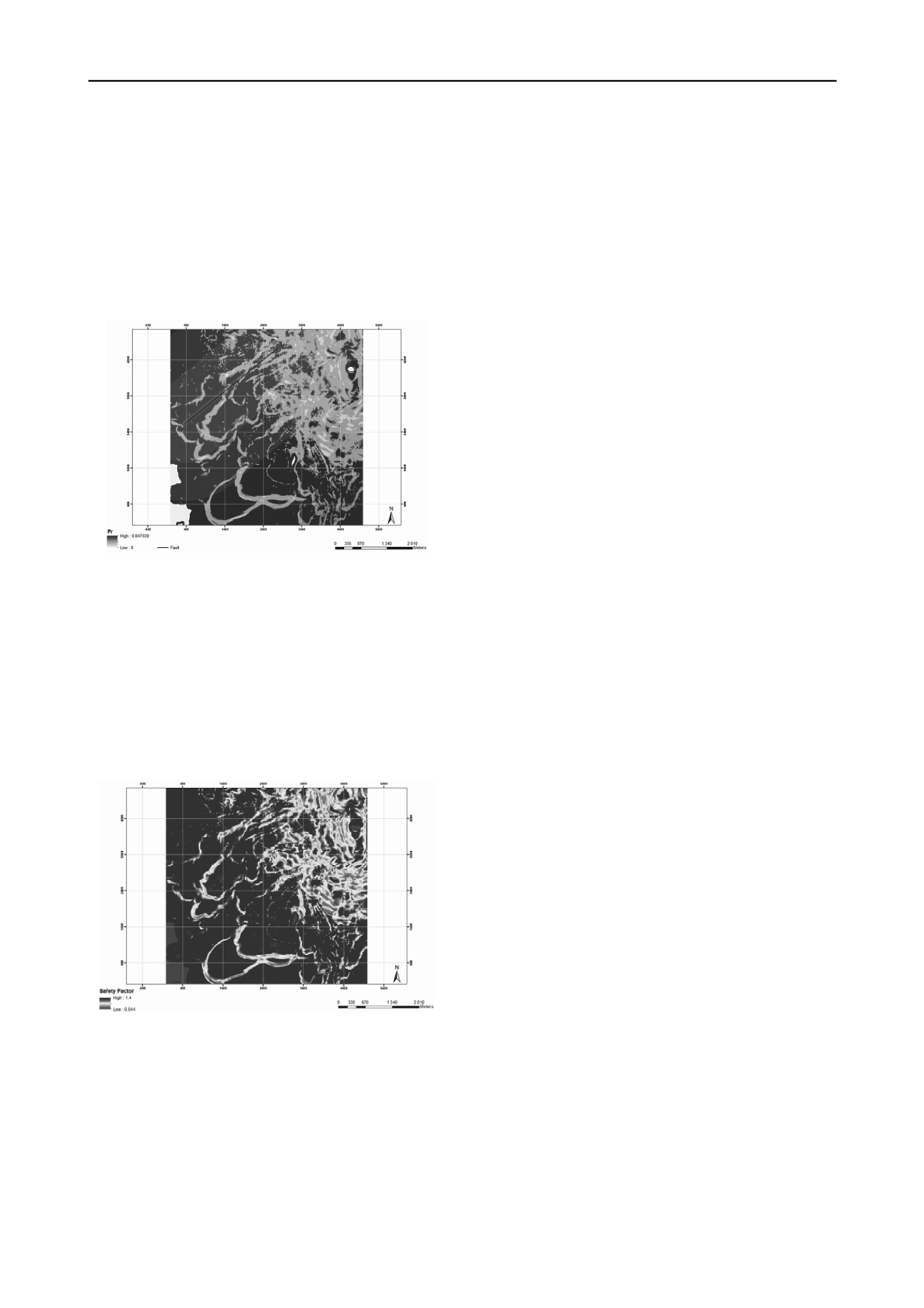
performed. Figure 5 shows the areal distribution of the reduc-
tion factor of the soil shear strength considering a rainfall inten-
sity of 120 mm a day. The bedrock is assumed to be much less
permeable than the soil cover. Soil depth varies from 4 to 7 m
depending on the type of soil and topographic characteristics in-
side the virtual region.
For this reason, a model that includes the reduction of the
soil strength parameters induced by the strong motion of an
earthquake was developed and implemented. A virtual case
study was performed to assess the behavior of the model and its
parameters. This was achieved by calculating two reduction fac-
tors that represented the reduction of rainfall threshold in space
and time, and the reduction of the soil strength due to prevailing
conditions.
There are still some limitations regarding the model and fur-
ther validation needs to be done. A thorough calibration of the
reduction factors should be done locally and the possibility of
using real events that are well documented should be consid-
ered. However, despite its limitations, the model provides a
practical approach to assess the prospective outcomes of future
hazards and their interactions. Thus the model contributes to in-
creasing the knowledge required for the protection of the people
at risk and their assets.
5 ACKNOWLEDGEMENTS
The research leading to these results has received funding from
the European Community’s Seventh Framework Programme
[FP7/2007-2013] under Grant Agreement No 265138 New
Multi-HAzard and MulTi-RIsK Assessment MethodS for
Europe (MATRIX).
Fig. 5 Spatial distribution of the soil shear strength reduction factor
(fr).
6 REFERENCES
3.4
Slope stability assessment including the reduction factors
A two dimensional equilibrium stability analysis based on the
infinite slope model was carried out in order to compute the
new factors of safety that included the reduction factors. The
mean values of the logarithmic distributions functions of the in-
put parameters were applied in the analyses. A constant porosity
of 42% and an evapotranspiration of 5 mm/day were selected
throughout the area. Five different friction angles were used for
the different soil types: 30, 32, 34, 36, 38°. Figure 6 shows the
results of the stability analysis considering the reduction of the
soil strength after an earthquake.
Bovolo, C. I., Abele, S. J., Bathurst, J. C., Caballero, D., Ciglan,
M., Eftichidis, G., Simo, B. 2009. A distributed framework
for multi-risk assessment of natural hazards used to model
the e_ects of forest _re on hydrology and sediment yield.
Computers & Geosciences
35(5): 924 - 945.
Delmonaco, G., Margottini, C., Spizzichino, D. 2006.
ARMONIA methodology for multi-risk assessment and the
harmonisation of different natural risk maps.
Deliverable
3.1.1, ARMONIA
Iverson, R. M. 2000. Landslide triggering by rain infiltration.
Water Resources Research
, 36(7), 1897-1910.
Kappes, M., Keiler, M., Glade, T. 2010. From single- to multi-
hazard risk analyses: a concept addressing emerging chal-
lenges. In Malet, J.-P., Glade, T. & Casagli, N. (Eds.),
Mountain Risks: Bringing Science to Society
. Proceedings
of the International Conference, Florence. CERG Editions,
Strasbourg, 351-356.
Keefer, D. K. 1984. Landslides caused by earthquakes.
Geo-
logical Society of America Bulletin
, v 95, pp. 406 – 421.
Khazai, B., Sitar, N. 2003. Evaluation of factors controlling
earthquake-induced landslides caused by Chi-Chi earth-
quake and comparison with the Northridge and Loma Prieta
events.
Engineering Geology
, 71, pp. 79 - 95.
Lin, C.W., Shieh, C. L., Yuan, B. D., Shieh, Y. C., Liu, S. H.,
and Lee, S. Y. 2004. Impact of Chi-Chi earthquake on the
occurrence of landslides and debris flows: example from the
Chenyulan River watershed, Nantou, Taiwan.
Engineering
Geology
, 71, 49-61
Fig. 6 Stability analysis considering the loss of strength of soil due to the
perturbations caused by a magnitude 6.98 earthquake.
Shou, K. J., Hong, C.Y., Wu, C.C., Hsu, H. Y., Fei, L. Y., Lee,
J. F., Wei, C. Y. 2011. Spatial and temporal analysis of
landslides in Central Taiwan after 1999 Chi-Chi earthquake.
Engineering Geology,
123, pp. 122 – 128.
Tang, C., Zhu, J., Li, W. L. 2009. Rainfall-triggered debris
flows following the Wenchuan earthquake.
Bulletin of En-
gineering Geology and the Environment,
68, 187-194.
4 CONCLUSIONS
A natural system is not just the sum of its components but is the
result of many interacting parts. Hence, a multi-hazard assess-
ment should address evolving characteristics in space and time.
These characteristics can, for analysis purposes, be analyzed as
the alteration of the susceptibility and the triggering mechanism.
A multi-hazard assessment offers the advantage to consider a
slightly larger part of the overall system. The major challenge is
to identify the relationships among the interacting factors and
establish the respective links.


