2164
Proceedings of the 18
th
International Conference on Soil Mechanics and Geotechnical Engineering, Paris 2013
3 FIELD MONITORING & STABILITY ANALYSIS
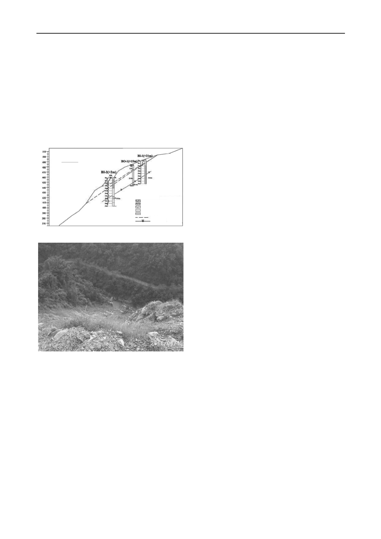
The potential uphill sliding masses (Figure 11).
The unprotected downhill slope surface that enhanced rainfall
infiltration and surface runoff erosion.
In the following few years after Typhoon Longwang, the annual
precipitation of the site was decreasing. To date the road section
and its adjacent slopes appear competent for maintaining local
traffic. However, data from subsurface exploration and in-situ
monitoring during the previous remedial works showed signs of
slope instability at the site (LEC 2006). Figure 11 indicates
potential sliding masses (slip surfaces) in the upslope that would
have impact on the Mileage 39Km road section. The downhill
side slope was not improved during the remedial works and its
surface was bared with remains of previous slides, as shown in
Figure 12.
A long-term erosion of slope toe by Do-Tzuo Creek (Figure
12).
The abundance of groundwater that was observed seeping out
of the surface of downhill slope.
The prolonged and intense rainfalls that infiltrated, saturated
and softened the slope materials, increased the perched water
level, and directly triggered the slips.
4.2
Long-term stability considerations
The previous remedial works at site after Typhoon Longwang
has been successful to date. However, the work details were
mainly for improvements on surface protection of the upslope.
From the analysis above on causes of slope failure, the current
remedial activities would be helpful to mitigate the infiltration
of rainfall and possibly prevent the triggering of a slide in the
upslope. It would not be useful, however, for the stability of
downslope, and would not either remove the concerns (i.e.,
potential factors) above that could be detrimental to the long-
term stability of the road section and slopes at the site.
Mt. Ali Road 39Km
Section C‐C’
Elev.
(m)
SandyGravel
SiltyGravel
SiltySand
Sandstone
Sandstone/Shale
PotentialSlipSurface
Groundwater Level
In accordance, more stability considerations and measures need
to be taken to ensure the safety of the road section, and to
maintain the transportation function of Mt. Ali Road as well.
The considerations might include:
Removal of potential sliding masses or reducing slope angle
in the uphill.
Figure 11. Material strata and potential slip surfaces at Mileage 39Km.
Downhill slope protection including vegetation and drainage
installations.
Road base and adjacent slopes strengthening by piling and
anchoring.
Subsurface drainage installations in uphill & downhill slopes.
In-situ monitoring and warning system installation.
The above measures appear to be sound from an engineering
standpoint. However, the total cost and time for all of the above
works would be extremely high, in view of difficulties in access
for construction and generally incompetent subsurface materials
at the site. Another option would appear more favorable as to
reroute the Mt. Ali Road away from this difficult section.
5 ACKNOWLEDGEMENTS
The authors would like to thank District V, Directorate General
of Highways, Taiwan, for providing documents for this study.
Figure 12. Downhill slope of Mt. Ali road section at Mileage 39Km.
4 CONCLUSIONS
6 REFERENCES
In view of past failure incidents and associated remedial works,
the road section at Mileage 39Km and the alongside slopes are
still at perceivable risks of a potential slide. The signs of slope
instability appeared to be pronounced since the attack of 1999
Chi-Chi Earthquake, which was believed that the shaking had
weakened the underlying geologic units and thus accelerated the
weathering process of materials at the site.
China Engineering Consultants, Inc. (CECI). 2005.
Engineering
planning and budget estimate for slope mitigation at Mileage 39Km,
Mt. Ali Road, Taiwan
. The 5
th
District, DGH/DOT, Taiwan.
Department of Transportation (DOC). 1996. Taiwan Province
Government. 1996.
Documentary of Typhoon Herb
.
Conclusions on causes of slope instability and measures of
slope mitigation for this site can be drawn and discussed below.
Directorate General of Highway (DGH). Taiwan. 2005.
Emergency plan
for mitigation of slope failure at Mileage 39Km, Mt. Ali Road due
to Typhoon Talim
.
Land Engineering Consultants, Co. (LEC). 2006.
Report on land survey,
subsurface exploration, and in-situ monitoring for slope failure at
Mileage 39Km, Mt. Ali Road, Taiwan
.
4.1
Potential & triggering factors
From a retrospective stand point, the factors that had caused
instabilities of slopes at Mileage 39Km road section could be
attributed to the following:
Liu S.D. and Tseng J.J. 2000.
Investigation report on geology and
landslides along Mt. Ali Road, Taiwan
. Central Geology Survey,
MOE, Taiwan.
A complex geologic structure at the site (Figure 1) where the
underlying geologic units are generally fractured.
National Center for Researches on Earthquake Engineering (NCREE).
2000.
Investigation report on geotechnical engineering damages
due to September 21, 1999, Chi-Chi Earthquake
. Taipei, Taiwan.
The 1999 earthquake shaking that had weakened underlying
geologic structure and enhanced deterioration process of the
materials.
Peng K.Y. 2009.
A study on groundwater fluctuation and geology
structure through rainfall and well pumping
. MS thesis, NYUST,
Taiwan.
Sinica, Taiwan, ROC. 1999.
The steep downhill slope geometry (60° angle & 200m deep).


