2162
Proceedings of the 18
th
International Conference on Soil Mechanics and Geotechnical Engineering, Paris 2013
Figure 2. Geologic cross-section at the 39Km project site (CECI 2005).
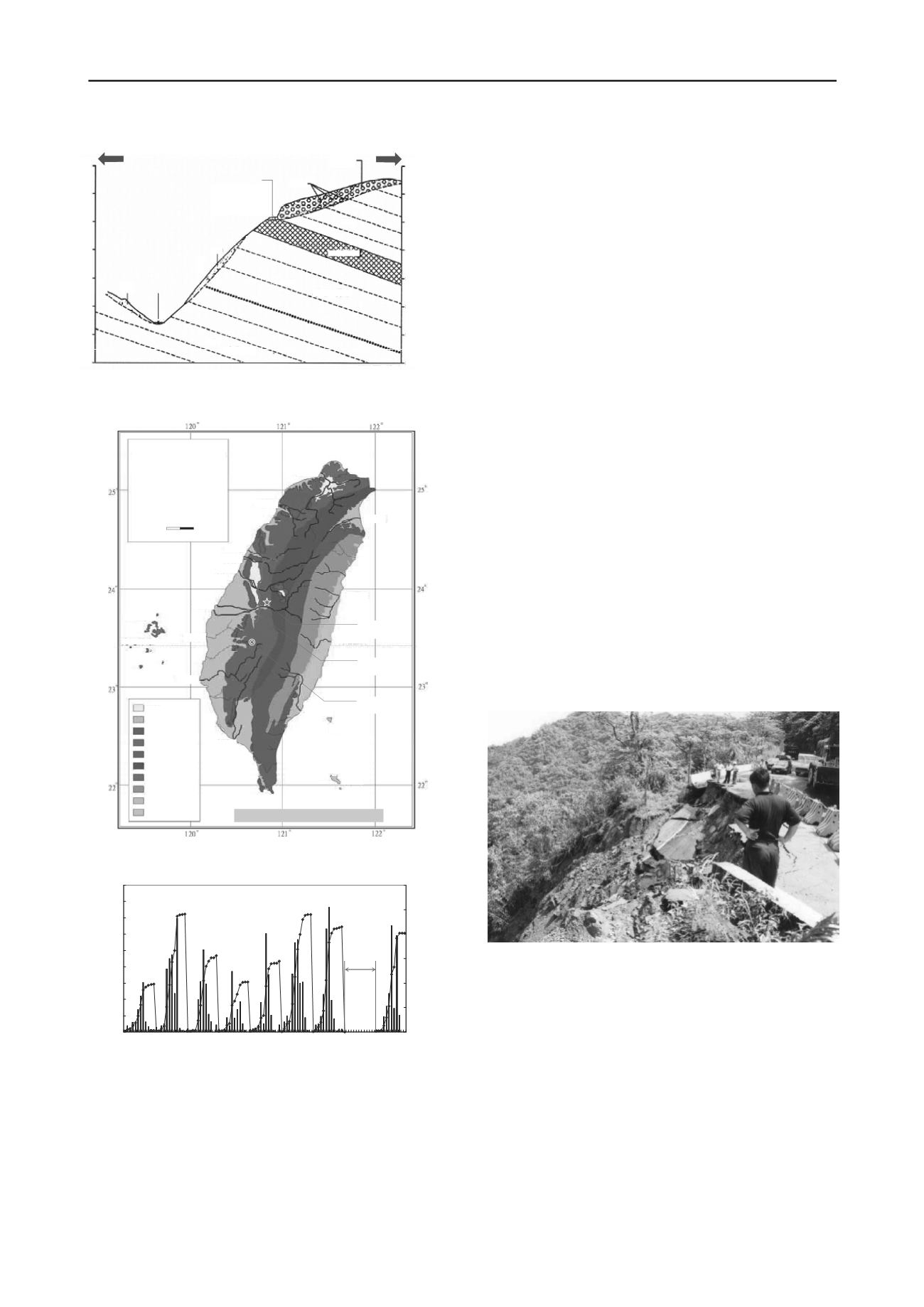
Figure 3. Locations of landslides due to Chi-Chi EQ (NCREE 2000).
Figure 4. Monthly and accumulated rainfalls at the site (Peng 2009).
2 SLOPE FAILURE & ROAD REPAIR HISTORIES
Prior to failures of the subject slopes, a sever typhoon (Herb)
with a rainfall of about 2000mm attacked Taiwan in 1996 and
resulted in significant damages in central region of the island.
Based on an official investigation report, the event had caused
91 landslips and 57 losses of road base along the entire length of
Mt. Ali Road (DOT 1996). However, the subject road and its
slopes were only experienced very minor effects due to this
typhoon and had no influence on the slope stability.
Mt. Ali Rd
Surface
Cracks
Colluvium
Colluvium
Du‐Tzuo
Creek
Colluvium
E
W
SS/SH
SS/SH
SS
Fractured
550
500
450
400
350
300
250
200
Elev.
(m)
550
500
450
400
350
300
250
200
Elev.
(m)
Three years after the severe typhoon incident, a damaging
earthquake (Chi-Chi, 1999) occurred. As mentioned previously,
the earthquake had resulted in numerous landslips in central
Taiwan. Although the site and its adjacent slopes appeared to be
competent during the shaking, the in-situ earthen materials were
apparently weakened and deteriorating due to the earthquake. In
subsequent years, signs of slope distress and movement became
obvious, and some key events and associated repair histories are
discussed in the following sections.
2.1
2001 Typhoon Nari
Typhoon Nari swiped Taiwan in September, 2001, and brought
about 1400mm precipitation to the site, 4700mm for the entire
year. This had been the largest rainfall event since the attack of
Typhoon Herb in 1996. The site had experienced a series of
parallel cracks of 10~80cm in width along the road alignment
which called for a temporary shutdown for one lane of the road.
############
# ##### #
##
#
# ###
#
#
### #
##
# ##
#####
##
#
###
#
### ## ##
# ## ##
#
# ## #
#
###
#
####
####
#
#
#
##
#
##
##
###
#
######
#
#####
#########
### #
##
#
##########
## # ##
#
##
Geology Zonation Map
of Taiwan
(By Prof JJ Hung/NTU/1997)
+
Landslip Location Map
Due to 1999 Chi-Chi EQ
A remedial action was subsequently taken by District V of
Directorate General of Highways (DGH), Taiwan, that included
the repair of surface cracks by a new AC paving and a planning
on reconstruction of the road section by conventional retaining
structure on the downhill side of the road.
2.2
2002 monsoon rainfalls
As the reconstruction work for the retaining structure was about
to start in 8 months after Typhoon Nari, a failure in downslope
of the road occurred (Figure 5). The failure was apparently due
to the intense rainfall during the monsoon season. Recorded
accumulated precipitation was greater than 1000mm within the
two months prior to the failure.
Figure 5. Slope failure at Mileage 39Km due to 2002 monsoon rainfalls.
The original construction work had to be terminated and re-
planned. In view of steep downslope and insufficient road width,
DGH had once considered remedying the problem by cutting
back and flattening the upslope. However, the plan was turned
down due to unsuccessful negotiations with local ownerships of
lands adjacent to the road.
The remedial plan was finally decided to limit within the extent
of the road owned by DGH. Considerations of the road redesign
had included a section of box-type concrete structure, as shown
in Figure 6, which would provide a design with enough road
width, structure rigidity, and relatively light-weight. The box
structure was secured to the native ground by two rows of
ground anchors, each of which with a total length of 35m, a
horizontal spacing of 20m, and an anchor force of 45T. The
#
#
#
Y
¾_¥¡
#
# #
##
####
###
#
#
#####
###
#
#
#
#
#
#
####
#
###
Dumsui
River
Fong‐Shan
River
I‐LanRiver
0
30 Km
Dar‐Ann
River
Dar‐ChiaRiver
Basin
Plain
Tableland
IgneousRock
SedimentaryRock
Metamorphic Rock
(Quartzite,Argillite)
Metamorphic Rock
(Slate,Phyllite)
Metamorphic Rock
(Schist,Marble,Gneiss)
TaitongValley
East CoastHillside
Note:
#
Landslip Locations / Chi‐Chi EQ
Dar‐Doo River
Hualien
River
Tzuo‐Swei
River
Pei‐Kang
River
Tzen‐Wen River
Kao‐Ping
River
Bay‐Nan
River
Green Island
Orchid
Island
Siu‐Gu‐Run
River
Pen‐Hu
Islands
Epicenter
Chi‐Chi EQ
Tropic ofCancer
Chelungpu
Fault
The Site
(39K)
2000/01~2008/12月降雨與累積降雨
0
200
400
600
800
1000
1200
1400
1600
1800
2000/1
2000/6
2000/1
2001/4
2001/9
2002/2
2002/7
2002/1
2003/5
2003/1
2004/3
2004/8
2005/1
2005/6
2005/1
2006/4
2006/9
2007/2
2007/7
2007/1
2008/5
2008/1
日期
月
降
雨
量
月雨量 各年累積雨量
(mm)
0
1000
2000
3000
4000
5000
6000
年
累
積
雨
量
(mm)
Monthly & Accumulate Annual Rainfall (01.2001~12.2008)
2007年
無資料數據
Monthly Rainfall (mm)
Accumulate Annual Rainfall (mm)
Data
Missing
Date


