2174
Proceedings of the 18
th
International Conference on Soil Mechanics and Geotechnical Engineering, Paris 2013
two more in soil and rocky mass (SPT / Core boring–RQD). All
boreholes the SPT was measured for each 0.5 m, in general with
a depth of 10 to 15 m, but some went down to 20 m (SM-01,
SM-02 and SP-02). Geological characteristics were identified
together with soil / material descriptions.
In general, for all borehole tests performed, the SPT values
ranged from 2 to 17 down to a depth of 7 m from the level of
the natural ground surface, within the limits of the two
geological formations. From this point on, the SPT values
increase markedly, up to an order of 30, until becoming
impenetrable to the SPT borehole. In the vertical profile, soil
types vary from clayey sand, to sandy clay, silty sand, and
sandy silt, with the layers varying in thickness, and showing the
presence of increased amounts of sandy materials. The greatest
alterations in SPT values were found very close to the Barreiras
Formation contact with the granite residual soil. An exception
involved the SP-02 borehole, found to be basically granite
residual soil (Figure 1). Due to high sand content, the Barreiras
Formation in the area is identified as an alluvial plain facie.
Based on technical interpretation, the failure surface was shown
to be near to the geological formation contact point, later
confirmed by instrumentation (inclinometer results).
The presence of granite residual soil from the ground level
in the SP-02 region demonstrated a profound influence on the
landslide process, as evidenced later on in the study.
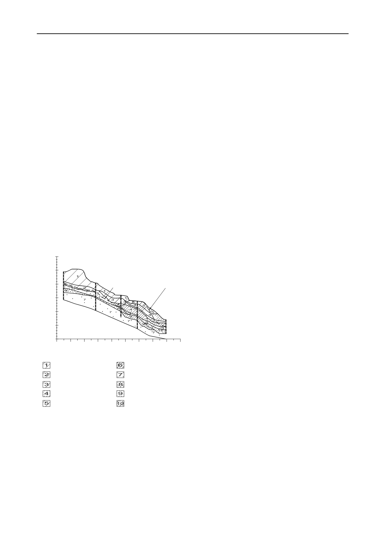
Soil profile cross-sections were detailed from the subsurface
exploration, along with results from geological engineering
mapping. Typical soil profile information is shown in Figure 1.
Contact of Barreiras Formation and Residual Soil
25
30
35
40
45
50
55
0 10 20 30 40 50 60 70 80 90
SM-01
SM-02
SP-01
SP-02
SP-03
Distance (m)
Elevation (m)
Clayey sand dark yellow / BF
Sandy clay light gray / RS
Clayey sand light gray and dark red / BF
Clayey sand light gray
Clayey sand dark yellow / RS
Sandy silt clay
Sandy clay light gray and dark red
Silty sand light gray and dark red
Sandy silt light gray dark red
Clayey silt light gray and dark red
Figure 1. Typical Soil profile-cross section – post failure.
The climate in the area is classified by Koppen, as ´As´,
described as humid tropical, with rainy periods during the
autumn – winter seasons, and a dry period during the summer.
Rainfall precipitation in the Camaragibe township region
was measured by instruments installed in two places, initially in
a location within the city (during 2000 to 2004), and then later
via instrumentation installed in the landslide area (2004 to
2006).
The rainy season is concentrated in the months from March
to August, with the precipitation approximating average
monthly maximum levels ranging from 150 mm to 600 mm.
From January to March the average maximum monthly
precipitation is around 150 mm, with April, May, July and
August showing 250 mm. The month of June presented
precipitation above 500 mm, being considered the critical
period for landslides. During the period from September to
December, precipitation levels were lower, averaging around 50
mm. The period from September to February normally presents
less precipitation; however, in some years (examples being
2000, 2002, 2004 and 2010) significant rainfall occurs in the
months of January and February. During 2000, the annual
rainfall level was above the general average, with increased
precipitation during most of the calendar months. This
occurrence coincided with the first appearance of signals of a
non-stabilization condition in the area. Landslides occurred in
June of 2002, after a period of intense rainfall.
Hydraulic conductivity of the soils was determined through
field testing using a Guelph permeameter, an in-hole constant
head permeameter employing the Mariotte Principle. It delivers
essentially a “point” measurement. The tests were made along
of the slide, close for the SPT boreholes, and was performed for
each 0.5 m to a depth of 2.5 m. In the Barreiras Formation soils,
permeability results varied from 2 to 6 x 10⁻⁶ m/s, with higher
values from the materials containing a higher percentage of
sand. In the SP-02 region (Figure 1), granite residual soils are
present in the surface levels, presenting permeability results in
the order of 2 x 10⁻⁷ m/s, and demonstrating values 10 times
lower than the corresponding Barreiras Formation. This
difference influenced flow conditions in the slide area.
The field instrumentation program in the landslide area was
based on 25 Casagrande type piezometers (with 18 Casagrande
piezometers having the ability to register maximum levels
during a rainy period), 6 water level instruments, 5 vertical
inclinometers, and 1 rainfall registration instrument.
In general the period of highest elevation of the piezometric
level coincides with the period of high rainfall, in the months
from March to August (with water managing to emerge from
the surface level of the ground near borehole SP-01). Starting
during the month of September, piezometric levels show a
reduction, tending to remain constant until March, coinciding
with the dry season. Similar behavior can be observed regarding
the water levels encountered. Even in periods of low rainfall
intensity, piezometric levels are observed to be quite high,
demonstrating hydraulic influence on slope stability.
Results obtained in the vertical inclinometer analysis
relating to borehole SP-02 showed maximum horizontal
displacement of 130 mm as a block mass. It should be noted
that horizontal displacements measured refer to the stage of
reactivation, featuring movements along the existing failure
surface, given that instrumentation was implemented in
November 2004, after the occurrence of the failure. The
influence rainwater had in the acceleration of horizontal
movements was clear in observations regarding the slope
studied. It appears that during a period of reduced rainfall
(November 2004 to March 2005) the displacements observed
were virtually nil, without significance.
Results of the vertical readings from inclinometers
confirmed the information obtained from the SPTs boreholes,
showing that the failure surface seems to be very close to the
contact between the Barreiras Formation, and the granite
residual soils, measured to be located at a depth just over 7 m
from the surface of the ground, the exception being the region
around SP-02, where only residual soils are found.
2.2 Laboratory Investigation Results
The mature residual granite soil studied presents a fine texture,
with a liquid limit of 54%, plasticity limit of 32% (PI=22%),
grain size distribution of 39% clay, 26% silt, 23% fine sand, and
12% a mixture of medium and thick sand. The soil is classified
as CL in the Unified Classification System.
Grain-size distribution test without the use of deflocculates
was also performed. Grain size distribution was designated as


