2025
Technical Committee 207 /
Comité technique 207
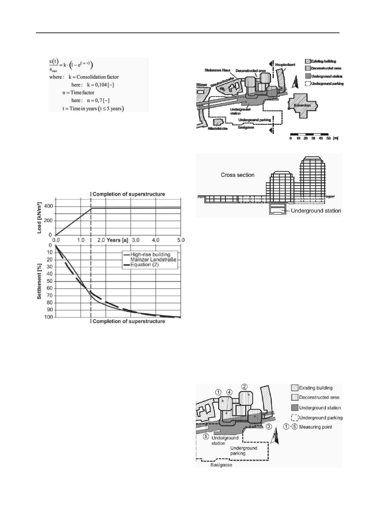
To verify Equation 2 the measured time dependent
settlement behaviour during the construction of the high-rise
building Mainzer Landstraße in Frankfurt am Main is used
(Fig. 6). The construction of the 155 m high-rise building began
in 1973 and the settlements were measured for 5 years. After
this time a settlement of 25.4 cm was measured in the core area
of the high-rise building. At the completion of the
superstructure after 1.5 years the measured settlement was about
70% of the total settlement. The estimation of the time
dependent deformation behaviour can also be described by
Equation 2.
Figure 6. Measured settlement of the high-rise building Mainzer
Landstraße.
3 DECONSTRUCTION OF A HIGH-RISE BUILDING
FOUNDED ON AN UNDERGROUND STATION
In the context of the urban development the city of Frankfurt
am Main plans to redesign the historic centre. Historic façades
and buildings will be reconstructed. To create the necessary
space on the surface an up to 14 storeys high-rise building was
deconstructed. According to the present state of planning the
deconstruction was carried out down to the sublevels.
The high-rise building and its underground parking overlay
2 tunnels and an underground station of the urban metro system.
The loads of the superstructures are directly transferred onto the
tunnels and underground station. Figures 7 and 8 give an
overview on the primary situation prior to the deconstruction.
The sealing of the structures was made of outside layers of
bitumen-based materials. It must be guaranteed that during the
deconstruction of the existing high-rise building and the
construction of the new buildings the sealing of the
underground structures and the sublevels remained intact. For
this purpose especially the uplifts due to the deconstruction and
the deformations of the underground structures and the
sublevels had to be monitored during the execution of the
project according to the observational method.
Figure 7. Overview of the project area.
Figure 8. Cross section of Figure 6.
The soil and groundwater conditions are as follows:
- 0 m to 7 m: quaternary sands and gravel
- 7 m to 30 m: Frankfurt Clay
- below 30 m: Frankfurt Limestone
- groundwater level in a depth of 6 m
The groundwater level is influenced by the river Main which
is 180 m far away. In the course of the geotechnical survey two
aquifers have been encountered. The top aquifer is located in
the non-cohesive soil. The lower confined groundwater layer is
located in the Frankfurt Clay and in the Frankfurt Limestone.
According to the classification of the project into the
Geotechnical Category 3, that is the Category for very difficult
projects in EC 7, an extensive geodetic monitoring program
with 580 measuring points was installed. 220 measuring points
are located around the deconstructed building, 110 are located
in the underground parking and in the sublevels of the
deconstructed building, 30 are in the underground station and
the remaining 220 are located in the tunnels.
The existing buildings were deconstructed down to the
2 sublevels. The uplift that occurred due to the unloaded of the
soil is shown on selected points (Figures 9 and 10).
Figure 9. Selected measuring points.
The selected measuring points 1 to 4 are in the sublevel of
the former high-rise building. Measuring point 5 is at the
transition of the underground station to the tunnel. At the


