572
        
        
          Proceedings of the 18
        
        
          th
        
        
          International Conference on Soil Mechanics and Geotechnical Engineering, Paris 2013
        
        
          2 OVERVIEW OF ENVIRONMENT


              2.1 Study area


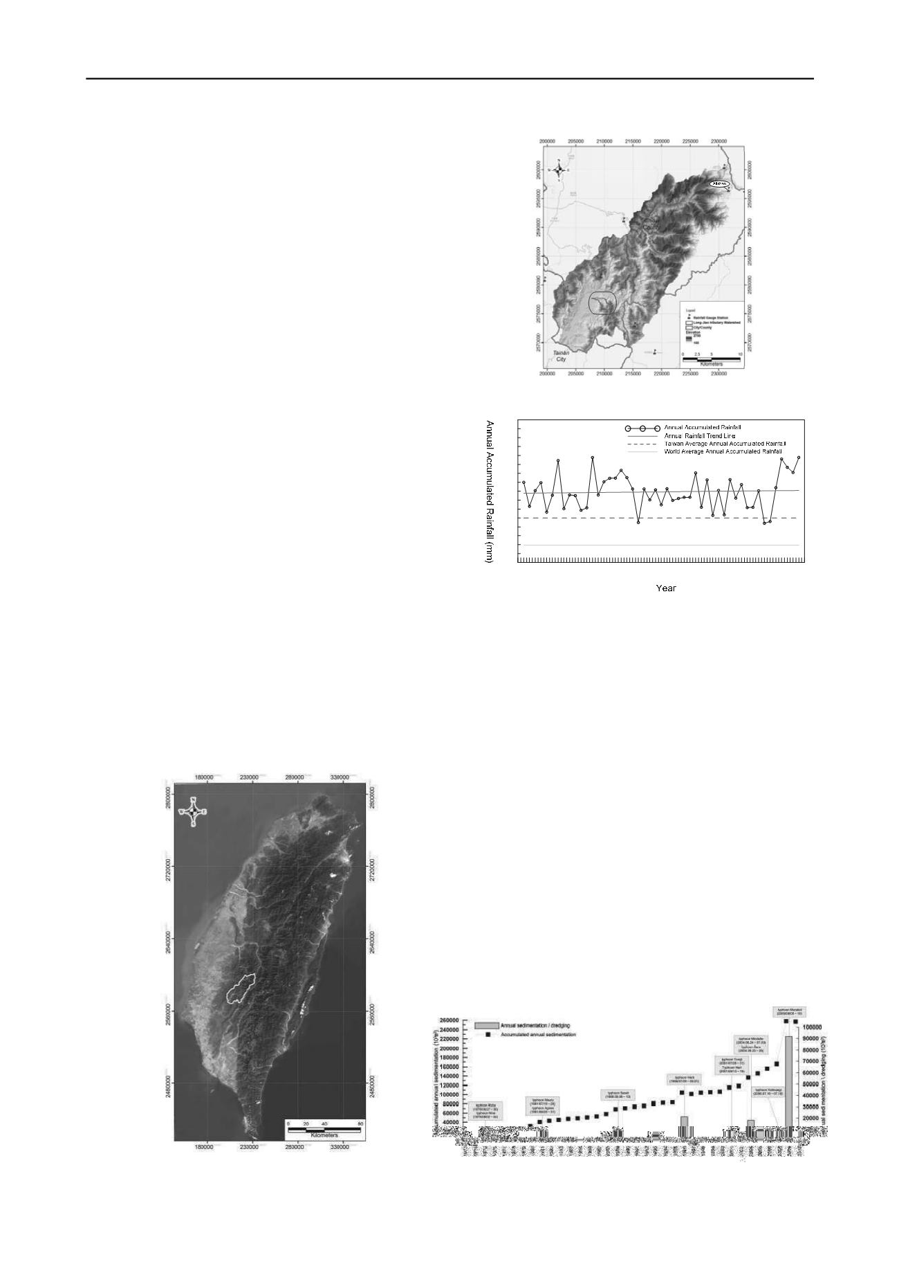
          As illustrated in Figure 1, the Tsengwen reservoir is located in
        
        
          the southwestern portion of Taiwan. It is the most important
        
        
          water resource conservation hydraulic structure and the largest
        
        
          dam in Taiwan. The dam is 400 m in width and 133 m in height,
        
        
          and mainly serves irrigation, municipal water and power supply
        
        
          functions for the southern plains and downstream area of Chiayi
        
        
          county, Tainan and Kaohsiung city shown in Figure 2. The
        
        
          watershed area of Tsengwen Reservoir is approximately 481
        
        
          km
        
        
          2
        
        
          , where Tsengwen river is the trunk river originating from
        
        
          Alishan mountain at elevation of 2,609 m a.s.l. The watershed
        
        
          shape is similar to a quadrilateral with elevations gradually
        
        
          increasing from southwest to northeast, and ranging from 100 m
        
        
          a.s.l and 2,700 m a.s.l. In general, most hill slopes are steeper
        
        
          than 28.8
        
        
          °
        
        
          and approximately represents over 60% of the study
        
        
          area. As for the aspect, slopes are mostly west-facing and
        
        
          southwest-facing in the watershed. There are many fault line
        
        
          and geologic structures and the geological condition of the
        
        
          watershed consists mostly of sandy shale, siltstone, and isolated
        
        
          areas of muddy sandstone, which are prone to more severe
        
        
          weathering and become weak layers in the rock strata. These
        
        
          conditions make the slope unstable during heavy rainfall or
        
        
          strong earthquake shaking. Hence, during the typhoon and flood
        
        
          season, the combination of huge rainfalls and local weak
        
        
          geological conditions easily permit the occurrence of sediment
        
        
          landslides (Lo


            et al


          ., 2012).
        
        
          Due to high topographic relief, annual average temperature
        
        
          ranges from 24
        
        
          ℃
        
        
          in the plains and 11
        
        
          ℃
        
        
          in the mountainous
        
        
          parts of the watershed. According to Alishan rainfall gauge
        
        
          station, average annual accumulated ranges from 1,950 to 4,980
        
        
          ㎜
        
        
          . Recent extreme rainfalls have caused annual accumulated
        
        
          rainfall of Taiwan to increase, especially for Alishan, where,
        
        
          since 2005, annual rainfalls have exceeded 5,000
        
        
          ㎜
        
        
          (see Figure
        
        
          3). This rate is double the annual average precipitation (2,500
        
        
          ㎜
        
        
          ) for Taiwan and over four times of world annual average
        
        
          precipitation. Rainfall distribution increases from the plains to
        
        
          the mountains and is mostly concentrated between May and
        
        
          September when the watershed receives approximately 80% of
        
        
          the overall annual rainfall.
        
        
          Figure 1. Graphical location of Tsengwen reservoir watershed in
        
        
          Taiwan (local coordinate system: TWD97).
        
        
          Figure 2. Topographic map of Tsengwen reservoir watershed (local
        
        
          coordinate system: TWD97).


            1959


            1960


            1961


            1962


            1963


            1964


            1965


            1966


            1967


            1968


            1969


            1970


            1971


            1972


            1973


            1974


            1975


            1976


            1977


            1978


            1979


            1980


            1981


            1982


            1983


            1984


            1985


            1986


            1987


            1988


            1989


            1990


            1991


            1992


            1993


            1994


            1995


            1996


            1997


            1998


            1999


            2000


            2001


            2002


            2003


            2004


            2005


            2006


            2007


            2008


            2009


            0


            1000


            2000


            3000


            4000


            5000


            6000


            7000


            8000


          Gr
        
        
          Figure 3. Time series of annual rainfalls at Alishan gauge station.


              2.2 Relation between reservoir sedimentation and major


              typhoon events


          Presently, the greatest challenge of Tsengwen reservoir is
        
        
          sedimentation. Whether caused by anthropogenic or natural
        
        
          factors, both of them directly triggers problems such as
        
        
          increased turbidity and reduced reservoir storage volume.
        
        
          Figure 4 illustrates the historical trends of sedimentation in
        
        
          Tsengwen reservoir concerning major typhoon events.
        
        
          According to the figure, since completion of reservoir
        
        
          construction, typhoons repeatedly hit the Tsengwen reservoir. It
        
        
          can be found that the peaks in the historical sedimentation curve
        
        
          of Tsengwen reservoir correspond to major typhoon events.
        
        
          Before 2008, the annual average sedimentation volume is
        
        
          4,760,000 m
        
        
          3
        
        
          and still lower than the yearly designed value of
        
        
          5610,000 m
        
        
          3
        
        
          . However, 2009 typhoon Morakot brought around
        
        
          91,080,000 m
        
        
          3
        
        
          of sediment into Tsengwen Reservoir, which
        
        
          occupies about 12% of the reservoir capacity. After the 2009
        
        
          typhoon Morakot, the annual average sedimentation rapidly
        
        
          increases to 7,060,000 m
        
        
          3
        
        
          , exceeding the yearly designed value
        
        
          by 12.6 times. It is truly believed that massive amounts of
        
        
          sediment washed downstream. Also, this event seriously
        
        
          resulted in debris flows and large large-scale landsides along
        
        
          river flanks and close to human inhabitation in upstream areas,
        
        
          and threatens longevity of reservoir and significantly affects
        
        
          water supply to the south area in Taiwan.
        
        
          Figure 4. Historical sedimentation curve of Tsengwen reservoir with the
        
        
          major typhoon events