1304
Proceedings of the 18
th
International Conference on Soil Mechanics and Geotechnical Engineering, Paris 2013
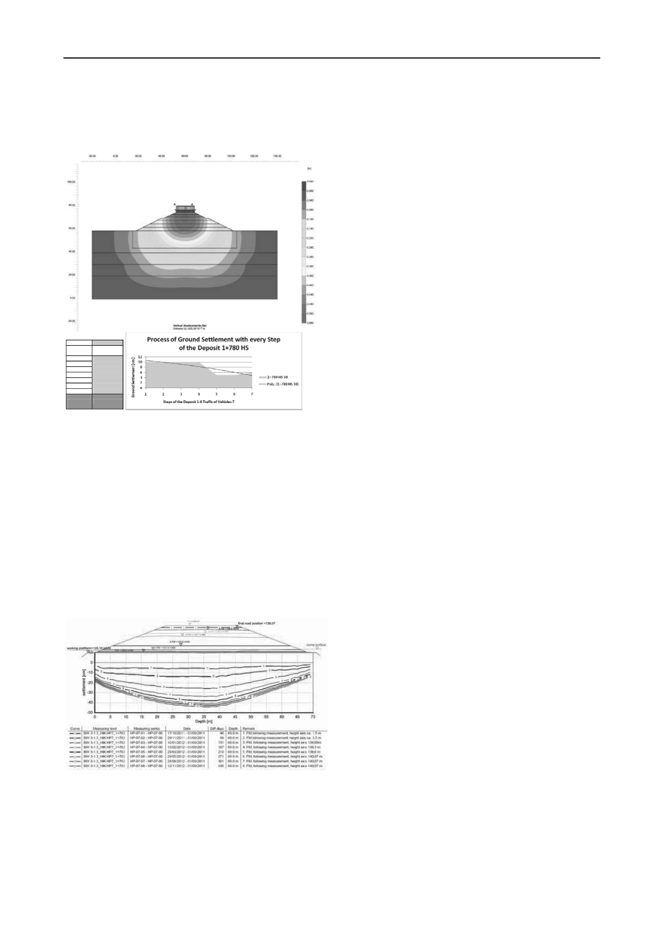
settlements. On the one hand, these settlements decrease with
each load step due to a smaller width of loading and with it
decrease the loads at depth. On the other hand, additional
settlements of the dam itself are calculated for each step.
7 SUMMARY AND CONCLUSION
The construction of roads on mining areas requires close
cooperation between mining engineers, geotechnical engineers
and contractors, as the mining technical characteristics,
requirements in road construction and geotechnical
characteristics must always be brought into line and finished
with high-end quality.
A very comprehensive site investigation is essential in
dealing with man-made fill deposits. The Ménard pressuremeter
brought significant findings throughout the additional
preliminary soil investigation.
A technical and economic optimization was achieved by
adapting the ground improvement methods to the respective
sections. With the help of various ground improvement
methods, settlement reduction and improved stability safety
factors were successfully obtained.
The high quality of the construction with stone columns,
dynamic replacement and CMC was documented not only in
foundation with the usual protocols of the manufacturer, but
also tested regularly during the construction phase by the
Ménard pressuremeter. The settlement calculations and
subsequent field measurements confirmed a significant increase
of quality.
Station
1+780HS 30
Steps of the
Deposit
Ground
Settlement [cm]
1
10
2
10
3
10
4
10
5
5
6
5
Traffic
6
Total
Ground
Settlement
56
8 REFERENCES
Figure 10. Representation of the predicted total settlements of 56 cm
with Plaxis calculation section of 15 m embankment height
Lausitzer und Mitteldeutsche Bergbau – Verwaltungsgesellschaft mbH,
1999, Schlussbericht – Bauen auf Mischbodenkippen des
Braunkohletagebaus im Mitteldeutschen Revier. Senftenberg
Buja,H.-O.,2009, Handbuch der Baugrunderkennung – Geräte und
Verfahren. Wiesbaden
6 RESULTS OF THE MONITORING
Seven horizontal inclinometers were installed below the
embankment across its section and three vertical inclinometers
were also installed at the landfill along the construction road at
the location of the highest embankment. The measurements are
performed during the embankment construction phase to reach a
total height of 15m according to the following sequence:
G.U.B Ingenieur AG, 2010, Ersatz der Bundesstraße B176 zwischen
Pödelwitz und Neukieritzsch, Baugrundgutachte,. Dresden
DIN Deutsches Institut für Normung, 2001, DIN EN 4094-5:
Bohrlochaufweitungsversuche.
Kirstein, J.F.; Chaumeny J.L., 2005, Ein neues Verfahren zur
Bodenverbesserung: CMC (Controlled Modulus Columns) aus
Frankreich. Veröffentlichungen des Instituts für Geotechnik TU
Bergakademie Freiberg, Heft 2005-2, Freiberg
- every 3 m of fill placement
- immediately after reaching the final height and then
every 3 month.
The following figure presents the cross-section measurement
at the location of the design cross section.
Meyer, N.; Emersleben, A.; Kirstein J.F., 2007, Probebelastungen von
CMC-Säulengruppen – Einfluss der Lastverteilungsschichtauf die
Beanspruchung des Untergrundes und der Säulen. Pfahl –
Symposium 2007, Institut für Grundbau und Bodenmechanik, TU
Braunschweig
Vogel, S., 2011, Setzungsprognosen und Monitoring beim Neubau
einer mit unterschiedlichen Bodenverbesserungstechniken auf einer
jungen Kippe gegründeten Bundesstraße. Diplomarbeit, Dresden
ISO/FDIS 22476-4:2009, 2009, Geotechnical investigation and testing –
Field testing – Part 4: Ménard pressuremeter
Chaumeny, J.L.; Hecht, T.; Kirstein, J.F.; Krings,M.; Lutz, B., 2008,
Dynamische Intensivverdichtung (DYNIV®) für die Kreuzung
eines aktiven Erdfallgebietes im Zuge der Bundesautobahn BAB A
71. VERÖFFENTLICHUNGEN des Grundbauinstitutes der
Technischen Universität Berlin, Heft 42, Berlin
EIBS GmbH, 2010, Planfeststellungsunterlage zum Ersatz der
Bundesstraße B 176 zwischen Pödelwitz und Neukieritzsch,
Bauabschnitt 1 (unpublished)
Ahner, C., Kirstein, J., Uhlemann, S., Röder, K., Uhlig, P.:
Baugrundverbesserungsverfahren zur Gründung der Bundesstraße
B 176 auf einer jungen Hochkippe im Braunkohlenrevier der
MIBRAG. Baugrundtagung 2012
Figure 11. measurement results: the settlement curves fit the predictions
in the different earthwork steps of the embankment construction
The measured settlement values in all cross sections were
similar to the predicted settlement and underline the accuracy of
the Ménard pressuremeter and the soil parameters derived from
this test which were used for the finite element using the
hardening soil model.
Ahner, C., Kirstein, J., Uhlemann, S. Uhlig, P.: Ground improvement
methods for establishment of the federal road B 176 on a new
elevated dumb in the brown coal area of MIBRAG, ISSMGE - TC
211 International Symposium on Ground Improvement IS-GI
Brussels 2012


