2150
Proceedings of the 18
th
International Conference on Soil Mechanics and Geotechnical Engineering, Paris 2013
2.2. Weathering Phenomenon
This phenomenon is visible at the rock formation that
are composed by sedimentary rocks( mudstone,
sandstone, conglomerates), which are new deposits with
weak clay cementation. Under the action of the
atmospheric agents they are transformed from weak rock
to soils. When the road passes in cutting in the zone with
clay rocks we will be attention and we will take the
engineering measures to protect the stability of the
environment.
2.3. The movement and sliding of the weathered mass
rocks
From the beginning of the new road we have identified
some zones with limited area landslide. The kind of the
instability are:
Slide of the colluviums
Slide of the upper part of the weathered rocks
Rock landslides
Debris flow
We thing that , the design of this road to show maximal
care for the stability of the slopes during and after the
construction of the road and a special attention must to
paid for the protection of the foundations of the bridges
that are on the slopes prone to slide.
2.4. Activity of the tectonic movements(tectonic faults )
In Albania there are a developed regional tectonics,
which is mainly horizontal with a
,low angle over thrust and others secondary tectonic
movement.[5] The eastern areas have moved with a low
angle over thrust towards west. This phenomenon has
caused a total destruction of the rock mass in 7 km
length of the road, and it is associated with a lot of other
local tectonics. These zones are founded in the contact
between different rocks, or inside the same rock. As
result of this phenomenon in the hills side many rocky
mass have moved toward the relieve fall and have
created a rocky bent relieve. We must be very attention
to not destruct the existing brittle, or frail equilibrium.
2.5Seismic Hazard
After Albanian Seismic Code [4] the zone to be studied
is classify ( by MKS-64) with intensity 8 ball and the
soils in the second category [ ]. For calculation of the
slope stability, by [ 2 ] we can use a
max
= 0,2g, and the
deep of epicentrum 25-30 km. For these conditions
some of the observed slides can to reactivate caused the
destruction of the road.
3. GEOLOGY AND HYDROGEOLOGY
The geological structure of the studied area[1] is
composed by sedimentary deposits, limestone rocks,
and granular rocks as below:
3.1 Limestone rock
(Pg
2
, Cr
2
, Cr
1
, J
1
, J
2-3
up T
3
).
They have white to grey color, little cracks, in some part
karst phenomenon, very resistible against atmospheric
agents, very good characteristics for the foundations of
the bridges, stabilized slopes and for the embankment.
3.2 Paleogene’s deposits
(Pg
1
, Pg
3
I
).
They are flysch deposits, brown to beige color, medium
to weak cementation, in superficial part weathered, they
form unstable slopes and at Radhima is very active
sliding zone.
3.3. Neogene’s deposits
( N
I
2h
, N
I
2t
, N
I
3
).
They are composed by mudstone, sandstone and rare
conglomerates, conglobreccias, brown to beige color,
good to weak cementation with superficial part
weathered. In the mudstone layer and colluviums
drposits can observed landslide.
3.4. Quaternary deposits
( Q
4
),
Are alluvial, torrent and colluviums deposits. Alluviums
of the Dukati and Shushica rivers are consolidated
gravel, sands, silty- sands, silty- clay, with 20-25m
thickness. Elluviums or torrent deposits are moderate
consolidate silty- clay, silty- sands with 8-15 m
thickness. Colluviums are presented by silty- clays and
gravely-silty-clays, moderate consolidated, unstable and
with 2-4,5m thickness.
The level of the underground water is deep and the water
is not aggressive to concrete and steel.
4. FIELD AND LABORATORY INVESTIGATIONS
For the part of the road that passes in cutting or over
embankments, we have made trial pits which passes by
viaducts and bridges, we have made bore-holes until 10-
40m depth. At the same time we have realized SPT-tests
and laboratory tests in ALTEA laboratory from samples
taken by BH. From laboratory test[1] we have
determined physical and mechanical properties for the
soils, some characteristics for the rocks, and LA,
soundnes, Proctor, CBR etc for the disturbed soils and
rocks which will be serve as building material for the
road and embankment.
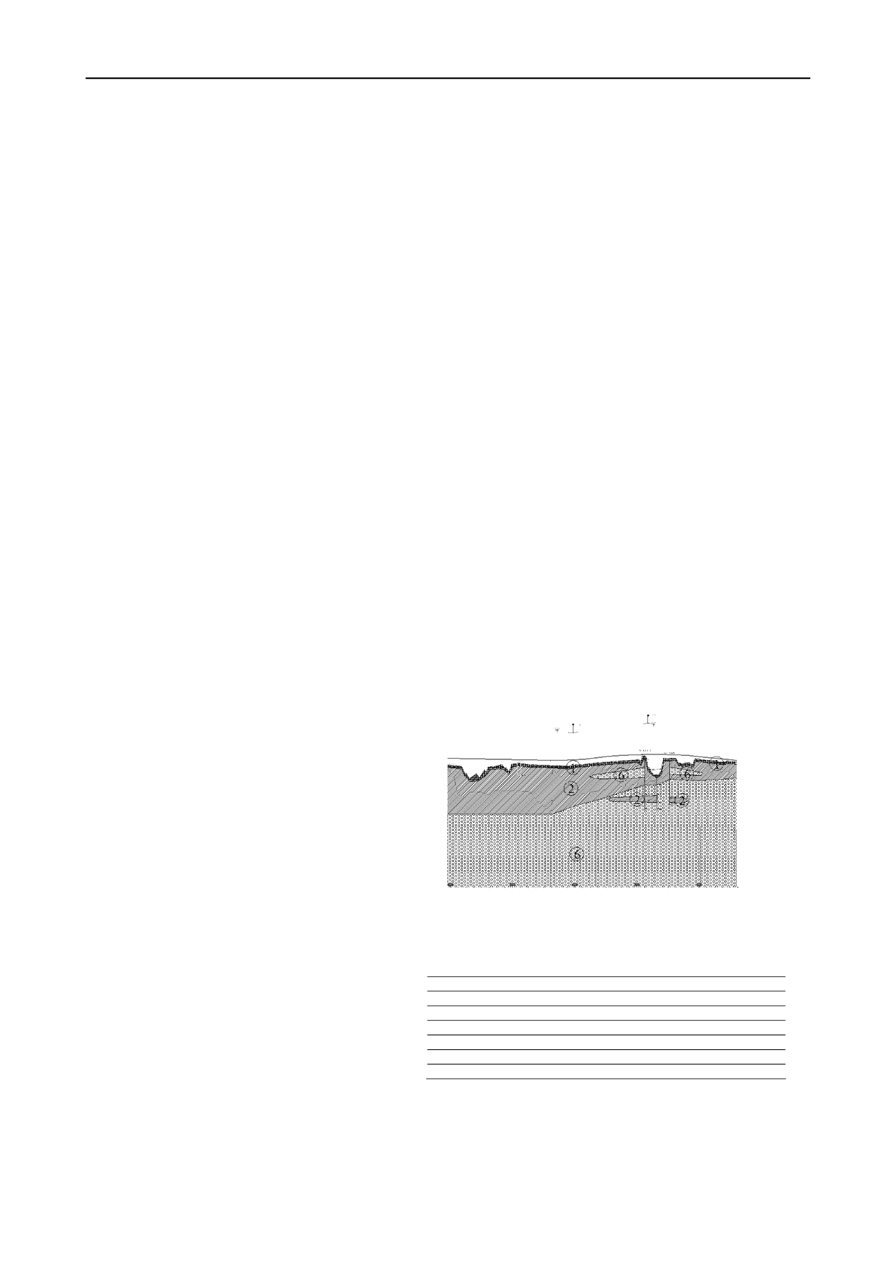
4.1. Results of the site investigations
.
From BH we have discover some different layers and we
have compile the geological profile.
Fig. 1 Geological Profile
4.1.1
By description of layers and SPT-tests we have evidence
six layers (Table 1)
Table 1.
Description of the different layers
Nr.of layer Description Thickness(m) Classification N
SP
1 soft brown silty-clay 3-4 CL 9-12
2 medium dense silty-clay-gravel 3,5-4 GC 24-28
3 clayey’s elluvium 6-8 ML-CL 60-80
4 sand’s elluvium 4-6 SM 50-60
5 gravel and sandy-silty-gravel 7-14 GM 35-50
6 moderately weak mudstone 7-30 - 80-12 and sandston
4.2. Results of laboratory investigations
From laboratory tests we have determined the following
parameters :
Grain size distribution


