2142
Proceedings of the 18
th
International Conference on Soil Mechanics and Geotechnical Engineering, Paris 2013
was initiated. Nonetheless, a loss of road base during the
monsoon season the next year imposed a stop on the work. The
remedial plan was revised and implemented, but failed again
due to typhoons in 2005. The current repair works have been
completed and generally show no major signs of slope distress.
However, data from subsurface exploration and in-situ
monitoring have shown signs of slope instability.
Figure 8 indicates potential slip surfaces in the upslope that
would have impact on the road section. The downhill side slope
also was not improved during the remedial works and its surface
was bared with remains of previous slides. The upslope
mitigation works are not useful for the stability of the
downslope area and do not remove the concerns regarding the
long-term stability of the road section and slopes at the site.
Discussion addresses the potential for further remedial works,
but it is pointed out that the cost of these may make a rerouting
of the road desirable in the long term.
Mt. Ali Road 39Km
Section C‐C’
Elev.
(m)
SandyGravel
SiltyGravel
SiltySand
Sandstone
Sandstone/Shale
PotentialSlipSurface
Groundwater Level
Figure 8. Chang and Huang. Instabilities detected by borehole
investigation
Long and Tjok
present a paper on submarine slope instability
due to earthquake excitation leading to mass gravity flow which
may pose risk for the integrity of offshore structures along the
flow path. This paper demonstrates the ability of using a fully
coupled nonlinear effective stress analysis to simulate the
development of liquefaction and the instability of a liquefied
slope. A prediction of run-out distance of subsequent debris
flows is also made. The authors use a 1D model and parameters
correlated with liquidity index in the absence of other data,
although they also point out that estimation of run-out distance
should be tested and calibrated to the case in question.
Quan Luna et al.
present a study on the effects of
earthquakes on subsequent slope stability, undertaken in an
explicitly multi-hazard framework. The developed model is
designed to give a rough spatial and temporal prediction of
expected change in landslide hazard in an area following an
earthquake. The model is able to describe the reduced impact of
earthquakes with distance from the epicenter as well as how the
soil looses strength due to shaking and gradually regains it with
time. These reductions are then applied to an equilibrium
stability analysis in order to compute new factors of safety on
stability. The model is demonstrated by using a virtual region,
and while further work is required to calibrate and validate the
model with respect to real situations, it provides a mechanism
whereby prospective outcomes from future hazards can be
investigated in a conceptual manner.
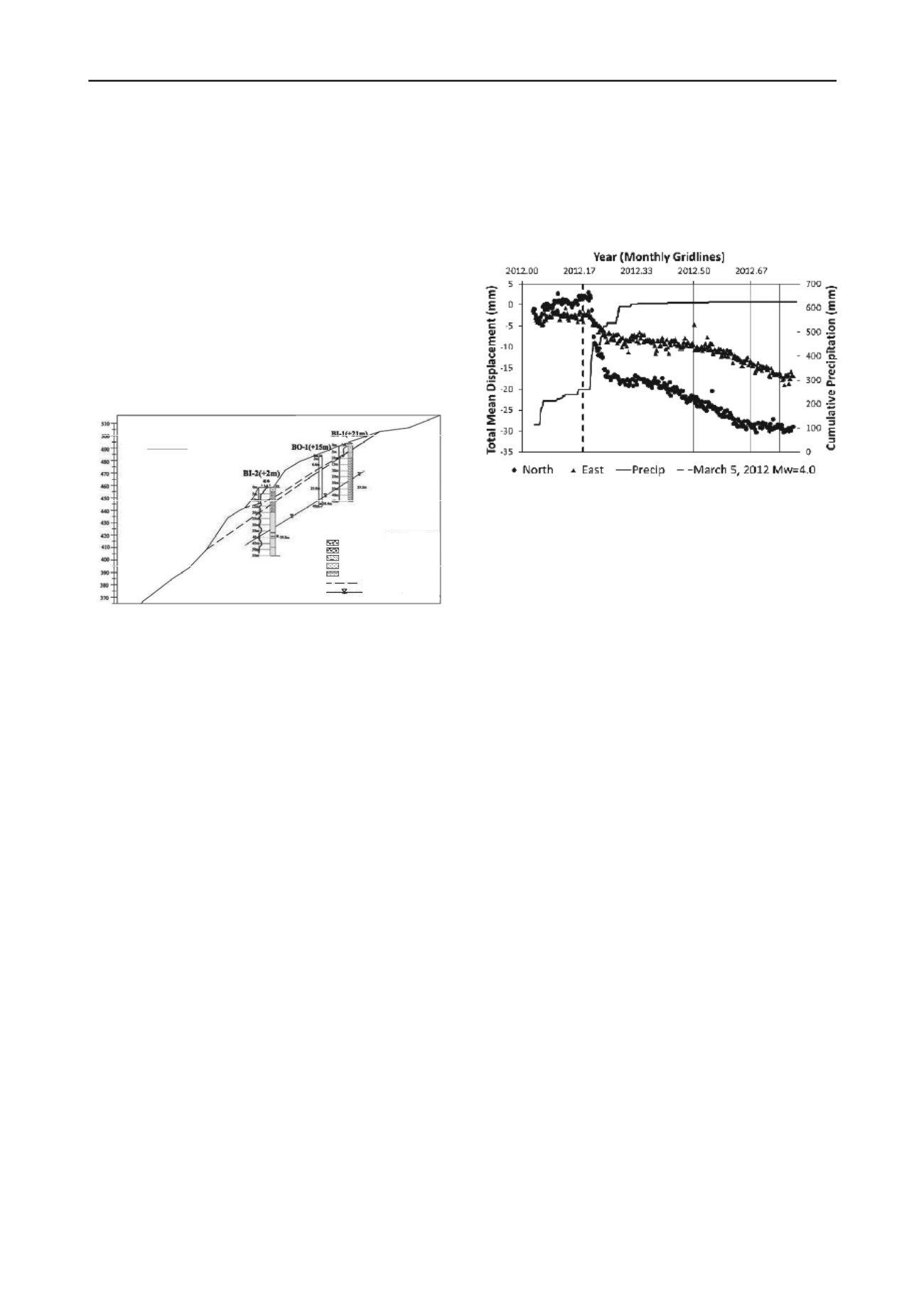
Cohen-Waeber et al
. presents data from a project combining
GPS and InSAR time series analyses for the detailed
characterization of spatial and temporal landslide deformation
as a result of static and dynamic forces. A review of three
independent InSAR time series analyses of the Berkeley Hills
from 1992-2011 shows remarkable consistency. They reveal
accelerated landslide surface deformation as a consequence of
precipitation, though not in relation to seismic activity. Further,
after a mild wet season in early 2012, the GPS instrumentation
of several landslides in the Berkeley Hills has recorded well-
defined precipitation triggered slope movement. In contrast, the
occurrence of a nearby Mw = 4 earthquake did not appear to
have produced a measurable effect (Figure 9). Both InSAR and
GPS studies confirm strong correlation and sensitivity to
periods of precipitation, and downslope sliding velocities of
around 30 mm/year. These observations, taken over longer time
periods will enable important insight on the triggering
mechanisms and internal landslide behavior of this area.
Figure 9. Cohen-Waeber et al. North (circles) and east (triangles)
components of relative displacement with respect to reference site P224
shown together with cumulative precipitation (solid line) and time of
Mw = 4 earthquake (dashed line).
6 PROGRESSIVE FAILURE OF SLOPES
Two contrasting papers on progressive failure are included – the
first presents retrogressive failures in tuff over an existing
landslide area, and the second investigates the strain softening
behavior of sensitive clays leading to river bank erosion.
Şengör et al.
present a paper on a landslide that occurred
during foundation excavation of an industrial plant in Turkey.
The instability occurred in a natural slope with a slope angle of
9
°
-13
°
. The sliding mass grew progressively backward into the
slope as multistage rupture surfaces from the toe of the landslide
developed. Back-analyses and laboratory tests were performed
for the determination of shear strength parameters at the sliding
surface. Mitigation measures included: two rows of stabilizing
piles which were analyzed by FE independently for
geotechnical and structural performance, permanent ground
anchors, and surface drainage. The deformations of the system
were measured by 12 inclinometers (8 in the soil, 4 in the piles)
at each stage of the construction works and there have been no
displacements in three years since completion.
Dey et al
. present a study on upward progressive failure due
to river bank erosion in sensitive Canadian clay which is
numerically modeled using nonlinear post-peak strain softening
behavior. Three cases are analyzed. In Case-I, the ground
surface is horizontal and there is a 15m thick layer of sensitive
clay below a 5m crust. The Case-II is same as Case-I but the
ground surface is inclined upward at 4
°
. In Case-III only a 1.0 m
thick sensitive clay layer parallel to the horizontal ground
surface from the toe of the slope is assumed, with the crust the
same as for Case I.. In Cases I and II global failure was found to
occur. However, for Case-III, although global failure did not
occur, the shear band propagation reduced the shear strength in
the potential failure plane significantly over a large distance and
the slope might be marginally stable for further loading. Hence
it is shown that the pattern of propagation of shear band varies
with soil type and slope geometry.
7 UNCLASSIFIED
This last group of papers includes some highly theoretical
contributions and some highly pragmatic ones – both ends of
which help to advance the state of knowledge or practice within
the profession.


