2140
Proceedings of the 18
th
International Conference on Soil Mechanics and Geotechnical Engineering, Paris 2013
permeability zone, leading to elevated pore pressures in that
zone during heavy rainfall. The upper slope failure then resulted
in an additional surcharge loading and failure in the lower slide
mass. This paper highlights the importance of local geological
conditions on the triggering of slope instability and that
localized heterogeneity can play a major role in the distribution
of groundwater flow.
Figure 5. Coutinho and da Silva. Upper and lower slope failure models.
Son et al.
present a study on landslide susceptibility zonation
for an area in the south central coast of Vietnam developed
using a Bayesian conditional probability model. Surveyed
landslides from one year’s rainy season were used as inputs to
the model which was examined to develop suitable weighting
factors on elements such as elevation, slope angle, drainage
distance, geology etc. and was integrated with GIS analytical
tools to produce the map. The reliability of the model can be
improved as new landslide occurrences are updated annually in
the landslide inventory.
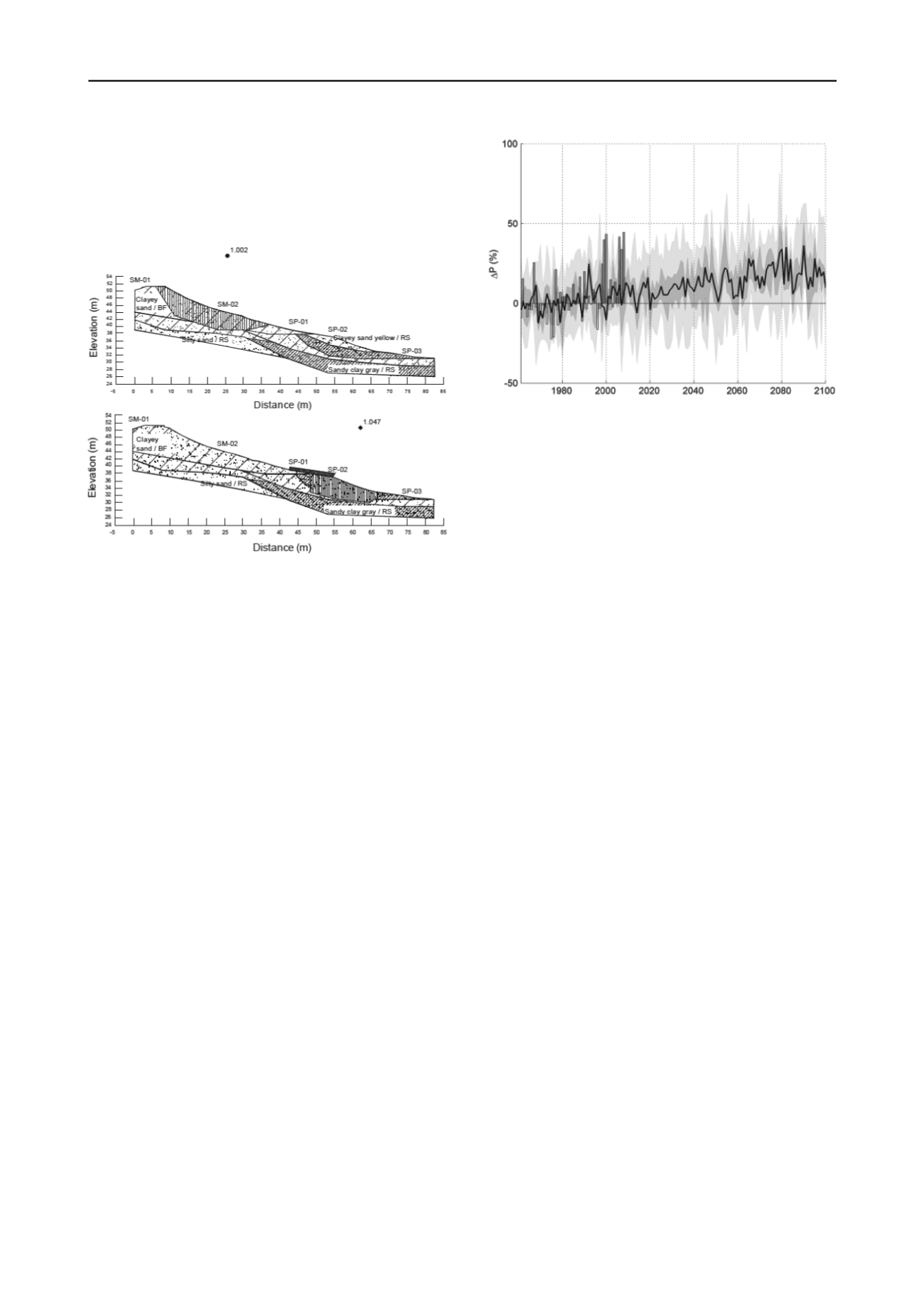
Tremblay et al.
discuss the influence of climate change on
the risk of landslides and its assessment for a valley in Sweden.
Notable effects of climate change are increases in annual
precipitation and temperature and potential reduction in water
levels in the river through dry summer periods (although
controlled by the authorities) and increased river flows in winter
(Figure 6). Each of these scenarios may lead to a decrease in
slope stability around the river valley. Readers are referred to
detailed risk assessment and reports available from SGI.
Li et al.
discusses the detailed instrumentation and full-scale
field monitoring programme for a study on the mechanisms of
rainfall-induced sliding slope, through a study conducted for a
new development in Hainan, China. Large variations of
volumetric water content and matric suction at shallow depth in
decomposed granitic soils, during the rainy season, may explain
why so many slope failures have occurred in this region at times
of heavy rainstorm activity. The paper also highlights the
inherent difficulties associated with the protection of delicate
monitoring instruments on an active construction site.
Harris et al.
describes the implementation of an early
warning system (EWS) for a highway embankment subject to
rainfall induced landsliding. Volumetric water content sensors
were installed at a cross section of the site. A 2D finite element
model was then used to replicate the response of the sensors to
rainfall, using monitored rainfall events as an input. Next, a
limit equilibrium analysis was carried out and an artificial
neural network was trained to predict the factor of safety
obtained using the sensor readings as inputs. Data from rainfall
forecasts are then used to establish a predicted factor of safety
for the slope in real time, allowing road-users to be advised
accordingly.
Figure 6. Tremblay et al. Percentage increase in precipitation with year
from 16 climate scenarios after Bergstrom et al. (2011)
3 DEBRIS FLOWS AND FLOW SLIDES
In total 10 papers are presented on debris flow or flow slide
initiation, and aspects of runout or travel distance if the
specifics of entrainment of debris along the path of movement
as taken into account (see Fannin and Bowman, 2010)
Several studies are presented that use statistical data to
derive debris flow hazard potential in particular areas based on
local topography and associated hydro-geological behavior.
Some of these studies follow statistical-empirical
methodologies that do not require precipitation inputs, and may
be used for a general assessment of debris flow potential, while
other studies include a temporal element by taking account of
precipitation records.
Yune et al.
present a paper on debris flows
that occurred in the Umyeon Mountain area of Seoul, Korea
during the rainy season of 2011, determining that most were
initiated from small slope failures induced by high-intensity
rainfall. The paper discusses the application of a statistical
landslide hazard map which has been developed on parameters
such as slope angle and direction, strength of soil, hazard
record, rainfall condition and plantation type. This map has
demonstrated the ability to highlight areas that are vulnerable to
heavy-rainfall-induced slope failure and resulting debris flow
disasters.
Lin and Lin
present a study on the analysis of debris flow
torrents in Nantou County, Taiwan, using discriminant analysis
based on 199 known debris flow torrents and 175 non-debris
flow torrents. The influence factors included: watershed area,
stream length, form factor, hypsometric integral, stream mean
slope, slope distribution, slope aspect, and geological formation.
In order to examine the feasibility of the model, the data sets of
debris flow torrents and non-debris flow torrents not used in
developing the estimation models were used for validation and
prediction.
Cepeda et al.
presents a probabilistic procedure based on a
Monte Carlo simulation for run-out modeling of debris flows, in
order to analyse the effect of uncertainties in the input
parameters. The framework is based on a dynamic model,
which is combined with an explicit representation of the
different parameter uncertainties. The main goal is to present a
framework to obtain potentially expected run-outs and
intensities in areas where it is not possible to determine the
rheological parameters on the basis of back analyses.
Two papers are presented that use experimental techniques
to examine debris flow behavior.
Katzenbach and Bergmann
present a paper to understand some fundamental flow properties
of saturated soil in a large-scale experimental apparatus. The
study is designed to examine the influence of parameters such
as grain size, grain shape and grain size distribution, water
content and pressures on the flow behaviour. This paper focuses
on coarse grained water-saturated soils, which excludes the


