1497
Technical Committee 203 /
Comité technique 203
Proceedings of the 18
th
International Conference on Soil Mechanics and Geotechnical Engineering, Paris 2013
this study can be used for development of mapping spectra
response on the bedrock (site class B).
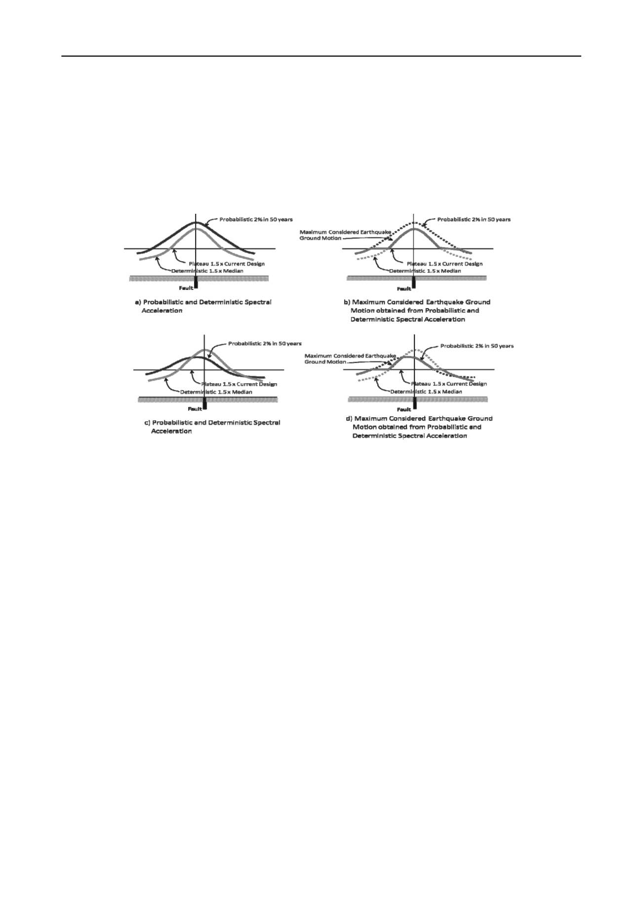
4. COMBINING DETERMINISTIC AND PROBABILISTIC
CONTOURS.
The map used in the design is obtained by combining
deterministic and probabilistic maps prepared by Team for
Revision of Seismic Hazard Maps of Indonesia 2010. The
approach is based on Leyendecker et al. (1995) and The
National Earthquake Hazards Reduction Program (NEHRP)
2003 in Commentary Appendix B. The procedure for obtaining
maximum considered earthquake ground motion is illustrated in
Figure 2.
Figure 2.
The procedure for combining deterministic and probabilistic contours to obtaining maximum considered earthquake ground
motion (NEHRP 2003, Commentary Appendix B)
5.
RESULTS AND DISCUSSION
The model for estimation of Maximum Considered Earthquake
Geometric Mean (MCE
G
) PGA has been developed based on
available data, studies, and literature. Seismotectonic setting
was evaluated in order to develop a seismic source model for
input to SHA. The model includes parameters for the
background, fault, and subduction sources. Relative distribution
of magnitude for each source was modeled using truncated
exponential model and pure characteristic model. Several
attenuation functions including NGA were selected in order to
consider the type of rupture mechanism as well as the regional
geology. In order to account for epistemic uncertainties, the
logic-tree was implemented. Maps of probabilistic and
deterministic from fault and Subduction sources PGA are
shown in
Figure 3
to
Figure 5
. Maps of MCE
G
obtain from
combining probabilistic and deterministic contours are shown in
Figure 6
.
6. REFERENCES
Asrurifak M., Irsyam M., Budiono B., Triyoso W., and
Hendriyawan., (2010),
Development of Spectral Hazard
Map for Indonesia with a Return Period of 2500 Years
using Probabilistic Method,
J. Civil Engineering
Dimension, Vol. 12, No. 1, March 2010, 52-62 ISSN 1410-
9530 print / ISSN 1979-570X online.
Cornell, C.A., (1968),
Engineering Seismic Risk Analysis
,
Bulletin of the Seismological Society of America, Vol. 58.
Frankel, A., (1995),
Mapping seismic hazard in the central and
eastern United States
, Seismological Research Letters, v.
66, n.4 p. 8-21.
Harmsen, S., (2007),
USGS Software for Probabilistic Seismic
Hazard Analysis (PSHA)
, Draft Document, (unpublished).
Irsyam, M., Asrurifak M., Hendriyawan, B Budiono, Triyoso
W., and Anita Firmanti, (2010),
Development of Spectral
Hazard Maps for Proposed Revision of Indonesia Seismic
Building Code
, Geomechanic and Geoengineering an
International Journal, Vol. 5. No. 1, 35-47, DOI:
10.1080/17486020903452725.
Irsyam M., Asrurifak M., Hendriyawan, Budiono B., Triyoso
W., Hutapea B., (2008),
Usulan Revisi Peta Seismic Hazard
Indonesia Dengan Menggunakan Metode Probabilitas Dan
Model Sumber Gempa Tiga Dimensi
, Prosiding Seminar
HATTI, 18-19 Nopember 2008, ISBN 978-979-96668-6-4.
International Code Council, Inc., (2009),
Internasional Building
Code
.
Kramer, S.L., (1996),
Geotechnical Earthquake Engineering
,
Prentice-Hall Inc., Upper Suddle River, New Jersey
Leyendecker, E. V., D. M. Perkins, S. T. Algermissen, P. C.
Thenhaus, and S. L. Hanson. 1995.
USGS Spectral
Response Maps and Their Relationship with Seismic Design
Forces in Building Codes
, U.S. Geological Survey, Open-
File Report 95-596.
McGuire, R.K. (1995),
Probabilistic Seismic Hazard Analysis
and Design
Earthquakes
: Closing the Loop
, Bulletin of the
Seismological Society of America, Vol. 85, No. 5, pp. 1275-
1284, October.
The NEHRP (National Earthquake Hazards Reduction Program)
Recommended Provisions for Seismic Regulations for New
Buildings, 2003 Edition, Commentary Appendix B.
Tim Revisi Peta Gempa Indonesia, (2010a),
Ringkasan Hasil
Studi Tim Revisi Peta Gempa Indonesia 2010
, Bandung I
Juli 2010, Laporan Studi.


