2408
Proceedings of the 18
th
International Conference on Soil Mechanics and Geotechnical Engineering, Paris 2013
80 m hub height and triple bladed rotors with a 93 m diameter.
The tower has a typical tapered tubular steel design and is
founded on a 16 m diameter hexagonal reinforced concrete
shallow foundation at 3.6 m depth. The site is underlain by
carbonate-rich clayey silt tills that are a ubiquitous feature of the
Great Lakes basins and is located at the confluence of four
major geological deposits. These consist of the Port Stanley and
Tavistock tills, glaciolacustrine sand and gravel, and
glaciolacustrine clayey silt
.
These materials were laid down in
the Port Bruce Stade (c. 14,800 years bp.) during the re-advance
of the Laurentide Ice Sheet of the Late Wisconsin. These
subglacial lodgement tills are calcareous and fine-grained,
suggesting that the ice overrode and incorporated fine-grained
glaciolacustrine sediments deposited during the previous Erie
Interstade. This has created approximately 40-45 m thickness of
clayey silt tills with interbedded glaciolacustrine sediments. The
bedrock is shale with limestone-dolostone-shale interlayers.
2.2
Overview of site investigation
The site investigation was designed to establish detailed
stratigraphic and geotechnical characteristics for the soils
beneath the wind turbine foundation. Forty metre deep
boreholes were drilled on the site to evaluate the soil profile,
perform
in situ
tests and collect high-quality samples for
laboratory testing. A track-mounted drill was used for the
drilling activities. Three boreholes were drilled 10-16 m
adjacent to the turbine foundation (to ensure minimal stress
change from the foundation). The wash boring method was used
for two of the holes and the PQ coring method for the other
hole. The boreholes were drilled to depths of twice the
foundation diameter and were spaced at 3 m to allow for later
cross-hole geophysical testing. Thin-wall shelby tube sampling
was completed to obtain minimally disturbed samples for the
laboratory testing.
In situ
testing adjacent/in to the boreholes
consisted of SPT, field shear vane, cross-hole geophysics and
seismic SCPTu, and was conducted to depths of 30 m. To
complement the
in situ
test results, laboratory tests were
conducted for soil classification and geotechnical properties.
2.3
Soil description and basic properties
This deposit can be separated into three zones: a heavily
weathered oxidized upper crust from 0
–
1.5 m, a partially
weathered lower crust that transitions from an oxidized to an
unoxidized state from 1.5
–
4.5 m and an unweathered clay till
below 4.5 m to greater than 40 m depth. The intensity of
fissuring in the upper crust is very intense and the deposit
becomes nearly unfissured below 4.5 m. The fissures are
vertically dipping planar joints striking at right-angles. The
fissure spacing at 1.5 m depth is 15 cm and this increases to 0.6-
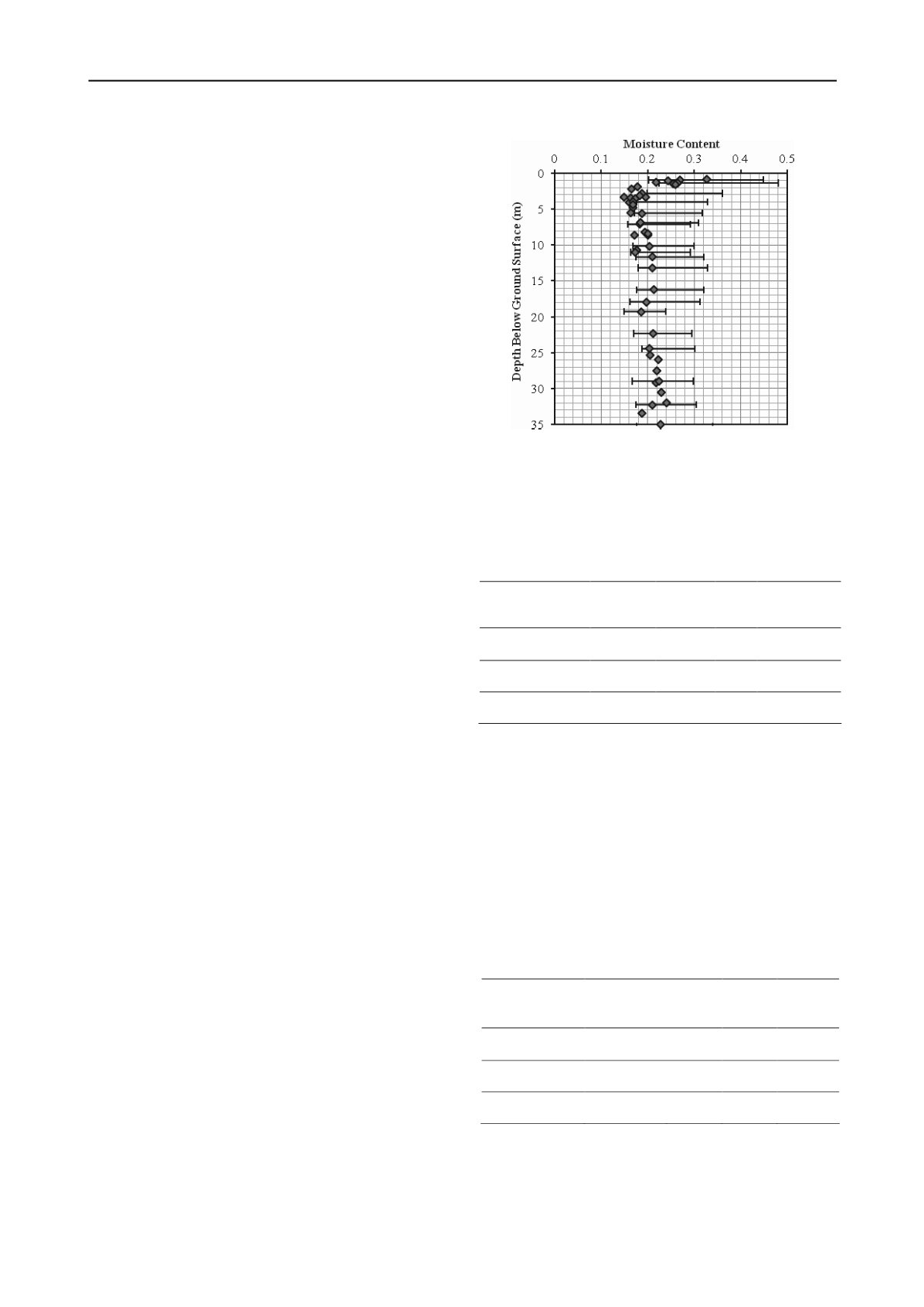
1.2 m at 4.5 m depth. The variation in moisture contents and the
Atterberg limits with depth are shown in Figure 1.
The upper crust zone of this deposit is weathered, mottled
brown-grey or brown-green with a stiff to very stiff consistency.
This weathered zone generally has higher moisture contents
(22-32%) due to the infiltration of surface water into the fissures
of the clay. The underlying lower crust is prevalently brown in
colour and has a very stiff consistency and relatively lower
natural moisture content (16-20%). At several locations this
layer has clayey silt, sandy clay and silt seams. A soil colour
change occurs from brown to grey between 3 and 4 m below the
ground surface. Below the crust, the unweathered till extends
beyond the maximum depth of sampling. This zone is
characterized by a uniform grey appearance, a stiff to very stiff
consistency and relatively uniform moisture contents (16-24%).
Atterberg test results (Table 1) indicate that the material can
be classified as CL-ML to CL (silty clay or low plasticity clay).
There is an increase in liquid limit and plasticity towards the
upper crust and the clay content is also found to increase near
the surface, leading to little change in activity (0.5).
Figure 1. Moisture contents and Atterberg limits with depth.
The liquidity index (I
L
) is found to range from 0.2 to 0.4 in the
virgin till, is
below
zero in the lower crust and ranges from 0.15
to 0.25 in the upper crust. The bulk unit weights of the profile
are generally uniform and range from 20.3 to 21.6 kN/m
3
.
Table 1. Atterberg Limits and Particle Size Distributions.
Layer
Liquid
Limit (%)
Plastic
Limit (%)
Clay
(%)
Silt
(%)
Sand
(%)
Upper Crust
46
21
40 45 15
Lower Crust
34
19
29 49 20
Unweathered Till
30
17
31 45 21
Semi-quantitative XRD shows that the unweathered till is
predominantly composed of quartz/feldspar (39%), carbonate
(25-35%), mica/illite (16%), chlorite/kaolinite (7%) and trace
minerals. In the 2 micron range the minerals are dominated by
illite, calcite and chlorite. The lower crust has a similar
composition, with more quartz/feldspar (49%), lower carbonate
(22%), mica/illite (18%), chlorite/kaolinite (7%) and swelling
clay (2%) and other trace minerals. In similar deposits (Quigley
and Obunbadejo, 1974) downwards leaching has removed
carbonates from the near surface and redeposited lower in the
crust. Table 2 shows the values of total carbonates, dolmite and
calcite (from the gas evolution method) in the three zones,
confirming the removal of carbonates from the near surface.
Table 2. Carbonate Contents in the Soil Profile.
Layer
Total
Carbonates (%)
Dolomite
(%)
Calcite
(%)
C/D ratio
Upper Crust
0
0
0
-
Lower Crust
19.9
6.2
13.7
2.2
Unweathered Till
24.8
6.2
18.6
3.0
2.4
Compressibility and strength properties
In common with other tills around the world the
compressibility, permeability and strength characteristics of this
material are generally a function of the clay content. Estimates
of undrained shear strength (s
u
) using various methods are


