79
Honour Lectures /
Conférences honorifiques
Proceedings of the 18
th
International Conference on Soil Mechanics and Geotechnical Engineering, Paris 2013
g)
h)
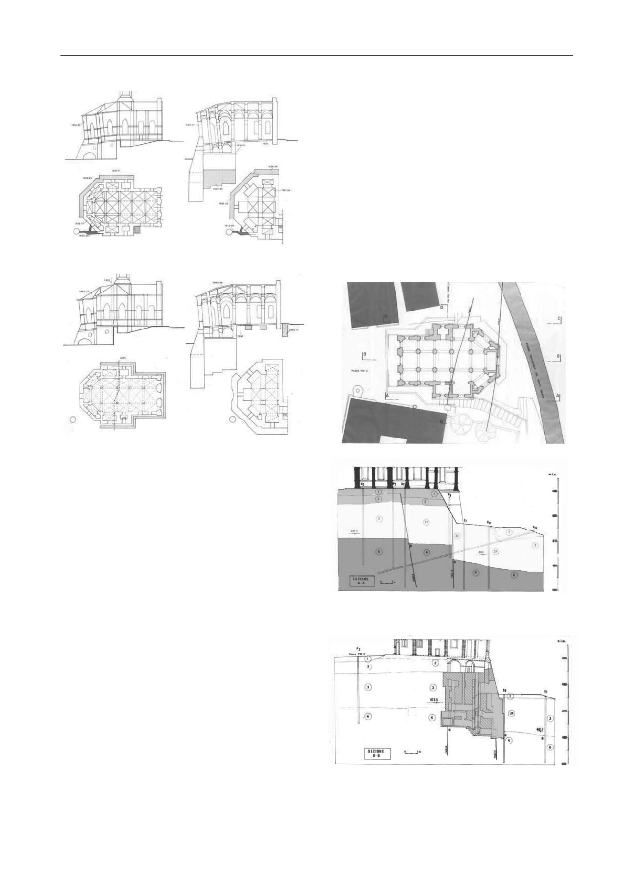
Figure 18. Main events in the Pienza Cathedral history: a) 1462;
b) 1503-1508; c) 1514-1545; d) 1570-179e) 1888-1895; f) 1908-1920;
g) 1922 -1933; h) 1955 - 1979 (Di Pasquale 1992).
The phenomenon has always been attributed to the poor
quality of the foundation soil, to its many fissures and to the
effects of underground water. The sole exception is a report on
instability dated 1604, in which an architect, A. Sandrini,
having noticed that the earth surface fissures caused by the 1545
displacements were aligned with the scarp and extended
throughout the whole southern side of the village, stated that the
apse settlement was due to the movement of the slope; this
interpretation of the phenomenon has been systematically
ignored.
In about 1750, as the instability in the area of the apse
continued, suggestions were made to demolish that part and
restrict the Cathedral to the part rising on the uphill part of the
scarp. Luckily the proposal was not followed up and further
measures were taken to consolidate the walls and foundations of
the apse.
In 1911, as concerns grew for the stability of the Cathedral, a
lively debate occurred between those who suggested
underpinning the apse and those who, following the example of
what had just be done for the Spina Church in Pisa, suggested
dismantling the apse to build a new foundation. In any case
everyone was persuaded that the settlement of the apse was due
to the poor quality of the foundation soil. Luckily the first
position prevailed and between 1911 and 1929, by means of
sample excavations through the sandstones to the underlying
marly clays, stone and brick pillars were built under the apse
down to more than 20 m from ground level downhill from the
scarp. It was deemed that the apse, provided with a rigid
monolithic foundation resting on the layer of marly clays, was
finally consolidated. However, cracks causing detachment of
the apse from the nave occurred again quite soon and in 1956 a
new study committee was appointed including a geologist
engineer who identified two traces of a vicarious fault,
practically aligned with the cracks in the walls, having a total
throw of about 15 m. Quite surprisingly the new structural
consolidation measures adopted a few years later did not take
this fact into any account.
Later, between 1979 and 1984 a more thorough survey was
made of the structures and of the relevant instability and
geological and geotechnical investigations were carried out to
define the bedding and mechanical characteristics of the
foundation soils.
The following figures (Figs. 19, 20) show two stratigraphic
sections and their positions in the plan view. Under the square
and the nave of the Cathedral a limestone layer 3 to 4 m thick
over-laps the weakly cemented sand and fissured sandstone
layer, having a thickness of 12-15 metres, which can be seen in
the scarp on the sides of the apse (Lazzarotto and Micheluccini
1986, Calabresi et al. 1988, Calabresi et al. 1998).
a)
b)
Figure 19. a) The Cathedral plan and the traces of the fault traces; b)
Geologic section AA, parallel to the church axis;
Figure 20. The axial section BB shows the position of the foundation
block relative to the fault planes.


