2502
Proceedings of the 18
th
International Conference on Soil Mechanics and Geotechnical Engineering, Paris 2013
3 sUB-soil characterisctics
a total of 67 exploratory boreholes were drilled in the area to
gather information about sub-soil type and characteristics. the
borehole locations were carefully decided to make them
distributed over the entire area as well as to cover zones of
different land use (i.e. pond, road, houses etc.). the borehole
that are referred here are marked by grid points as shown in
figure 1. the boreholes, approximately 100 mm in diameter,
were drilled using water flush aided by chiselling. twelve
boreholes were of 30.5 m depth and the rest were of 15.0 m
depth below the existing ground level. standard penetration
tests (spt). were made at 1.5 m interval. Undisturbed samples
were retrieved from cohesive layers by pushing conventional 76
mm external diameter thin-walled shelby tubes. disturbed
samples were also collected from the spt spoon (conventional
split spoon) from cohesive and cohesionless soil layers at
different depths for visual-manual identification of the layers as
well as for laboratory testing.
in general, the sub-soil at the site is found to consist of a
layer of ‘soft to medium stiff silty clay’ extending from the
ground surface to about 4 to 6 m depth. this layer is underlain
by a 10 m thick ‘loose to medium dense fine sand/silt’ layer. A
‘clayey silt’ layer is encounte
red below the fine sand/silt layer
which extend beyond the maximum depth of investigation (i.e.,
about 30 m from surface). thus, up to a depth of 30 m the sub-
soil at the site is idealized to have three distinct layers (top silty
clay layer, intermediate fine sand/silt layer and bottom clayey
silt layer). in a small number of boreholes medium dense sand
was encountered near the ground surface instead of the clay
layer, which was probably a fill during past use of the land.
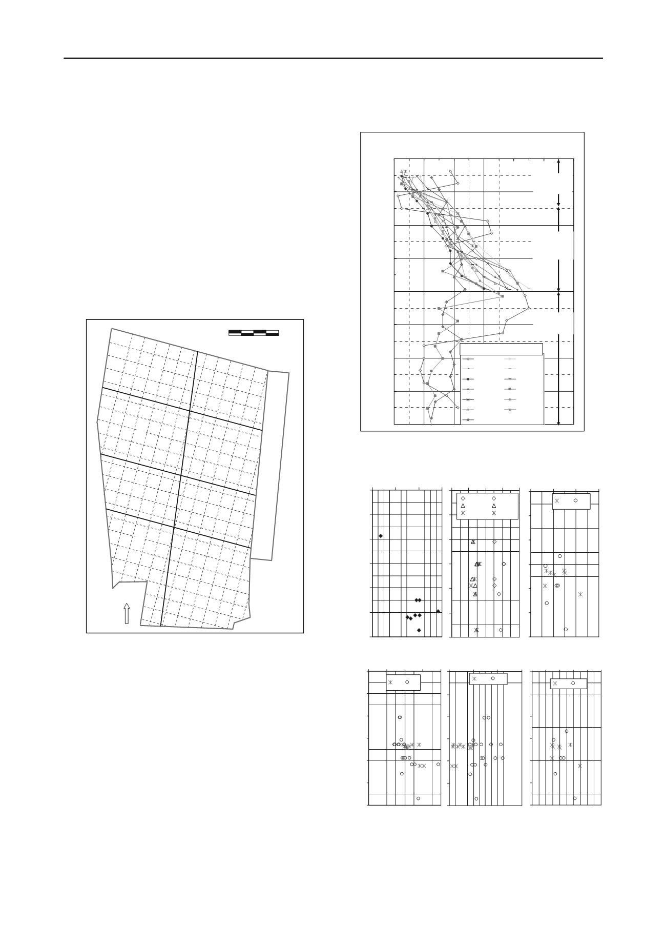
figure 2 presents the field spt-n values at different depths for
the explored borehole locations and the stratigraphy. in the top
silty clay layer, field spt-n values (not corrected for
overburden) ranged between 2 to 10. spt-n values greater than
10 in the top layer are for locations where pockets of sand/silt
exist. in the second layer (fine sand/silt), field spt-n values
ranged between 5 and 44. in the bottom layer, which is 'clayey
silt', the field spt-n values ranged between 5 and 27 except in
one borehole where a 'sandy silt' layer existed.
extensive laboratory tests have been conducted on samples
of top silty clay layer (Brtc, BUet report, 2009) and some of
the results are presented in figure 3. the layer may be
figure 2 General ground profile and variation of spt with depth.
-32
-28
-24
-20
-16
-12
-8
-4
0
0
8
16 24 32 40 48
SPT N-value (uncorrected)
Reduced Level, m
C-0 BL D-8 BL
D-6 BL E-4 BL
F-5 BL H-9 BL
H-7 BL I-5 BL
I-1 BL J-7 BL
L-8 BL L-6 BL
B-9 BL
Grid points
Silty clay
4~6 m
Fine
sand/silt
8~10 m
Claye silt
16m~
figure 1 site map showing grids and loading blocks.
0
2
3
4
1
5
6
7
8
9
10
11
12
13
14
15
16
17
18
19
C
D
E
F
G
H
I
J
K
L
M
N
1A
2A
1
2
3
4
3A
4A
N
KarnafUli riVer
Jetty deck
0 50 100
Distance in meter
figure 3 Variation of index, strength and deformation properties of the
upper clay deposit with rl (Bl=Before loading, al=after loading).
-6
-5
-4
-3
-2
-1
0
0 8 16 24
Fine content, %
Reduced Level, m
0 20 40 60 80
LL, PL, PI
LL/BL LL/AL
PL/BL PL/AL
PI/BL PI/AL
0
0.4 0.8 1.2 1.6
Void ratio, e
0
BL AL
-6
-5
-4
-3
-2
-1
0
10 20 30 40 50
MC, %
Reduced Level, m
BL AL
0 100 200 300
q
u
, kPa
BL AL
0
0 0.1 0.2 0.3 0.4 0.5
Comp. Index, C
c
BL AL


