1572
Proceedings of the 18
th
International Conference on Soil Mechanics and Geotechnical Engineering, Paris 2013
Proceedings of the 18
th
International Conference on Soil Mechanics and Geotechnical Engineering, Paris 2013
important archeological elements, but we are in conditions to
prevent these losses in the other areas.
In this work the results of the pioneering application of
geophysical and geotechnical techniques are presented, which
allowed constructing a preliminary vision of the plat
form’s
condition and origin and possible evolution of cracks.
2 GEOPHYSICAL-GEOTECHNICAL EXPLORATION
CAMPAIGN
To define the Gran Basamento
’s geotechnical model, a
geophysical-geotechnical non invasive campaign was carried
out, oriented to determine the thickness and quality of the
surface fills located at the zones where intense cracking is
present. It is important to comment that due to the project’s
characteristics, it is not possible to use the traditional
geophysical exploration equipment because it is necessary to
diminish as much as possible damage to the structure. To that
end, the penetration radar method (Barba 2006) was used, as
well as an ultra-light dynamic penetrometer, PANDA, and a
geo-boroscope, together with a geotechnical surveying of test
pits, exposed cuts inside the platform, as well as a survey of the
cracking observed on surface (inGeum 2005).
Through radar prospecting it is possible to obtain a general
idea, and on occasions a detailed one, of the location of the
various geological units. With the penetrometer, the thickness
and quality of the fills can be determined, and with the geo-
boroscope one can appreciate the granulometry of the materials
and their structure. Upon combining the information obtained
with the radar, the penetrometer and the geo-boroscope, the
geophysical exploration is calibrated and the geotechnical one is
extrapolated, to thus obtain a better image of the subsoil’s
conditions, with minimum damage to the archeological
structure.
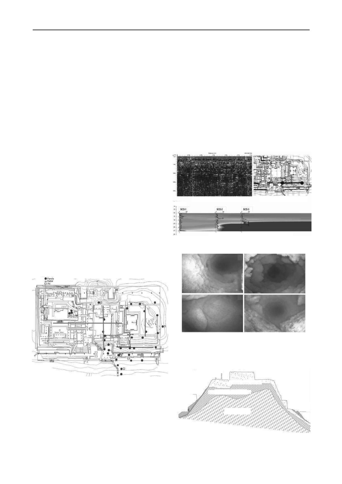
A total of 12 radar lines were carried out at the Gran
Basamento, 35 dynamic penetration soundings, 4 geo-
boroscopes in places where the dynamic penetration was carried
out, and 4 shallow test pits (Fig 2; inGeum 2005 and Barba
2006)).
Figure 2 Location of the dynamic penetrometer (PANDA), geo-radar
lines and shallow test pits.
3 STRATIGRAPHIC MODEL
Figure 3 shows the profiles obtained with the radar techniques
and the penetrometer along the slope located at the northeast
zone of the platform (Fig 3b), where the lateral variation of the
subsoil’s quality and hardness is seen (Fig
s 3a and 3c). Here the
surface fill’s thickness diminishes toward the north and
dynamic
resistance to penetration of cone q
d
increases also in this
direction (in Fig 3c the dark color indicates a high dynamic
resistance, and the light a low dynamic resistance). Also, Fig 3a
shows a comparison between the results of the georadar-
penetrometer techniques, where it is possible to observe a high
correlation between both techniques. This result is valuable
because the penetrometer is an additional tool that helps in the
georadar’s interpretation, and the latter can extrapolate the
results obtained with the penetrometer, which offers punctual
data, as mentioned previously. A detailed report on the use of
these techniques in archeological exploration is presented in
Barba (2006).
Additionally, a small geo-boroscope was used, which was
introduced in the perforation left by the penetrometer, in order
to observe the characteristics of the penetrated materials. With
this tool various types of fill were observed, related to different
construction stages of the pyramid. Fig 4 shows some photos
taken with the boroscope, which show the various fills that were
penetrated: a) sandy silt, b) silty sand, c) sandy silt with gravel
and d) fill with archeological remains.
Figure 3 Typical results of the exploration with Georadar and Dynamic
Penetrometer.
Figure 4. Photos taken with the geo-boroscope
inside the penetrometer’s
perforation.
Derived from the geophysical-geotechnical exploration and
preliminary information, a surface stratigraphic model was
determined for the Gran Basamento. In synthesis, there are three
surface geotechnical units (Fig 5):
Figure 5 General stratigraphic model
a
c d
b
Organic soil
Volcanic tuff
Prehispanic structured fill
Non structured fill
Organic
soil
Recent
fill
Level
a) Georadar and penetrometer data
b) Location of the section
c) Isoresistence curves from dynamic penetrometer


