2751
Slope stability structures for road landslide
Structures de stabilité de pentes pour glissement de terrain
Hamova M., Frangov G., Zayakova Hr.
Higher School of Civil Engineering “L. Karavelov” – Sofia, Bulgaria
ABSTRACT: Landslide had appeared on main road affecting more than half of the roadway and caused traffic difficulties. The
landslide had a width in the top 55 m, length - 38 m and maximum depth of 8-9 m. Groundwater table rising, river erosion
undermining the slope and the dynamic effects of transport were defined as key factors for slope instability. Cantilever retaining wall
on driven pile’s foundation, in addition with trailing plate and drainage facilities for landslide stabilization were designed and
constructed. The monitoring of strengthened road section during the period 2006 - 2012, shows that the landslide was successfully
stabilized and new landslide deformations have not been established.
RÉSUMÉ : Un glissement de terrain est apparu sur une route principale affectant plus de la moitié de la chaussée et perturbant
terriblement le trafic. La surface de glissement avait les dimensions suivantes: largeur dans la partie supérieure - 55 m, longueur - 38
m sur une profondeur maximale de 8 à 9 m. On a considéré que l’instabilité de la pente était le résultat des facteurs suivants : nappe
phréatique, érosion croissante provoquée par la rivière, effets dynamiques du trafic. Un mur de soutènement fondé sur des pieux, un
sol renforcé par inclusion et des drainages ont été conçus et construits pour stabiliser l’ensemble. L’analyse du profil en travers de la
route entre 2006 et 2012 montre que le glissement a été stabilisé et qu’aucun nouveau déplacement n’a été observé.
KEYWORDS: Landslide, slope instability, stabilization, cantilever retaining wall, driven piles, drainage facilities.
1 INTRODUCTION
Many landslides have appeared every year on the roads of
Bulgaria triggering by various factors and causing serious traffic
problems (Ivanov & Dobrev, 2006). Such landslide had
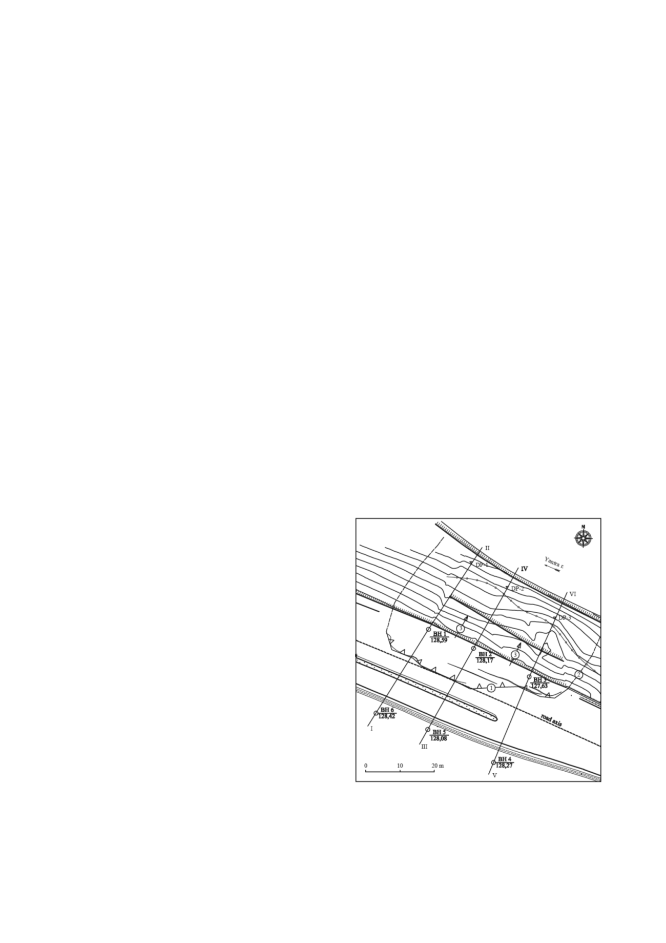
occurred on the main road Ruse - Veliko Tarnovo in October,
2005. The landslide had affected more than half of the roadway
and it had a width at the top 55 m. This part of the road for a
few days had slide up to 70 cm. Wide open cracks had been
clear observed on the roadway (fig. 1).
Tension cracks were hardly noticed without vertical escarp at
the beginning of sliding. The impression was that only
horizontal movement of the landslide had occurred toward the
rest of the terrain. The appearance of the landslide was preceded
by anomalously high precipitation. Overall it was a wet year,
and the annual rainfall amounted to 163% compared to the
norm. Rainfalls had formed significant surface runoff,
increasing water levels in the river Yantra and the related
increase in the levels of groundwater. The subsequent rapid
drop in the river water levels had caused reverse filtration and
occurrence of high groundwater gradient toward the river.
2 GEOLOGY AND CLIMATE
2.1. Geomorphology
The studied area represents a system of low hills with well-
defined crests with west-east direction. More expressive heights
are Tarnovo Hils with oversea levels - 300 to 400 m. Main
artery Yantra River cuts through the Turnovo mountain forming
pictorial Dervish Gorge. Belyakovo and Arbanasi Plateaus are
located to the west and the east of the gorge. The northern
slopes of Turnovo Hills are steep and there the Danube plain
border is marked. The survey landslide is on the highway Ruse -
Veliko Tarnovo on the left slope of the Yantra River. The slope
is too steep to vertical at the top and low-grade - at the bottom.
Figure 1. Location map of landslide: 1 - main scarp; 2 - lateral
boundary; 3 - movement direction; BH 2 - borehole No 2; DP 1 -
dynamic probing No 1; I - II - engineering geological cross-section


